University of Tulsa
Mountain Cedar Pollen Forecast
Date Issued: 26 December 2000
Mountain Cedar location(s): Ozark Mountains, AR/MO
Regional weather: Tuesday, December 26 - TX/OK/AR: Major winter storm in progress: The weather situation has evolved as expected in the south-central U.S. over the past several days. Precipitation in all forms, much of it heavy, fell yesterday in the region and continues unabated today. Snow, sleet, freezing rain, showers, and thunderstorms can be found. The system will affect the region again on Wednesday, then slowly move to the east as the day progresses. Highs from the 20's and 30's north to 50's and 60's south. Lows ranging from the 10's and 20's north to 40's south and east.
Trajectory weather: Freezing rain, possibly mixed with sleet today, high near 30. Freezing rain and sleet tonight, low in the mid-20's. Freezing rain and sleet on Wednesday, changing to rain late in the day. High in the 30's.
Trajectory confidence: High
OUTLOOK: *** Low Threat *** Conditions are highly unfavorable for release today. Winter storm warning in effect around the source region. Temperatures are far too cold and precipitation is ongoing. No pollen release is expected. TK
Trajectory Start(s) (shown by black star on map): Oak Grove, AR
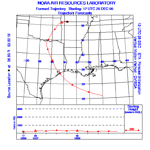
Prepared by: Thomas Keever (Department of Marine, Earth and Atmospheric Sciences, NCSU), Estelle Levetin (Faculty of Biological Science, The University of Tulsa, 600 S. College, Tulsa, OK 74104), and C.E. Main (Department of Plant Pathology, North Carolina State University, Raleigh, NC 27695-7618). This forecast gives the anticipated future track of released Mountain Cedar pollen, weather conditions over the region and along the forecast pathway, and an estimated time of arrival for various metropolitan areas.
Questions: Aerobiology Lab e-mail: pollen@utulsa.edu
Return to Forecasting Home Page