University of Tulsa
Mountain Cedar Pollen Forecast
|
Metropolitan Area |
Exposure Risk |
|
Dallas / Ft. Worth |
Low |
|
Austin |
Low/Moderate |
|
San Antonio |
Moderate |
Date Issued: 30 December 2000
Mountain Cedar location(s): Edwards Plateau, Texas
Regional weather: Friday - Sunday, December 29-31 - TX/OK/AR: High pressure in control of the weather today and Saturday. By Sunday, a disturbance will move into the region from the west. Winds, moderate on Friday and mostly light on Saturday, will be turning to the south and southeast, increasing the moisture inflow into the region. Chance of snow or rain for many areas. Highs mostly in the 30's to 50's each day with some 20's and 60's at the northern and southern edges. Lows mostly in the 10's to the 30's.
Trajectory weather: Mostly sunny today, high in the upper 40's to low 50's. Increasing clouds tonight with a slight chance of snow or sleet late, low in the 20's. Cloudy with a chance of snow on Sunday, high in the 30's.
Trajectory confidence: High.
OUTLOOK: *** Low/Moderate Threat *** Mixed conditions for pollen release today. Forecast highs range from the upper 40's northern Plateau to mid-50's southern fringes, a little warmer than Friday. Humidities are on the unfavorable side in much of the north and east but should become at least slightly favorable during the afternoon in the south and west. Winds are light, but will be picking up during the afternoon.... moreso in the western Plateau. In general, conditions support some pollen release during the afternoon hours in the southern and western sections of the Plateau. Little release is expected from the northern and eastern sections. Moderate Risk of exposure for parts of south-central and west-central TX by Saturday evening, and western sections of north TX (east of Highway 70 and west of US 281) during the night. This includes the metropolitan area of San Antonio... and perhaps Austin. Low Risk of exposure otherwise on Saturday. Precipitation is expected on Sunday in Oklahoma, and given the amount of release expected, residents there should be at Low Risk of exposure. On Sunday.... little release is expected. Temperatures will be much like Friday's. However, humidity levels are expected to increase with the moist southerly/southeasterly flow, and will likely remain well above the favorable range without dropping. Precipitation is in the forecast for the southeast sections of the Plateau. Winds will be moderate from the south, then turning to the north by mid-evening. Any release that occurs will be from the western end of the Plateau, but amounts should be light. Overall ... Low Risk of exposure on Sunday. TK
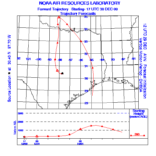
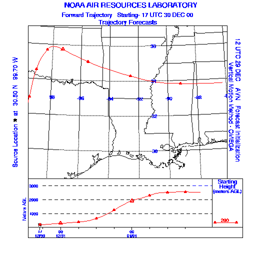
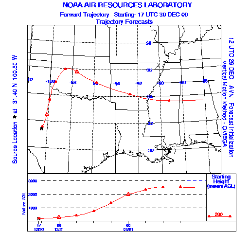
Trajectory Start(s) (shown by * on map): Austin, TX; Junction, TX; San Angelo, TX
Austin, TX
Junction, TX
San Angelo, TX
Prepared by: Thomas Keever (Department of Marine, Earth and Atmospheric Sciences, NCSU), Estelle Levetin (Faculty of Biological Science, The University of Tulsa, 600 S. College, Tulsa, OK 74104), and C.E. Main (Department of Plant Pathology, North Carolina State University, Raleigh, NC 27695-7618). This forecast gives the anticipated future track of released Mountain Cedar pollen, weather conditions over the region and along the forecast pathway, and an estimated time of arrival for various metropolitan areas.
Questions: Aerobiology Lab e-mail: pollen@utulsa.edu
Return to Forecasting Home Page