University of Tulsa
Mountain Cedar Pollen Forecast
|
Metropolitan Area |
Exposure Risk |
|
Dallas / Ft. Worth |
High |
|
Austin |
Mod |
|
San Antonio |
Low |
Date Issued: 20 December 2001
Mountain Cedar location(s): Edwards Plateau, Texas
Regional weather: Thursday, December 20 TX/OK/AR: High pressure will remain over the southern plains today but will begin to move to the east tomorrow with an increasing chance of showers to the north and along the eastern edge of the Edwards Plateau tomorrow night. Regional winds will be light, from southerly directions today then increase to moderately strong tomorrow. Temperatures remain in the mid 60 s throughout the Texas hill country and Edwards Plateau region, with a 5 degree cooling in Oklahoma and the Ozark Mountain region. Low temperatures are in the low 40 s south and north with near freezing conditions in the Ozark Mountains. Tomorrow, high temperatures remain relatively constant but low temperatures will only reach the lower 50 s to upper 40 s throughout the region as warmer tropical air is drawn into the southern plains. Winds will be increasingly strong from the south with an increased chance of precipitation along the eastern edge of the Edwards Plateau and to the northeast near the Ozark Mountains.
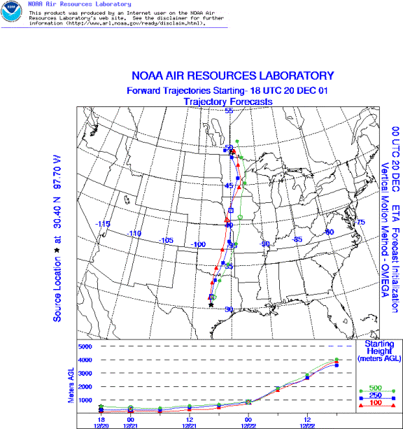
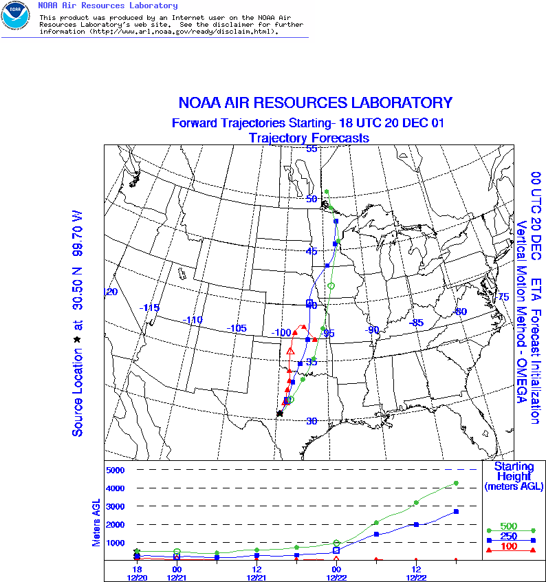
Trajectory weather: The trajectories from the southern plains all move rapidly to the north, especially at the upper elevations. An upper level low pressure to the north dominates the movement of the upper elevation air masses. Along the western edge of the Edward s Plateau the surface winds continue to move along the ground and little elevation is gained, whereas the trajectory from the Austin area indicates that the surface winds initially move along the ground but are then swept up in elevation to the north. Throughout the region strong sun conditions, increasing wind speeds, and low relative humidity will favor pollen release, entrainment and travel. This is especially true on the eastern edge of the Plateau compared to the west.
Trajectory confidence: High.
OUTLOOK: *** Serious Threat *** very favorable conditions for pollen release today. Over the Plateau temperatures, humidity, strong winds and good sun conditions will favor pollen release. Indications from the Edwards Plateau suggest that the pollination season has begun recently; therefore a majority of the cones will remain closed. Pollen that is entrained within the region should be transported north. This is especially true on the eastern Edwards Plateau where the trajectories suggest conditions that will sweep pollinating trees and then gain elevation as they travel to the north. These conditions are characteristic of past influx events. Therefore, Waco, Dallas/Fort Worth, Oklahoma City and Tulsa are all at risk for the influx of Juniperus ashei pollen. The areas surrounding the Edwards Plateau, Waco and Austin will see a moderate risk of pollen influx from the surrounding areas, especially where populations occur to the south of these locations.
Trajectory Start(s) (shown by *on map): Austin, TX; Junction, TX; San Angelo, TX
Austin, TX
Junction, TX
San Angelo, TX
Prepared by: Peter K. Van de Water (Department of Geosciences, Oregon State University), and Estelle Levetin (Faculty of Biological Science, The University of Tulsa, 600 S. College, Tulsa, OK 74104) This forecast gives the anticipated future track of released Mountain Cedar pollen, weather conditions over the region and along the forecast pathway, and an estimated time of arrival for various metropolitan areas.
Questions: Aerobiology Lab e-mail: pollen@utulsa.edu
Return to ForecastingHome Page