University of Tulsa
Mountain Cedar Pollen Forecast
|
Metropolitan Area |
Exposure Risk |
|
Dallas / Ft. Worth |
Low |
|
Austin |
Low |
|
San Antonio |
Mod |
Date Issued: 22 December 2001
Mountain Cedar location(s): Edwards Plateau, Texas
Regional weather: Saturday, December 22 TX/OK/AR: Today a cold front swings through the region with the low centered over central Nebraska, dropping nighttime temperatures into the mid to lower 30 s in central Texas and the upper 30 s along the eastern edge of the Edwards Plateau. To the north, temperatures will reside in the 50 s throughout Oklahoma and the Ozark Mountain region. Low temperatures will be in the upper 20 s to just below freezing. Partly cloudy skies will dominate throughout the region with precipitation, in the form of showers, building along a north to south line in eastern Texas and Oklahoma. Chances of precipitation range from 60% in the Ozark Mountains to 40% in Tulsa, Waco, Dallas and Austin. Winds will be moderate and from the west to southwest throughout the region. On Sunday skies will clear but cold arctic air will begin to flow south dropping high temperatures by 7 to 10 degrees. The central Texas area will barely reach 60 degrees. Low temperatures will be in the 20 s throughout the region. In Oklahoma a similar scenario leaves the high temperatures in the low 40 s and lows in the low 20 s. The Ozark Mountains will see highs in the 30 s and lows in the teens. Winds will remain moderate out of the north to northeast in Texas and west to northwest in Oklahoma and the Ozark Mountain region.
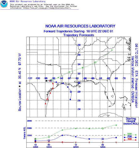
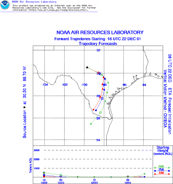
Trajectory weather: The trajectories from the western Edwards Plateau move rapidly to the southeast then shift towards the south. The wind elevations show sinking air that forces the air masses to move at ground level. Throughout the eastern portions of the region partly cloudy conditions, moderate wind speeds and high relative humidity will not favor pollen release, entrainment or travel. However, sunny warm conditions will continue on the western side of the Plateau.
Trajectory confidence: High.
OUTLOOK: *** Mod Threat to the west, Low Threat to the east *** favorable conditions for pollen release to the west, unfavorable conditions for pollen release to the east. Over the Plateau temperatures, humidity, moderate winds and sunny conditions will favor pollen release on the western edge of the Edwards Plateau. However, partly cloudy conditions and a chance of precipitation to the east should decrease the chance of release. If pollination occurs, the wind trajectories indicate that the winds will result in movement at ground level towards San Antonio and the southern edge of the Edwards Plateau. The air characteristics are unsuitable for large amounts of pollen to be entrained and moved along these trajectories. Therefore only a moderate chance of influx is expected, if any, into the San Antonio region. Low temperatures and high humidity levels should result in unfavorable pollination conditions on Sunday for the entire region. Winds will be predominantly out of the north to northeast so the air masses should move towards the southern edge of the Edwards Plateau.
Trajectory Start(s) (shown by *on map): Austin, TX; Junction, TX; San Angelo, TX
Austin, TX
Junction, TX
San Angelo, TX
Prepared by: Peter K. Van de Water (Department of Geosciences, Oregon State University), and Estelle Levetin (Faculty of Biological Science, The University of Tulsa, 600 S. College, Tulsa, OK 74104) This forecast gives the anticipated future track of released Mountain Cedar pollen, weather conditions over the region and along the forecast pathway, and an estimated time of arrival for various metropolitan areas.
Questions: Aerobiology Lab e-mail: pollen@utulsa.edu
Return to ForecastingHome Page