University of Tulsa
Mountain Cedar Pollen Forecast
|
Metropolitan Area |
Exposure Risk |
|
Dallas / Ft. Worth |
High |
|
Austin |
High |
|
San Antonio |
Low |
Date Issued: 27 December 2001
Mountain Cedar location(s): Edwards Plateau, Texas
Regional weather: Thursday, December 27, TX/OK/AR: The strong upper level low pressure in the Great Lakes region continues to influence the weather of the southern plains. A weak low pressure has developed over eastern New Mexico and will move to the east through west Texas, across northern Texas and then to the southeast over the next 24 to 48 hours. Sunny skies will occur in west Texas but the influx of moister gulf air to the east along the edge of the Edwards Plateau will result in mixed clouds and sunshine today. Temperatures throughout the Texas region will be in the mid 60 s with lows below freezing to the west and in the upper 30 s to low 40 s to the east. To the north in Oklahoma high temperatures will be 10 to 15 degrees colder with low temperatures near freezing. Skies will be cloudier with winds circulating around the low pressure centered over the Great Lakes creating moderate northerly winds that will diminish tonight. As the trough associated with the low pressure to the south moves through the area wind direction will shift to west to southwest. On Friday, conditions will improve dramatically to the south as High pressure reestablishes over the Edwards Plateau. Temperatures will be in the high 60 s throughout the region and lows in the lower 40 s. To the north temperatures will rise to the mid 50 s but lows will remain below freezing as another weather system begins to move across the area. Cloudy conditions will remain. Watch for tomorrow s forecast as conditions for pollen release and entrainment look good for Friday.
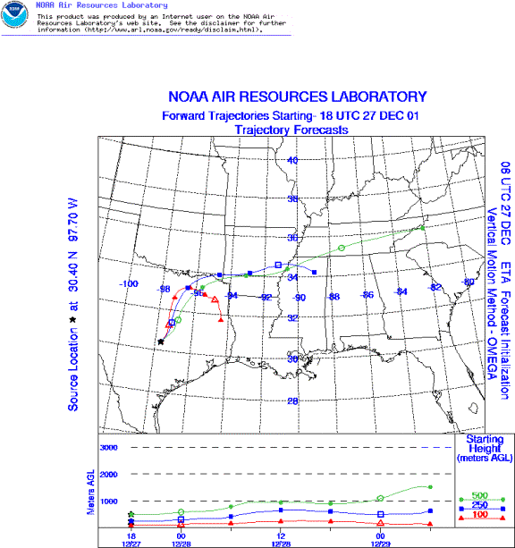
Trajectory weather: The trajectories from the western Edwards Plateau move to the northeast then turn towards the southeast. The air masses do rise off of the Edwards Plateau then travel primarily over eastern Texas on light winds. The warm temperatures, and current dry conditions as well as moderate wind speeds favor pollen release. However changes in humidity and wind direction will occur as the low pressure and associated trough moves through northern Texas
Trajectory confidence: High.
OUTLOOK: *** Serious threat to the east *** very favorable conditions for pollen release. Over the Plateau warm temperatures, moderate winds and low relative humidity are right for pollen release. Characteristics of the air masses, showing rising air off of the Edwards Plateau, are right for entrainment and deposition downwind of the source areas. However, the trajectories show movement primarily restricted to those areas to the east of the Edwards Plateau region as well as changing conditions throughout the day and into the evening. Areas to the north will be more influenced by cloudy conditions and increased humidity. Therefore the sever threat exists for Waco, Austin and potentially Dallas.
Trajectory Start(s) (shown by *on map): Austin, TX; Junction, TX; San Angelo, TX
Austin, TX
Junction, TX
San Angelo, TX
Prepared by: Peter K. Van de Water (Department of Geosciences, Oregon State University), and EstelleLevetin (Faculty of Biological Science, The University of Tulsa, 600 S. College, Tulsa, OK 74104) This forecast gives the anticipated future track of released Mountain Cedar pollen, weather conditions over the region and along the forecast pathway, and an estimated time of arrival for various metropolitan areas.
Questions: Aerobiology Lab e-mail: pollen@utulsa.edu
Return to ForecastingHome Page