The
Mountain
Cedar Pollen Forecast
Metropolitan Area |
Exposure Risk |
|
|
Low |
|
|
Moderate |
|
|
Moderate |
Date Issued:
Mountain Cedar Location(s):
Regional Weather: Wednesday, December 18 TX/OK/AR: Conditions across the region will continue to be warm today with a trough of low pressure moving through the area. Clouds with showers will occur to the north in northeastern Oklahoma and northwestern Arkansas today with thunderstorm building over south Texas this afternoon along the southeastern edge of the Edwards Plateau. These conditions will dissipate overnight and sunny conditions will prevail across Texas tomorrow. To the north partly cloudy to mostly cloudy conditions will continue with a chance of rain from 10 to 20 percent. In Texas, temperatures will remain warm, in the upper 60s to low 70s today and 5 degrees cooler tomorrow. There is a strong west to southwesterly flow across the area with moderate winds today, becoming strong this afternoon in some places. Moderate winds will be sustained overnight but switching to a west to northwest direction tonight and into tomorrow. Overnight temperatures will be cool ranging from the 30s and 40s in the west to the low 50s along the southeastern edge of the Edwards Plateau. To the north cloudy conditions will prevail today and tomorrow with a chance of precipitation both days. Temperatures will be in the low 60s today cooling by 10 degrees tomorrow. Winds throughout the region will remain moderate from the southwest today switching to a north to northwest flow overnight.
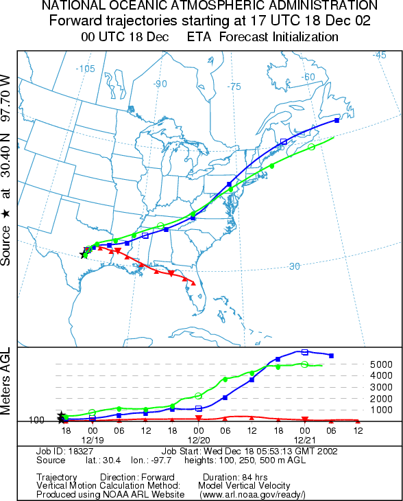
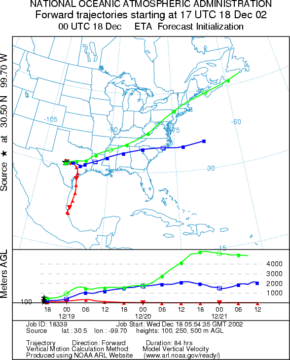
Trajectory weather: The lower air mass trajectories from Texas move to the west passing over eastern Texas and into Louisiana towards the southeast. The upper elevation winds from all three sites are caught in the jet stream and move rapidly towards the northern east coast. The upper winds show good buoyant air whereas the lower winds show the effects of colder air entering the region that keeps the air movement near ground level. Cloudy conditions and higher humidity along the eastern edge of the Edwards Plateau may restrain some of the trees from fully releasing. In addition thunder storms development is expected along the southeastern edge of the Edwards Plateau however there will dryer conditions to the west and strong winds this afternoon. Conditions will settle tomorrow as sunny but cool conditions will prevail across the region. Today, the conditions are mixed for release, entrainment and travel.
OUTLOOK: ***Moderate Threat today***mixed conditions for pollen release today. Cloudy skies with the threat of thunder storms this afternoon will occur over the Plateau today but with dryer conditions towards the west combine for mixed release conditions for the trees. Atmospheric concentrations of pollen are reported indicating that the trees have begun to ripen and release to the atmosphere. Moderate to strong winds and warm temperatures are in favor of pollen release, but the trajectory characteristics are not good for significant long-distance travel. Therefore there is a moderate threat to communities close to the source, Austin and San Antonio, but that threat rapidly declines downwind and in region to the north. Sunny skies, but cooler conditions will return to the region tomorrow
Trajectory Start (s)
(shown by *
on map):
Junction, TX
Prepared by: Peter
K. Van de Water (Department of Geoscience,
Questions: Aerobiology Lab e-mail: pollen@utulsa.edu
Return to Forecasting Home Page