The
Mountain
Cedar Pollen Forecast
Metropolitan Area |
Exposure Risk |
|
|
Low |
|
|
Low |
|
|
Low |
Date Issued:
Mountain Cedar Location(s):
Regional Weather: Monday, December 23 TX/OK/AR: Conditions across the southern regions will be wet today and tomorrow with winter weather across the Texas and Oklahoma panhandle, extending to the east overnight and into Tuesday. Conditions will include rain and thunderstorms to the south, snow and freezing rain across the Texas panhandle and a wintery mix of rain and freezing rain to the north. Temperatures will be much cooler with the highs in Oklahoma in the low 40s today and in Texas dropping into the 40s as the cold air behind the front moves into the area. Overnight the northern areas will see temperatures at or near freezing with snow showers from the Oklahoma City region north. Areas around the southern edge of the Edwards Plateau will be in the upper 50s to mid 60s today but cooling by at least 10 degrees tomorrow. Ahead of the cold front turbulent atmospheric conditions will result in rain and thunderstorms across the southern Edwards Plateau region. Cloudy conditions, high humidity and moderate winds will prevail across the region today and tomorrow.
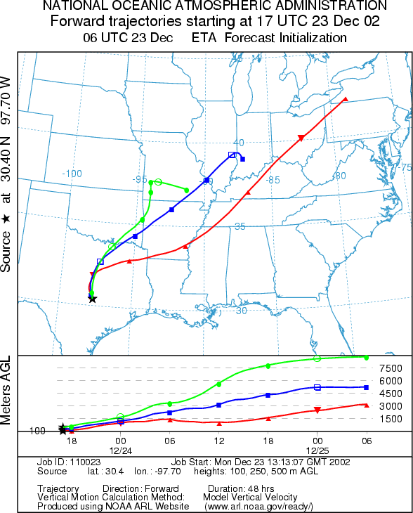
Trajectory weather: The air mass trajectories from Texas move to the north-northeast ahead of the cold front moving into the area. The mix of warm and cold air results in turbulence that results in atmospheric conditions conducive to entrainment and long-distance travel of particles. However conditions are not good for pollen release today or tomorrow as a significant weather event moves through the region. As the cold front passes today winds will switch from the southwest to the north bringing the trajectory winds almost 180 degrees in the opposite direction. This can be seen comparing the Austin and Junction trajectories to those from San Angelo. The western Plateau winds move towards the northeast at a fast rate heading towards the northeastern United States whereas those from the western side of the Plateau move towards the south
OUTLOOK: *** Low Threat today ***Unfavorable conditions for pollen release today. Cloudy skies, with cooling temperatures, moderate winds and high humidity with a significant chance of precipitation across the region will prevail across the region today making for unfavorable conditions for pollen release within the trees. Even with good trajectory characteristics for significant long-distance travel rain throughout the region should dampen the chances of any pollen getting into the atmosphere. Conditions will begin to improve tomorrow afternoon, but moist cloudy conditions should extend overnight into tomorrow morning.
Trajectory Start (s)
(shown by *
on map):
Junction, TX
Prepared by: Peter
K. Van de Water (Department of Geoscience,
Questions: Aerobiology Lab e-mail: pollen@utulsa.edu
Return to Forecasting Home Page