The
Mountain
Cedar Pollen Forecast
Metropolitan Area |
Exposure Risk |
|
|
Low/ Low |
|
|
Low/ Low |
|
|
Low/ Low |
Date Issued:
Mountain Cedar Location(s):
Regional Weather: Tuesday, December 24 and Wednesday December 25 TX/OK/AR: Conditions across the southern regions will be cold today and tomorrow with winter weather moving east out of the region. To the north snow showers and flurrys should end this morning to early afternoon. To the south cloudy and mostly cloudy conditions will prevail across the region. High temperatures will be in the low to mid 30s to the north and only the upper 40s across the Edwards Plateau. Winds will continue to be from the north funneling more cold air southward throughout the day and humidity will remain high. Overnight temperatures will be very cold with lows in the lower 20s north to upper 20s in the south region. Wednesday: Christmas will bring similar conditions but with increasing sun breaks in the southern regions. Temperatures will remain cold with high temperatures along the southern edge of the Edwards Plateau just getting into the 50s. In Oklahoma, the high temperatures will struggle to get out of the 30s. Winds will remain moderate to light predominantly from the northwest but shifting out of the south to southwest as high pressure begins to build over the region. Conditions will continue to dry, but humidity will remain close to or above 50%.
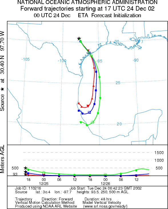
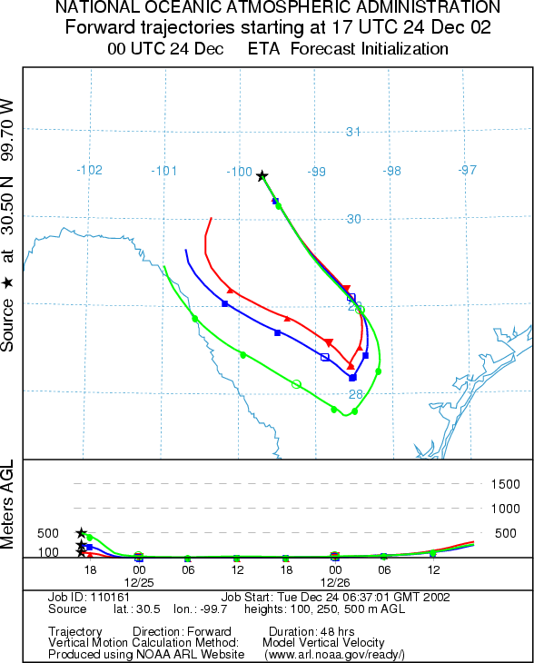
Trajectory weather: The air mass trajectories from Texas move to the south on cold air flowing into the region behind the cold front that came through yesterday. The trajectory characteristics show the influence of this northern incursion with the heavier cooler air remaining near the ground surface throughout the region. Cold temperatures and high humidity will be the rule across the Edwards Plateau today with a slight chance of precipitation reforming regionally. Wednesday: Cold conditions will be maintained as low temperatures tonight dip into the upper to mid 20s across the region. High temperatures tomorrow will once again struggle to get into the 50s along the southern edge of the Edwards Plateau. Sunny skies will prevail to the south with partly to mostly cloudy conditions in northern Texas. Conditions will continue to dry and winds will remain light. However, the wind direction will begin to shift to the south to southwest resulting in the trajectories traveling northward from the source areas.
OUTLOOK: *** Low Threat today, Tuesday and Low to moderate threat tomorrow, Christmas Day ***Unfavorable conditions for pollen release today with mixed conditions tomorrow. Cloudy skies, with cold temperatures, moderate winds and high humidity will prevail across the region today making for unfavorable conditions for pollen release within the trees. Tomorrow clearing skies will bring sun to the region but continued cold temperatures and an overall drying of the region will result in mixed conditions for release. Poor characteristics of pollen entrainment and travel exist from the trajectories thus a low threat exists today. Conditions do improve tomorrow with southerly winds beginning and a bit more buoyancy in the atmosphere tomorrow.
Trajectory Start (s)
(shown by *
on map):
Junction, TX
Prepared by: Peter
K. Van de Water (Department of Geoscience,
Questions: Aerobiology Lab e-mail: pollen@utulsa.edu
Return to Forecasting Home Page