The
Mountain
Cedar Pollen Forecast
Metropolitan Area |
Exposure Risk |
|
Dallas/Fort Worth |
Moderate to High |
|
|
Moderate to High |
|
|
Low to Moderate |
Date Issued:
Mountain Cedar Location(s): Edwards Plateau, Texas
Regional Weather: Friday, Saturday and Sunday, Dec 26 to 28. TX/OK: Mild weather continues but clouds move into the region bringing moist air and strong southerly winds ahead of a cold front that will move through the region this weekend. Friday will be partly to mostly cloudy throughout the region with strong southerly winds. Temperatures will be in the 60s to low 70s in Texas and 50s to 60 in Oklahoma. Nighttime temperatures will be mild, dropping only about 10 degrees. Saturday will be cloudy with rain chances increasing throughout the day. Thunderstorms are likely to occur. Southerly winds will continue with temperatures in the 60s in the north and 70s in the south. The cold front will push through the area late Saturday night into Sunday morning shifting winds to the northwest and bringing temperatures down about 10 degrees. Clearing skies will begin on Sunday decreasing the chance of precipitation during the day. Temperatures will range from mid 50s to mid 60s through the region..
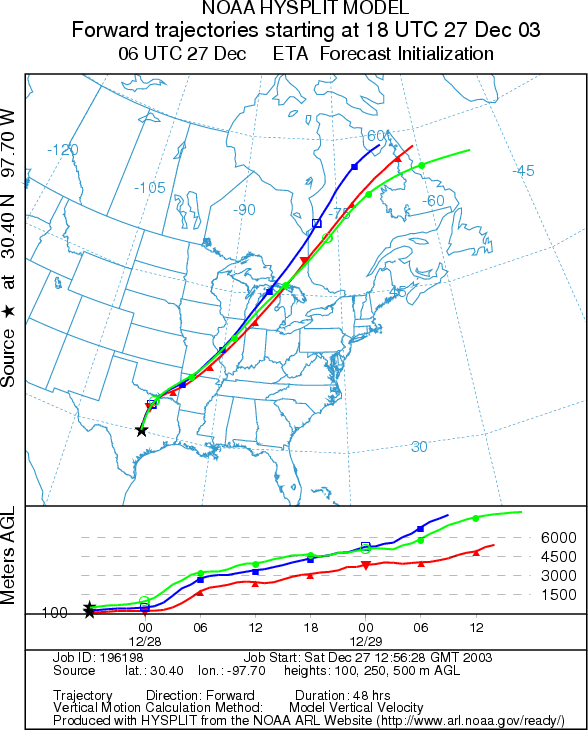
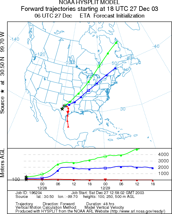
Trajectory weather: Trajectories from eastern side of the Plateau move rapidly north, northeast ahead of the cold front. Low level trajectories from the western edge of the front start out in the northeast direction but get caught up in the front Saturday night and turn east then south. Upper level trajectories continue north, northeast. Weather at the source will continue to be humid with chance of rain and thunderstorms during the day. After the frontal system passes through the area, temperatures will be 10 degrees cooler than Saturday and humidity will be low. Trajectories on Sunday will move south but show poor characteristics for entrainment and travel of pollen downwind as cold air drains into the area. Cold sinking atmospheric conditions results in the air-masses moving along the ground where any entrained particles are quickly filtered.
OUTLOOK: *** Moderate to High Exposure Risk *** Mixed conditions for pollen release. High humidity today and chance of rain may slow or inhibit pollen release; however, winds are strong and any pollen that may be shed will be transported. Conditions on Sunday are favorable for release but trajectories show poor characteristics for entrainment and travel of pollen. Any released pollen will likely remain close to the sources.
Trajectory Start (s) (shown by *
on map): Austin, TX; Junction, TX; San Angelo, TX.
AUSTIN
JUNCTION
SAN ANGELO
Prepared by: Estelle
Levetin (Faculty of Biological
Science, The University of Tulsa, 600 S. College, Tulsa, OK 74104). This forecast gives
the anticipated future track of released Mountain Cedar pollen, weather conditions over the region and along the
forecast pathway, and an estimated time of arrival for various metropolitan areas.
Questions: Aerobiology Lab e-mail: pollen@utulsa.edu
Return to Forecasting Home Page