The University of Tulsa
Mountain Cedar Pollen Forecast
Metropolitan Area |
Exposure Risk |
|
Oklahoma City |
Low |
|
Tulsa |
Low |
|
St. Louis MO |
Low |
Date Issued: 21 Dec 2004
Mountain Cedar Location(s): Arbuckle Mountains, OK
Regional Weather: Wednesday and Thursday, Dec 22 and
23. TX/OK: A strong arctic front will move across the southern plains on Wednesday dropping temperatures
20 to 30 degrees from Tuesdays readings. Temperatures in Oklahoma and north Texas will be in the upper 20s to upper
30s. Highs in south Texas will be in the 50s. Strong northerly winds throughout the area with a chance of precipitation
on Wednesday. Some areas in Oklahoma will receive snow and there is a chance of rain in parts of Texas. Frigid
temperatures will continue on Thursday and Friday as the cold air covers the region. Daytime highs will be in the
20s and 30s throughout the region. Night time lows in the single digits to teens in the north and low 20s in the
south.
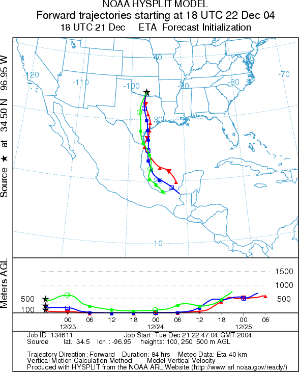
Trajectory weather: The air mass trajectories move from the Arbuckle Mountains to the south over central Texas on strong northerly winds. The trajectories show poor characteristics for entrainment and travel of pollen downwind as cold air drains into the area. Cold sinking atmospheric conditions results in the air-masses moving along the ground where any entrained particles are quickly filtered. In addition low temperature at the source will inhibit pollen release in the Arbuckles.
OUTLOOK: *** Low Threat today
*** unfavorable conditions for pollen release. Frigid temperatures over the next
few days will inhibit pollen release
Trajectory Start (s) (shown by black
star on map): Sulfur, OK.
Prepared by: Estelle
Levetin (Faculty of Biological
Science, The University
of Tulsa, 600 S. College, Tulsa, OK 74104). This forecast gives the anticipated future track of released
Mountain Cedar pollen, weather conditions over the region and along the forecast pathway, and an estimated time
of arrival for various metropolitan areas.
Questions: Aerobiology Lab e-mail: pollen@utulsa.edu
Return to Forecasting Home Page