The University of Tulsa
Mountain Cedar Pollen Forecast
Metropolitan Area |
Exposure Risk |
|
Dallas/Fort Worth |
Moderate |
|
Austin |
Moderate |
|
San Antonio |
Low |
Date Issued: 29 December 2005
Mountain Cedar Location(s): Edwards Plateau, Texas
Regional Weather: Thursday
and Friday, Dec 29 and 30. TX/OK:
High pressure continues to shift across the region toward the southeast with low pressure moving across the northern
plains, shifting the winds towards a northerly direction today. A weak low pressure will begin to drop towards
the southeast from the northern Rockies bringing cooler but dry conditions Friday. Today the region will be relatively
clear with temperatures in the upper 60s and relatively dry conditions as humidity will be around 40% during the
day. Nighttime temperatures will be in the low 40s with clear skies. Tomorrow, temperatures will be 5 to 10 degrees
cooler, but will continue to be relatively dry. In Texas, skies will continue to be clear with daytime highs in
the low to mid 70s across the region. Nighttime temperatures will remain above the freezing mark, in the low
to mid 40s region wide. Relative humidity will continue to be low during the day with little chance of precipitation
throughout the region. Temperatures across Texas will increase on Friday by about 5 degrees with the southern
areas approaching 80F. Daytime winds will increase tomorrow with speeds between 10 and 20 miles/hour, decreasing
overnight, then switching from a southerly direction to northerly on Friday.
Trajectory weather: The air mass trajectories from the Edwards
Plateau Texas move to the north today, then as the low pressure moves southeastward across the region the trajectories
move to a more southerly direction as winds come about from the north. The trajectories on the eastern edge of
the Plateau follow the movement of the upper mid-west low pressure northeast whereas those to the west show turn
towards the southeast at the lowest elevations. Sinking atmospheric conditions characteristic of the western Plateau
sites are poor characteristics for entrainment and travel therefore any pollen released should remain relatively
close to the source. To the east, atmospheric conditions are rising as they travel northeast passing over the
Dallas/Fort Worth Area Weather conditions will be good for pollen release (see outlook) with temperatures in the
upper 60s to low 70s today and mid to upper 70s tomorrow, clear skies and low relative humidity. Nighttime temperatures
will remain above freezing in the low to mid 40s to the east and low 40s in the west.
OUTLOOK: *** Low-Moderate threat *** Although temperatures are optimal for pollen release, the severe drought
throughout the region has delayed the pollen season. At this time we do not have confirmation that the trees have
started to pollinate significantly. However, atmospheric pollen counts from the Austin area are small but show
increasing amounts of cedar pollen. These conditions may affect those with extreme sensitivities. Therefore,
if pollen release has started in localized areas, conditions are good for pollen release and the threat is elevated
to Moderate within these regions.
Trajectory Start (s) (shown by *
on map): Austin, TX; Junction, TX; San Angelo, TX.
AUSTIN
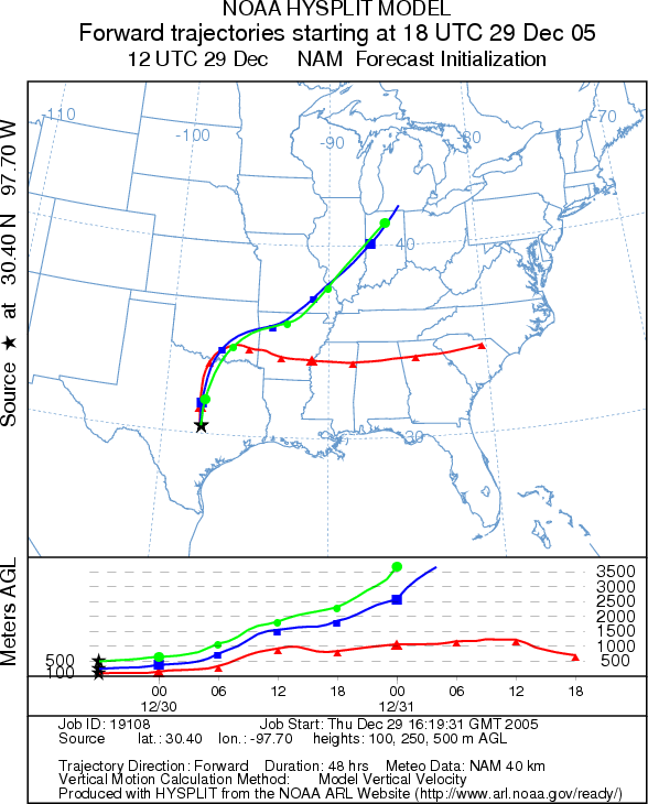
JUNCTION
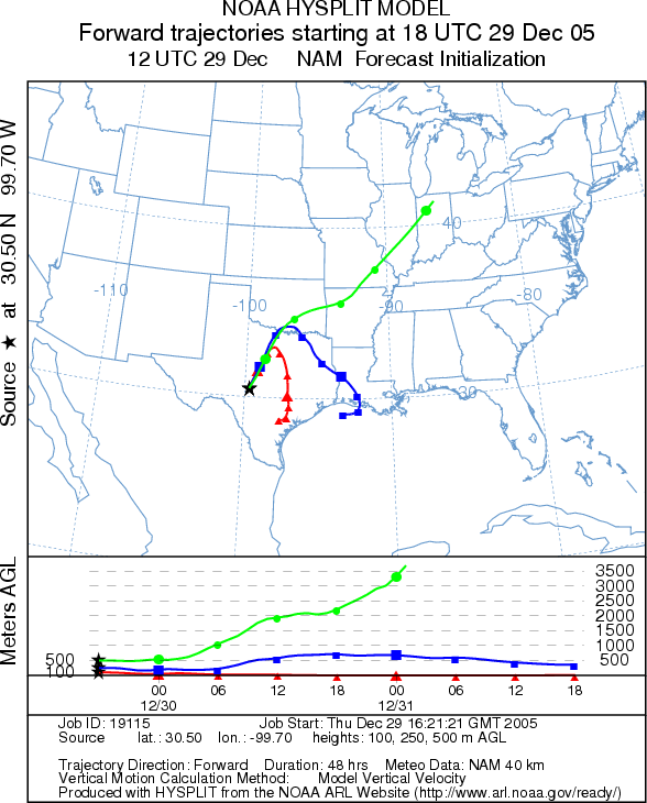
SAN ANGELO
Prepared by: Estelle
Levetin (Faculty of Biological
Science, The University
of Tulsa, 600 S. College, Tulsa, OK 74104) in conjunction with Peter K Van de Water. This
forecast gives the anticipated future track of released Mountain Cedar pollen, weather conditions over the region
and along the forecast pathway, and an estimated time of arrival for various metropolitan areas.
Questions: Aerobiology Lab e-mail: pollen@utulsa.edu
Return to Forecasting Home Page