The University of Tulsa
Mountain Cedar Pollen Forecast
Metropolitan Area |
Exposure Risk |
|
Oklahoma City |
Low |
|
Tulsa |
Low |
|
St. Louis MO |
Low |
Date Issued: 30 Dec 2005
Mountain Cedar Location(s): Arbuckle Mountains, OK
Regional Weather: Friday
and Saturday, Dec 30 and 31. TX/OK:
A weak cold front continues to move across the region bringing some high clouds to the south but with little chance
of rain today and tomorrow. Another low pressure will form to the west overnight and begin to move eastward on
Saturday. Winds will be from the north to northwest during the beginning of today, but as the cold front drops
further south into Texas they will come around blowing from the south to the north. To the north skies will be
relatively clear to the west with clouds developing toward the Mississippi River valley back across Arkansas and
into eastern Oklahoma. Temperatures will be in the lower to mid 60s and relatively dry conditions as humidity
will be less than 40%, drier to the west, during the day both today and tomorrow. Nighttime temperatures will be
in the mid to upper 30s. Tomorrow, temperatures will warm by about 5 degrees and will continue to be relatively
dry. In Texas, high clouds will be present with daytime highs in the low to mid 70s along the southern edge of
the Edwards Plateau cooling to the mid 60s to the north near Dallas both today and tomorrow. Nighttime temperatures
will remain above the freezing mark, in the mid to upper 40s eastward and the upper 30s to the west. Relative
humidity will continue to be low during the day with little chance of precipitation throughout the region. Temperatures
across Texas will remain about the same to slightly cooler on Saturday. Daytime winds will show speeds between
10 and 20 miles/hour, decreasing overnight, switching from a northerly to a northerly direction late Friday.
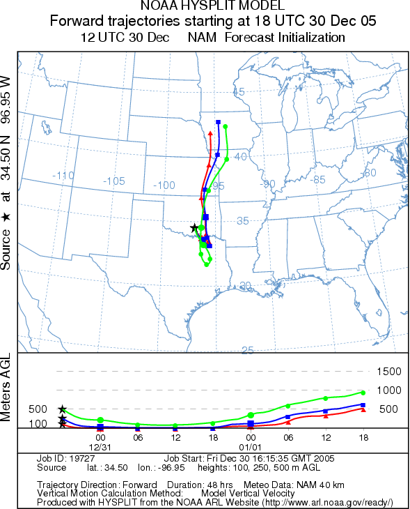
Trajectory weather: The air mass trajectories move southward
from the Arbuckle Mountains over northeastern Texas then loop northward toward the upper Midwest late today and
tomorrow. The trajectories are associated with sinking atmospheric characteristics over the next 24 hours, then
begin to rise as they move towards a low pressure system to the north. These conditions are poor for pollen entrainment
and travel away from the population in southern Oklahoma. If the Arbuckle populations are releasing pollen, the
overall good weather and atmospheric characteristics provide good conditions for downwind dispersal, but with sinking
atmospheric conditions dispersal should be limited to the immediate area.
OUTLOOK: *** Low threat *** Conditions are
good for the initiation of pollen release today and tomorrow. However, because the severe drought throughout the
region has delayed the pollen season, it is unclear if the trees have begun to shed pollen at this site. At this
time we do not have confirmation that these trees have started to pollinate. If they are beginning to pollinate,
the early date of the pollen season should result in modest amount being available for entrainment and travel.
However, poor atmospheric conditions indicates dispersal will be very limited
Trajectory Start (s) (shown by black
star on map): Sulfur, OK.
Prepared by: Estelle
Levetin (Faculty
of Biological Science, The University of Tulsa, 600 S. College, Tulsa, OK 74104) in conjunction with Peter K Van de Water.
This forecast gives the anticipated future track of released Mountain Cedar pollen, weather conditions over the
region and along the forecast pathway, and an estimated time of arrival for various metropolitan areas.
Questions: Aerobiology Lab e-mail: pollen@utulsa.edu
Return to Forecasting Home Page