The University of Tulsa
Mountain Cedar Pollen Forecast
Metropolitan Area |
Exposure Risk |
|
Dallas/Fort Worth |
Moderate |
|
Austin |
Moderate |
|
San Antonio |
Moderate |
Date Issued: 30 December 2005
Mountain Cedar Location(s): Edwards Plateau, Texas
Regional Weather: Friday
and Saturday, Dec 30 and 31. TX/OK:
A weak cold front continues to move across the region bringing some high clouds to the south but with little chance
of rain today and tomorrow. Another low pressure will form to the west overnight and begin to move eastward on
Saturday. Winds will be from the north to northwest during the beginning of today, but as the cold front drops
further south into Texas they will come around blowing from the south to the north. To the north skies will be
relatively clear to the west with clouds developing toward the Mississippi River valley back across Arkansas and
into eastern Oklahoma. Temperatures will be in the lower to mid 60s and relatively dry conditions as humidity
will be less than 40%, drier to the west, during the day both today and tomorrow. Nighttime temperatures will be
in the mid to upper 30s. Tomorrow, temperatures will warm by about 5 degrees and will continue to be relatively
dry. In Texas, high clouds will be present with daytime highs in the low to mid 70s along the southern edge of
the Edwards Plateau cooling to the mid 60s to the north near Dallas both today and tomorrow. Nighttime temperatures
will remain above the freezing mark, in the mid to upper 40s eastward and the upper 30s to the west. Relative
humidity will continue to be low during the day with little chance of precipitation throughout the region. Temperatures
across Texas will remain about the same to slightly cooler on Saturday. Daytime winds will show speeds between
10 and 20 miles/hour, decreasing overnight, switching from a northerly to a northerly direction late Friday.
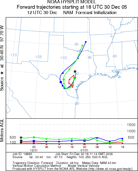
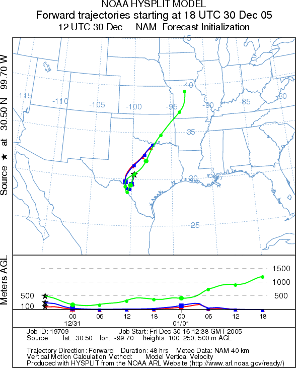
Trajectory weather: The air mass trajectories from the Edwards
Plateau Texas move southward today, then as the cold front passes southward into the Gulf of Mexico the trajectories
move in a more northerly direction as winds come about moving from the south to north. The trajectories on the
eastern edge of the Plateau follow the movement of the upper mid-west low pressure northeast whereas those to the
west show turn towards the southeast at the lowest elevations. The trajectories from the western side of the Edwards
Plateau switch sooner than to the east. Sinking atmospheric conditions characteristic of all of the trajectories
at the lowest elevation are poor characteristics for entrainment and travel therefore any pollen released and entrained
into the atmosphere should remain relatively close to the source as movement along the ground leads to high levels
of impaction on surface vegetation and sedimentation. Pollen reaching upper atmospheric levels, 250m and higher,
may move to the north into southern and eastern Oklahoma. However the long travel path should significantly reduce
any pollen concentrations within these air masses Weather conditions will be good for pollen release (see outlook)
with temperatures in the upper 60s to low 70s today and tomorrow, clearing skies and low relative humidity. Nighttime
temperatures will remain above freezing in the low to mid 40s to the east and low 40s in the west.
OUTLOOK: *** Low-Moderate threat *** although temperatures are good for pollen release, the severe drought throughout
the region has delayed the pollen season. At this time limited pollen counts from the region suggest pollination
is beginning but is not significant. However, atmospheric pollen counts from the Austin and Waco are showing increases
in Cedar pollen. These conditions may affect those with extreme sensitivities. Therefore, if pollen release has
started in localized areas, conditions are good for pollen release and the threat is elevated to Moderate within
these regions.
Trajectory Start (s) (shown by *
on map): Austin, TX; Junction, TX; San Angelo, TX.
AUSTIN
JUNCTION
SAN ANGELO
Prepared by: Estelle
Levetin (Faculty of Biological
Science, The University
of Tulsa, 600 S. College, Tulsa, OK 74104) in conjunction with Peter K Van de Water. This forecast
gives the anticipated future track of released Mountain Cedar pollen, weather conditions over the region and along
the forecast pathway, and an estimated time of arrival for various metropolitan areas.
Questions: Aerobiology Lab e-mail: pollen@utulsa.edu
Return to Forecasting Home Page