The University of Tulsa
Mountain Cedar Pollen Forecast
Metropolitan Area |
Exposure Risk |
|
Oklahoma City |
Low |
|
Tulsa |
Low |
|
St. Louis MO |
Low |
Date Issued: 27 December 2007
Mountain Cedar Location(s): Arbuckle Mountains, OK
Regional Weather: Thursday, December 27 TX/OK:
The weather today will be impacted by the position of the jet stream just north of the Texas Panhandle and Oklahoma.
Overall conditions in Oklahoma will be cool with central Oklahoma and northward in the 30s and closer to the Texas
border in the upper 30s to lower 40s. Skies will be mostly cloudy with 10 to 15 mph winds from the east to southeast.
Tonight snow and rain to the north and rain towards Texas will develop (70% to 30% north to south) as temperatures
range from the upper 20s in Oklahoma City to the lower 30s in Ardmore, south of the Arbuckle Mountains. Winds will
continue to be from the east to southeast at 10 to 15 mph. Tomorrow skies will remain partly cloudy with temperatures,
ranging from the upper 30s to mid-40s in Oklahoma. Winds will switch from the predominant easterly direction to
a northwest wind at 10 to 15 mph.. In Texas, temperatures will warm towards the south with sunny skies and predicted
highs in the mid to lower 60s across and around the Edwards Plateau. Winds will be strong, building towards the
afternoon and evening with portions of the Plateau experiencing 20 to 30 mph winds from the south to southeast.
Overnight, skies will become partly to mostly cloudy with temperatures from the lower to mid 30s into the lower
40s. Winds will continue to be strong with gusts between 25 and 30 mph. Winds start from the southeast, but will
shift overnight to a west and northwest direction. Friday's weather will return temperatures to slightly lower
levels in the upper 50s and lower 60s. Skies will clear to sunny conditions with winds remaining strong from the
northwest to north.
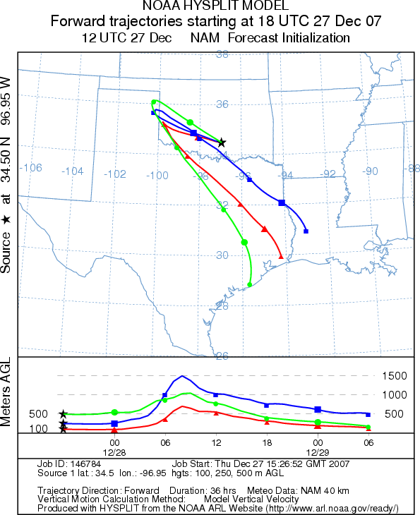
Trajectory weather: The air mass trajectories move from the Edwards Plateau north-northeast quickly over
all but the panhandle of Oklahoma. Populations in the Arbuckle Mountains will be more influenced by the overall
trend of the southeastern winds that then abruptly turn to a northwestern direction bringing the trajectories back
to the southeast. Overnight increasing clouds and a heightened chance of precipitation to the north will dampen
any significant pollen movement over the area. In addition, winds shift to the northwest causing the trajectories
to move back towards the southeast. Wind characteristics show a relatively buoyant atmosphere suggesting good characteristics
entrainment of any pollen that is released and possible long distance travel. However temperatures at the source
area in the Arbuckle Mountains are too cold for significant pollen release.
OUTLOOK: *** Low threat today *** Temperatures will be low with significant
humidity and the possibilities of showers tonight, thus poor conditions for pollen release in southern Oklahoma
today. Conditions are better further south over the Edwards Plateau with clearer skies and temperatures in the
upper 50s to low 60s. Throughout the region strong winds from the south and southeast will be building overnight
and switching to north-northeast. If pollen is entrained and buoyed upwards in the atmosphere pollen may be carried
further north into Missouri impacting the St. Louis area. The trajectories show that the northerly winds will move
trajectories rapidly off the Edwards Plateau directly over Oklahoma. However, increasing clouds with a potential
of showers along the eastern edge of the Edwards Plateau and to the north will dampen conditions for pollen release,
movement, and long distance travel. Poor conditions today, with better conditions tomorrow result in a cautious
forecast with the potential of significant pollen levels spreading north of the main Juniperus asheii population
depending upon the timing of the increase in humidity and the development of wetter conditions.
Trajectory Start (s) (shown by black
star on map): Sulfur, OK.
Prepared by: Estelle
Levetin (Faculty of Biological
Science, The University
of Tulsa, 600 S. College, Tulsa, OK 74104) and Peter K Van de Water
(Department of Earth and Environmental Science, California State University Fresno, 2576 East San Ramon Avenue,
M/S ST24, Fresno CA 93740-8039). This forecast gives the anticipated future track of released Mountain
Cedar pollen, weather conditions over the region and along the forecast pathway, and an estimated time of arrival
for various metropolitan areas.
Questions: Aerobiology Lab e-mail: pollen@utulsa.edu
Return to Forecasting Home Page