Metropolitan Area |
Exposure Risk |
|
Dallas/Fort Worth |
Low to Moderate/Low |
|
Austin |
High/Moderate |
|
San Antonio |
High/Moderate |
Date Issued: 31 December 2007
Mountain Cedar Location(s): Edwards Plateau, Texas
Regional Weather: Monday and Tuesday, Dec 31, 2007 and
Jan1, 2008 TX/OK: The weather today and tomorrow will be influenced by cold air sagging into the southern
Great Plains bringing colder temperatures and windy northern winds. Temperatures in central Oklahoma will be in
the upper 40s today with mid to lower 50s southward towards Texas. Skies will be partly cloudy to the north with
sunnier skies southward. Winds will be strongly from the northwest with sustained winds of 15 to 30 mph and gusts
above that level. Overnight, temperatures will be in the mid to lower 20s as skies clear. Winds will remain strong,
10 to 15 mph, from the northwest. Warmer temperatures and sunny skies will rule throughout Texas with the highs
in the upper 50s to lower 60s over the Edwards Plateau, and into the upper 60s along the southern and eastern Edwards
Plateau communities of Austin and San Antonio. Winds will be strong building during the afternoon from the northwest
over the Plateau and from the west in the edge communities. Skies will stay mostly clear tonight with temperatures
hovering around 20 across the Edwards Plateau rising to just above freezing at lower elevations along the edge
of the Plateau. Winds will continue to me moderate, 5 to 15 mph, from the north as cold air moves over the region.
On Tuesday, sunny conditions will return to the region but with colder temperatures. In Oklahoma highs will only
reach into the mid 30s with low 40s along the southern border with Texas Winds will increase during the day to
10/20 mph from the northwest. In Texas, high temperatures fall from today's high by 5-10 degrees into the upper
40's to low 50's across the region. Winds will increase during the day to 10 to 20 mph and will remain from the
North. Tuesday night will continue to be very cold as low temperatures hover near the teens over the Plateau and
into the mid to low 20s around the edge of the Edwards Plateau. Winds will continue from the north at 5 to 10
mph.
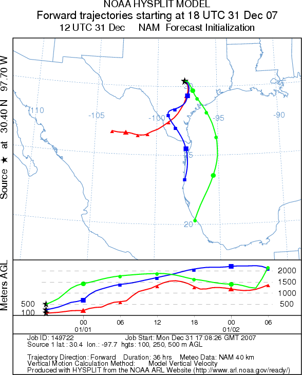
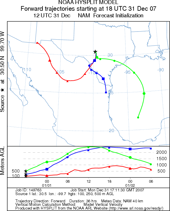
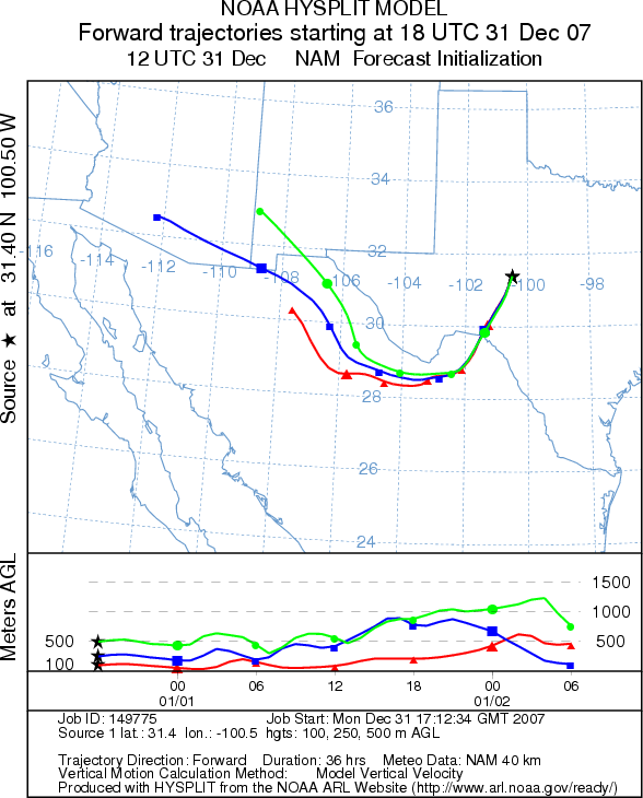
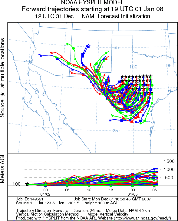
Trajectory weather: The air mass trajectories from the Edwards Plateau Texas move to the south and then
southwest over the next 24 hours from the primary area with Juniperus ashei trees out over southern Texas and eventually
into Mexico. The trajectories are associated with buoyant air rising along the trajectory as colder air flows
in, under the current air mass. Conditions will be moderate for release and good for pollen entrainment and long-distance
travel today. The winds from the Arbuckle Mountains move south as along with the cold air, however, the trajectories
show sinking atmospheric conditions that are not good for pollen entrainment and travel.
On Tuesday winds will continue to be from the north to northwest with colder temperatures across the region. Trajectories
from the Edwards Plateau will move more towards the south then loop towards the west moving into the Big Bend region,
onto Mexico and then towards New Mexico. Atmospheric conditions are stable to sinking as cold air invades the
region. Overall conditions for pollen release will be poor as temperatures will be in the mid to low 40's for
highs across the Plateau and just getting into the 50's in the communities along the eastern and southern Plateau
edge. Poor conditions will also occur in Oklahoma as high temperatures will only reach the mid 30's to just above
40 with trajectories moving to the southeast.
.
OUTLOOK: *** Moderate to High threat today, Good conditions
for pollen release; Low threat tomorrow, Poor conditions for pollen release *** Temperatures will reach the mid 50s to upper 60s along the edge of the Edwards Plateau
today but will decline rapidly as cold air moves in from the north. Predominantly, strong winds will carry any
pollen released from southern Oklahoma southward towards eastern Texas and eventually out over the Gulf of Mexico.
In Texas trajectories will predominantly move towards the south then be pushed, initially at the lower levels,
towards the west. Conditions today are good, but tomorrow will be marginal and degrade with very cold air sagging
into the southern Great Plains. Warm temperatures and lower humidity today will be good for pollen release on
the Edwards Plateau, and with high predicted winds movement of pollen into south Texas is expected. Potentially
significant pollen dispersion downwind will put allergy sufferers in southern Texas at risk today, but cold temperatures
and poor pollination as well as entrainment and travel conditions tomorrow should lessen the impact on allergy
sufferers tomorrow.
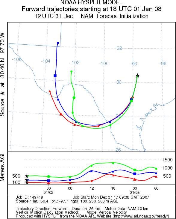
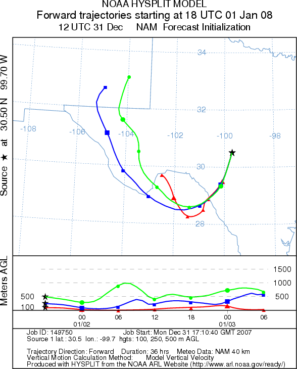
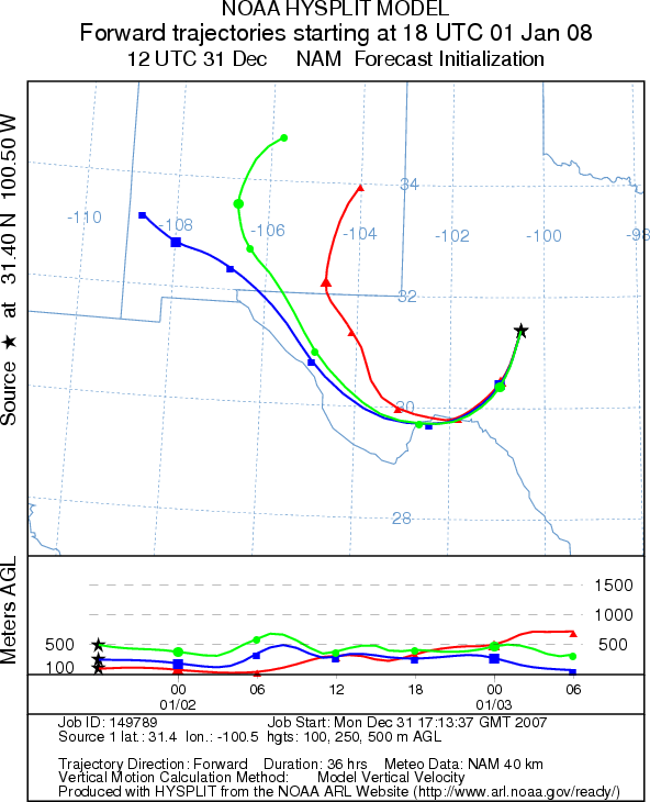
Trajectory Start (s) (shown by *
on map): Austin, TX; Junction, TX; San Angelo, TX.
AUSTIN (MONDAY)
JUNCTION (MONDAY)
SAN ANGELO (MONDAY)
EDWARDS PLATEAU COMPOSITE (MONDAY)
AUSTIN (TUESDAY)
JUNCTION (TUESDAY)
SAN ANGELO (TUESDAY)
EDWARDS PLATEAU COMPOSITE (TUESDAY)
Prepared by: Estelle
Levetin (Faculty of Biological
Science, The University
of Tulsa, 600 S. College, Tulsa, OK 74104) and ) and Peter K Van de Water (Department of Earth and
Environmental Science, California State University Fresno, 2576 East San Ramon Avenue, M/S ST24, Fresno CA 93740-8039).
This forecast gives the anticipated future track of released Mountain Cedar pollen, weather conditions over the
region and along the forecast pathway, and an estimated time of arrival for various metropolitan areas.
Questions: Aerobiology Lab e-mail: pollen@utulsa.edu
Return to Forecasting Home Page