The University of Tulsa
Mountain Cedar Pollen Forecast
Metropolitan Area |
Exposure Risk |
|
Dallas/Fort Worth |
Low |
|
Austin |
Low |
|
San Antonio |
Low |
Date Issued: 22 December 2008
Mountain Cedar Location(s): Edwards Plateau, Texas
Regional Weather: Monday, December 22 TX/OK:
A cold front reached down across the southern Great Plains yesterday and the cool temperatures will continue to
dominate the region today. Winds will continue to be moderate from the southeast this morning shifting to a more
easterly direction. The western portion of the Edwards Plateau will start more northeasterly then shift towards
the southeast latter in the day. As warmer, moister air is pulled in from the south today the chance of rain and
drizzle will continue to grow during the day across the region. Overnight temperatures will remain in the mid-
to low 30s with east to southeast and southerly winds continuing. In many areas, lingering cold temperatures may
result in limited freezing rain. Tomorrow temperatures will warm by upwards of 20 to 30 degrees with most of the
southern areas in the mid-60s and in the mid-50s to the north. Winds will remain moderate from the south. Temperatures
overnight on Tuesday will remain moderate to the south, in the mid-50s to low 60s. To the north low temperatures
will return to the 30s.
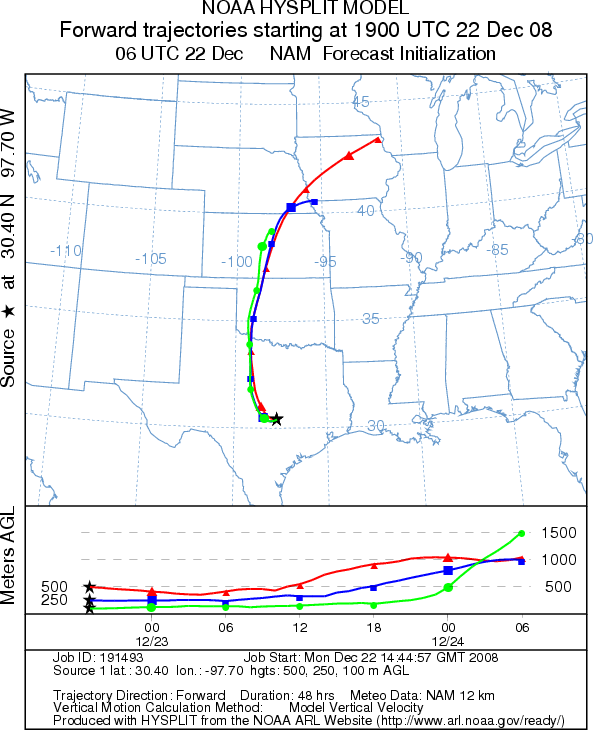
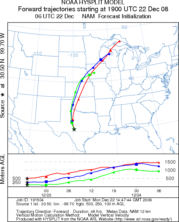
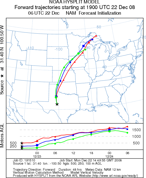
Trajectory weather: Trajectories from the Edwards Plateau move to the north as southerly winds return to
the region this afternoon. Partly to mostly cloudy today, high temperatures will be in the mid 30s to low 40s as
the lingering effects of this weekends cold front remain in the area. As moist air starts to push in from the
south, the chance of rain and freezing rain in some areas will occur today. High temperatures are expected in the
upper 30s to lower 40s throughout the central Texas region. High levels of humidity and cold temperatures should
retard and pollen release. Tonight the chance of rain and drizzle increases across the region. Temperatures will
remain in the mid-30s. Winds will be from the east during the day shifting to the southeast this afternoon or evening.
Tomorrow, morning fog will give way to cloudy skies as temperatures warm significantly into the upper 50s to mid-60s.
Winds will shift out of the south and become moderate. However, with the warmer and moister air the chance of precipitation
on Tuesday and Tuesday night will continue. Temperatures Tuesday night will remain warm in the mid-50s.
OUTLOOK: *** Low Threat ***unfavorable conditions for pollen release
today. The annual beginning of Juniperus ashei pollen release is starting to be confirmed with recorded
values over the weekend occurring to the south on the Edwards Plateau of central Texas. Wet and cold conditions
today should retard pollen release, but warming conditions tomorrow may result in pollen dissemination. Because
this is the initial indication of Juniperus ashei pollen release, residents throughout southern plains should
brace themselves for the upcoming pollination season.
Trajectory Start (s) (shown by *
on map): Austin, TX; Junction, TX; San Angelo, TX.
AUSTIN
JUNCTION
SAN ANGELO
Prepared by: Estelle
Levetin (Faculty of Biological
Science, The University
of Tulsa, 800 S. Tucker Dr., Tulsa, OK 74104) and ) and Peter K Van de Water (Department
of Earth and Environmental Science, California State University Fresno, 2576 East San Ramon Avenue, M/S ST24, Fresno
CA 93740-8039). This forecast gives the anticipated future track of released Mountain Cedar pollen, weather conditions
over the region and along the forecast pathway, and an estimated time of arrival for various metropolitan areas.
Questions: Aerobiology Lab e-mail: pollen@utulsa.edu
Return to Forecasting Home Page