The University of Tulsa
Mountain Cedar Pollen Forecast
Metropolitan Area |
Exposure Risk |
|
Oklahoma City |
Low |
|
Tulsa |
Low |
|
St. Louis MO |
Low |
Date Issued: 23 December 2008
Mountain Cedar Location(s): Arbuckle Mountains, OK
Regional Weather: Tuesday, December 23 - TX/OK:
Cloudy weather and cool conditions will occur across the Oklahoma region with warming temperatures to the south.
The northern region this morning may experience freezing drizzle this morning warming into the low 40s during the
day. Winds will be moderate to strong and from the south with gusty conditions this afternoon. Today, southern
Oklahoma expects a 35% chance of rain diminishing to 20% tonight. In central Texas, similar conditions will occur
around the eastern and southern edges of the Edwards Plateau. However, temperatures will be warmer and thus only
drizzle and fog is forecast and the potential of freezing conditions is diminished. Temperatures in the western
part of the Plateau will climb into the mid to lower 60s. On the eastern part of the Edwards Plateau, mostly cloudy
conditions will move towards partly cloudy conditions with temperatures in the mid-40s to low 50s. Winds will be
from the south today at 10-20 mph then shift overnight out of the west. Tomorrow conditions will continue to warm
region wide, with partly cloudy conditions to the north. Temperatures will warm into the low 50s around the Arbuckle
Mountains. Winds will be moderate and shift to out of the north then swing back around to the east overnight on
Wednesday. In Texas, mostly sunny conditions will occur on Wednesday with temperatures climbing into the low 70s
around the edge of the Edwards Plateau and into the 60s on the Edwards Plateau. Winds will swirl during the day
from the northwest to north to northeast over night.
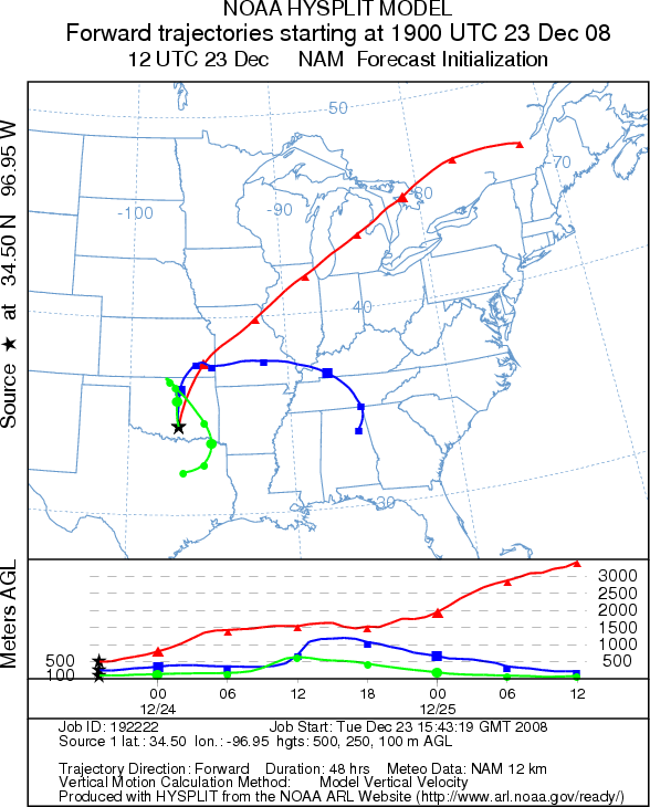
Trajectory weather: Partly to mostly cloudy today, with the potential of freezing rain in the morning. High temperatures will eventually reach the low 40s. There is a 35% chance of precipitation today dropping to 20% tonight. Winds will be moderate from the south, but with gusts of up to 35 mph. Overnight winds will shift out of the north for tomorrow and then rotate eastward tomorrow night. Significant warming will occur tomorrow with highs in the mid 50s. Skies will be opening up with only partly cloudy skies Wednesday and mostly clear skies on Wednesday night. Air mass trajectories move to the north today and then show variability at different altitudes. The upper level trajectories move to the northeast, while the trajectories at lower elevations curve back to the south.
OUTLOOK: *** Low Threat *** unfavorable conditions for pollen release today but more favorable conditions tomorrow. Significant winds from the south could carry any pollen entrained into the atmosphere significant distances as seen in the attached graphic. Whereas, the annual beginning of Juniperus ashei pollen release is confirmed with recorded values over the weekend south on the Edwards Plateau of central Texas. Wet and cool conditions with a chance of precipitation today and tonight should retard pollen release. However, warming and drying conditions tomorrow may result in pollen dissemination. Because this is the initial indication of Juniperus ashei pollen release, residents throughout southern plains should brace themselves for the upcoming pollination season.
Trajectory Start (s) (shown by black
star on map): Sulfur, OK.
Prepared by: Estelle
Levetin
(Faculty
of Biological Science, The University of Tulsa, 800 S. Tucker Dr., Tulsa, OK 74104) and Peter
K Van de Water
(Department of Earth and Environmental Science, California State University Fresno, 2576 East San Ramon Avenue,
M/S ST24, Fresno CA 93740-8039). This forecast gives the anticipated future track of released Mountain Cedar pollen,
weather conditions over the region and along the forecast pathway, and an estimated time of arrival for various
metropolitan areas.
Questions: Aerobiology Lab e-mail: pollen@utulsa.edu
Return to Forecasting Home Page