The University of Tulsa
Mountain Cedar Pollen Forecast
WEDNESDAY
Metropolitan Area |
Exposure Risk |
|
Dallas/Fort Worth |
Low |
|
Austin |
High |
|
San Antonio |
High |
THURSDAY
Metropolitan Area |
Exposure Risk |
|
Dallas/Fort Worth |
Moderate to High |
|
Austin |
High |
|
San Antonio |
High |
Date Issued: 24 December 2008
Mountain Cedar Location(s): Edwards Plateau, Texas
Regional Weather: Wed and Thurs, December 24 and 25 -
TX/OK: Across the region conditions will be warming with partly cloudy skies today and increasing chance
of precipitation to the south along the edge of the Edwards Plateau in Texas. Across Oklahoma, winds will be light
and variable with temperatures in the 40s to the low 50s in southern Oklahoma today. Tonight, the lows will be
in the 30s with light and variable winds out of the east. Christmas day will bring partly to mostly cloudy skies
with warm temperatures and winds shifting out of the southeast to the south with increasing intensity towards Thursday
night into Friday. By Thursday night the chance of precipitation will begin to increase. To the south in Texas,
the Edwards Plateau will warm into the 60s and low 70s today. Winds will be light to moderate from the northeast
today shifting to the southeast over night and eventually to the south on Christmas day through Friday. Temperatures
on Christmas will continue to be warm in the 60s and 70s across the region. Thursday and Friday night low temperatures
will remain warm only dropping into the upper 50s to mid 60s. Winds will increase Thursday evening into Friday.
Starting on Thursday evening the chance of precipitation will begin to rise with a 30-40% chance occurring around
the Edwards Plateau by Friday.
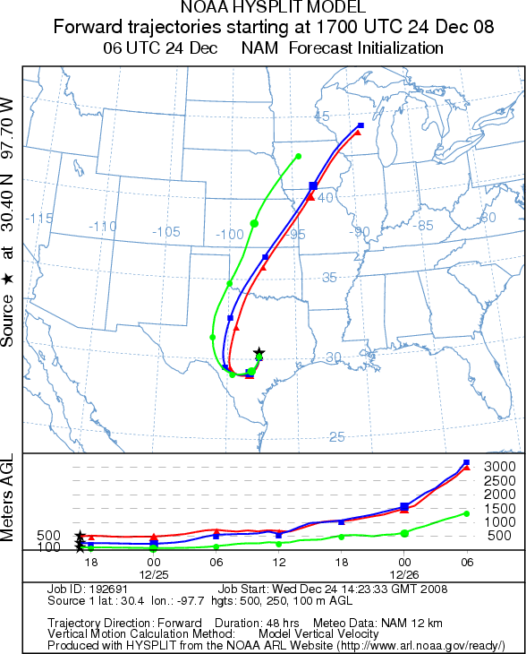
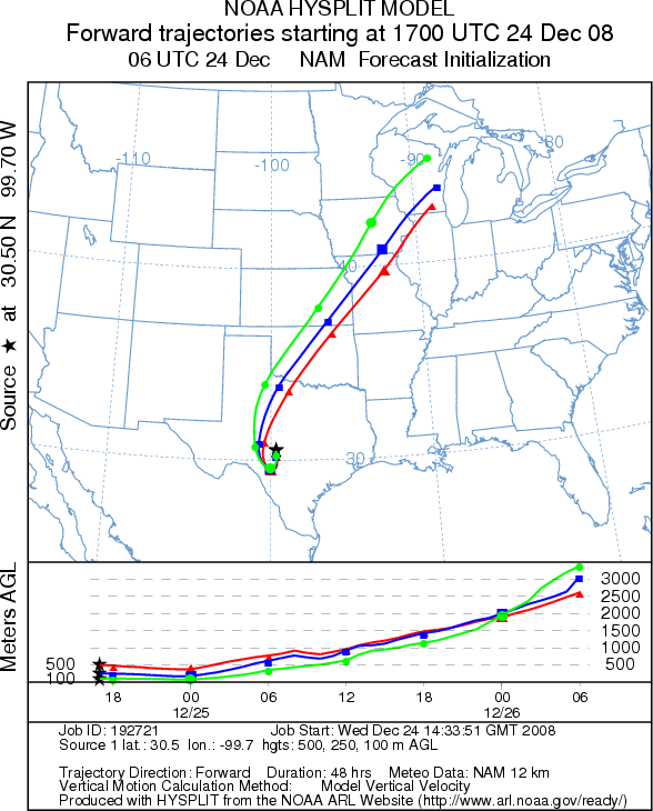
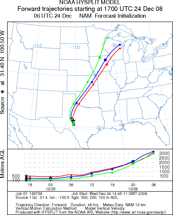
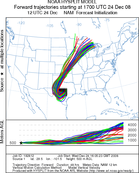
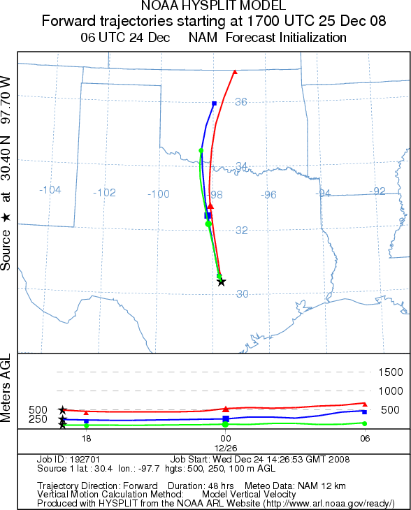
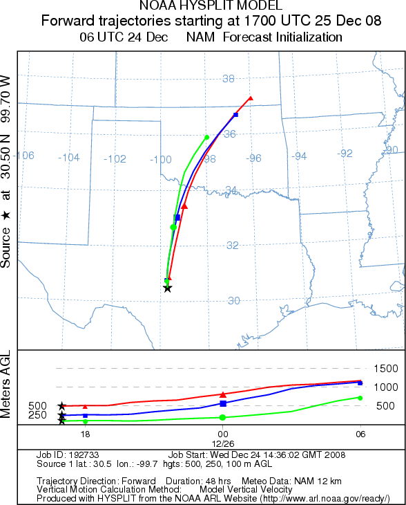
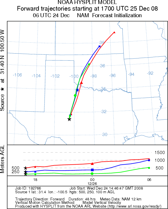
Trajectory weather: Clear to partly cloudy skies today, with warming conditions will occur across Texas. Most areas will see morning fog clearing to partly sunny skies around the edge of the Edwards Plateau and partly cloudy skies across the Plateau itself. Winds will be light to moderate, beginning from the north and shifting towards a dominant southerly direction over the next day. The populated areas along the eastern and southern edges of the Edwards Plateau will see winds that should push any entrained pollen to the southwest. Conditions in the tree population in central Texas should be conducive for the release of pollen today and even more so tomorrow. On Friday, the increasing chance of precipitation should keep humidity levels high thus potentially dampening any release. Air mass trajectories indicate that pollen released today will move slowly to the south and then circle towards the west then begin to move northward as the winds shift tomorrow. Tomorrow as wind speeds increase any entrained pollen should move northward across north central Texas and onto Oklahoma, eventually moving towards the upper mid-west.
OUTLOOK: *** Moderate to High Threat *** favorable conditions for pollen release today with more favorable conditions tomorrow. Warming conditions and an overall drying from recent wet conditions should lead to favorable conditions for pollen release today and tomorrow. Light to moderate winds with relatively stable conditions suggest that any pollen released today should remain close to the Edwards Plateau. However for tomorrow winds will begin to pick-up and the atmosphere will be increasingly light and buoyant, conditions associated with pollen entrainment and transport. Coupled with warming conditions the potential for pollen spread tomorrow is much greater. Winds from the south will carry any pollen entrained into the atmosphere northward across an area west of Dallas/Fort Worth and east of Amarillo, before moving northward across west central Oklahoma. Because the annual beginning of the Juniperus ashei pollination season is just starting, the total number of pollen cones ready to disseminate their pollen will be proportionately small. However, the next couple of days provide the best conditions yet, for long-distance pollen dispersal. Because this is the initial indication of Juniperus ashei pollen release, residents throughout southern plains should brace themselves for the upcoming pollination season.
Trajectory Start (s) (shown by *
on map): Austin, TX; Junction, TX; San Angelo, TX.
WEDNESDAY
AUSTIN
JUNCTION
SAN ANGELO
EDWARDS PLATEAU COMPOSITE
THURSDAY
AUSTIN
JUNCTION
SAN ANGELO
Prepared by: Estelle
Levetin (Faculty of Biological
Science, The University
of Tulsa, 800 S. Tucker Dr., Tulsa, OK 74104) and ) and Peter K Van de Water (Department
of Earth and Environmental Science, California State University Fresno, 2576 East San Ramon Avenue, M/S ST24, Fresno
CA 93740-8039). This forecast gives the anticipated future track of released Mountain Cedar pollen, weather conditions
over the region and along the forecast pathway, and an estimated time of arrival for various metropolitan areas.
Questions: Aerobiology Lab e-mail: pollen@utulsa.edu
Return to Forecasting Home Page