The University of Tulsa
Mountain Cedar Pollen Forecast
Metropolitan Area |
Exposure Risk |
|
Oklahoma City |
Moderate |
|
Tulsa |
Moderate |
|
St. Louis MO |
Low to Moderate |
Date Issued: 26 December 2008
Mountain Cedar Location(s): Arbuckle Mountains, OK
Regional Weather: Friday, December 26 - TX/OK:
Across the region conditions will be partly to mostly cloudy this morning with clearing and a partly sunny afternoon
in the western portions of the region. Conditions across the region will be warming with temperatures in the 60s
to 70s to the north and near 80 along the southern edge of the Edwards Plateau. Winds will be moderate to strong
from the south throughout the region with the air trajectories all moving into the central and northern Great Plains
over the next 24 to 48 hours. Tonight, will become mostly cloudy with an increasing chance of thunderstorms. Temperatures
will remain warm with lows in the 50s and 60s and the moderate to strong winds from the south will continue. Saturday
will continue with cloudy skies, clearing in the afternoon but with an early morning chance of thunderstorms across
the region. High temperatures on Saturday will moderate to the lower 60s and upper 50s as colder air moves into
the region. The winds on Saturday will begin from the south but start to shift during the day to a westerly direction.
Low temperatures on Saturday night will return back to the 30s and lower.
Trajectory weather: Mostly cloudy skies this morning with the chance of drizzle and high humidity. High
temperatures will be in the mid 70s but with an increasing chance of thunderstorms going into the evening hours.
Winds will be moderately strong from the south (15 -20 mph). Tonight will have an increasing chance of thunderstorms.
Temperatures tomorrow will be in the mid-60s declining to the mid-30s tomorrow night. Winds will shift to a westerly
direction on Saturday. Air mass trajectories move to the north, northeast over Oklahoma and eastern Kansas. The
atmosphere appears to be buoyant and with moderate wind speeds, both conditions conducive to pollen entrainment
and travel.
OUTLOOK: *** Moderate Threat *** mostly favorable conditions for pollen
release today with less favorable conditions tomorrow. Warming temperatures with high humidity gives mixed
conditions for pollen release today. Increased chance of precipitation tonight and into Saturday morning may impact
potential pollen shed tomorrow. Moderate to strong winds from the south, along with a buoyant atmosphere are conditions
that often lead to significant deposition of pollen downwind. Winds from the south will carry any pollen entrained
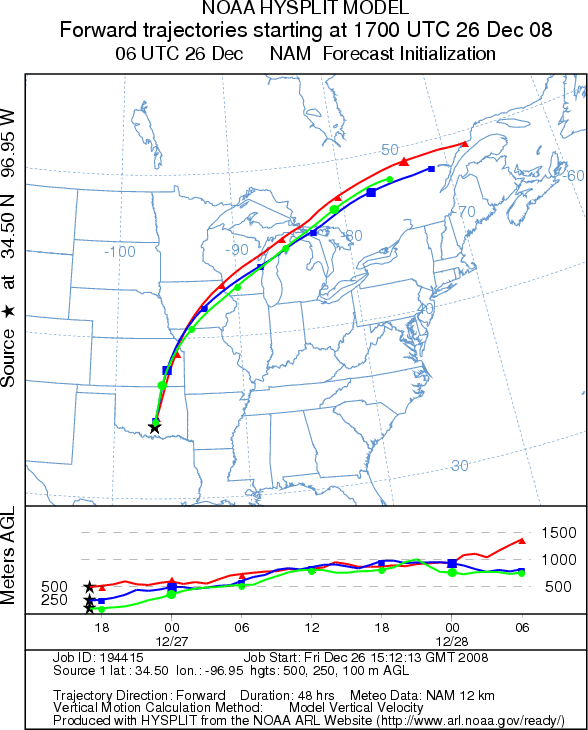
from Texas into the atmosphere northward across central Oklahoma. Analysis of the wind patterns over the next 48
hours shows a consistent wind direction resulting in any entrained pollen moving in the same general area outlined
in the figure below. Because the annual beginning of the Juniperus ashei pollination season is just starting, the
total number of pollen cones ready to disseminate their pollen will be proportionately small but increasing on
a daily basis. However, the next couple of days provide the best conditions yet, for long-distance pollen dispersal.
Because this is the initial indication of Juniperus ashei pollen release, residents throughout southern plains
should brace themselves for the upcoming pollination season.
Trajectory Start (s) (shown by black
star on map): Sulfur, OK.
Prepared by: Estelle
Levetin
(Faculty
of Biological Science, The University of Tulsa, 800 S. Tucker Dr., Tulsa, OK 74104) and Peter
K Van de Water
(Department of Earth and Environmental Science, California State University Fresno, 2576 East San Ramon Avenue,
M/S ST24, Fresno CA 93740-8039). This forecast gives the anticipated future track of released Mountain Cedar pollen,
weather conditions over the region and along the forecast pathway, and an estimated time of arrival for various
metropolitan areas.
Questions: Aerobiology Lab e-mail: pollen@utulsa.edu
Return to Forecasting Home Page