The University of Tulsa
Mountain Cedar Pollen Forecast
SATURDAY
Metropolitan Area |
Exposure Risk |
|
Oklahoma City |
Low |
|
Tulsa |
Low |
|
St. Louis MO |
Low |
SUNDAY
Metropolitan Area |
Exposure Risk |
|
Oklahoma City |
Moderate |
|
Tulsa |
Moderate |
|
St. Louis MO |
Low |
Date Issued: 27 December 2008
Mountain Cedar Location(s): Arbuckle Mountains, OK
Regional Weather: Sat and Sun, Dec 27 and 28 - TX/OK:
Across the region a cold front is moving in from the northwest bringing the chance of thunderstorms and showers
ahead of it and cooler conditions with clearing skies behind it. The front will move through this morning and early
afternoon towards the south. Winds will be initially from the southern quadrants but then will shift towards the
northwest to west as the colder, denser air moves in. The initial movement of this weather system will generate
moderate to strong winds that will calm tomorrow into lighter conditions. In Oklahoma high temperatures today will
be early this morning, and then start to cool into the mid to upper 20s tonight. Much warmer and more humid conditions
will occur this morning around the Edwards Plateau today with cooling after the cold front moves through. Forecast
highs for these areas are in the 80s in San Antonio and upper 70s in Austin but dropping this afternoon into the
60s. On the Edward Plateau, the cooling will occur sooner from the northwest towards the southeast with low temperatures
tonight expected to be in the mid to lower 20's. Cloudy skies this morning will diminish and sunny clear skies
will become more common tonight and tomorrow. Overnight cooling tonight will signal and overall cooling for tomorrow
with temperatures across the region cooling by 5 to 15 degrees.
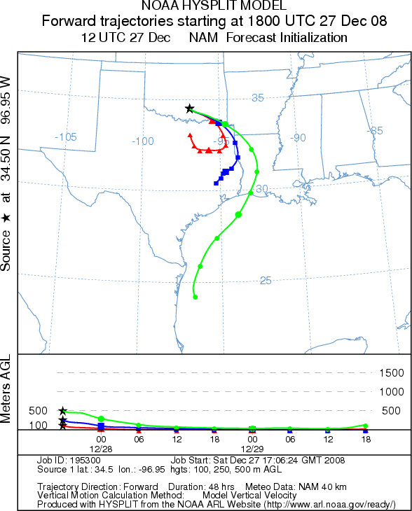
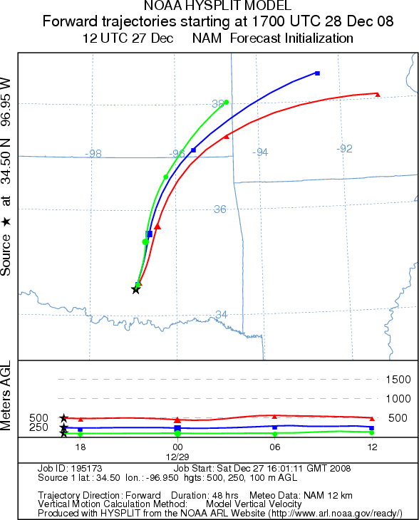
Trajectory weather: Partly sunny skies this morning will occur as the cold front passes to the east. High temperatures in the afternoon will be in the lower 50s but with moderate to strong winds from the northwest at 10 to 20 mph. Skies tonight will remain clear with temperatures falling into the upper 20s. Tomorrow temperatures will be in the upper 50s declining to the mid-30s tomorrow night. Winds will decrease tomorrow becoming light and variable then start to build from the south and southeast during the late afternoon and overnight. Air mass trajectories today move to the southeast and then curve back around tomorrow. Today's trajectories are influenced by the cold sinking air and show poor characteristics for entrainment. Tomorrow's trajectories move to the north as the winds return from the south.
OUTLOOK: *** Moderate Threat *** mixed conditions for pollen release. Drying conditions and moderate to strong winds today and tomorrow afternoon should result in favorable conditions for pollen release today and tomorrow. Clear skies and cold conditions may slightly delay release in the mornings, however sunny skies and moderate to strong winds are conditions that often lead to significant deposition of pollen downwind. However, the colder, denser air may mean that long-distance travel is somewhat restricted as the ability of the pollen to become entrained will be somewhat diminished. Winds from the north and northwest will carry any pollen entrained into the atmosphere southward towards the Edwards Plateau region. On Sunday winds will begin to rotate to a southerly direction moving pollen northward again.
Trajectory Start (s) (shown by black
star on map): Sulfur, OK.
SATURDAY
SUNDAY
Prepared by: Estelle
Levetin
(Faculty
of Biological Science, The University of Tulsa, 800 S. Tucker Dr., Tulsa, OK 74104) and Peter
K Van de Water
(Department of Earth and Environmental Science, California State University Fresno, 2576 East San Ramon Avenue,
M/S ST24, Fresno CA 93740-8039). This forecast gives the anticipated future track of released Mountain Cedar pollen,
weather conditions over the region and along the forecast pathway, and an estimated time of arrival for various
metropolitan areas.
Questions: Aerobiology Lab e-mail: pollen@utulsa.edu
Return to Forecasting Home Page