The University of Tulsa
Mountain Cedar Pollen Forecast
SATURDAY
Metropolitan Area |
Exposure Risk |
|
Dallas |
Low to Moderate |
|
Austin |
High |
|
San Antonio |
High |
SUNDAY
Metropolitan Area |
Exposure Risk |
|
Dallas |
Moderate |
|
Austin |
High |
|
San Antonio |
High |
Date Issued: 27 December 2008
Mountain Cedar Location(s): Edwards Plateau, Texas
Regional Weather: Sat and Sun, Dec 27 and 28 - TX/OK:
Across the region a cold front is moving in from the northwest bringing the chance of thunderstorms and showers
ahead of it and cooler conditions with clearing skies behind it. The front will move through this morning and early
afternoon towards the south. Winds will be initially from the southern quadrants but then will shift towards the
northwest to west as the colder, denser air moves in. The initial movement of this weather system will generate
moderate to strong winds that will calm tomorrow into lighter conditions. In Oklahoma high temperatures today will
be early this morning, and then start to cool into the mid to upper 20s tonight. Much warmer and more humid conditions
will occur this morning around the Edwards Plateau today with cooling after the cold front moves through. Forecast
highs for these areas are in the 80s in San Antonio and upper 70s in Austin but dropping this afternoon into the
60s. On the Edward Plateau, the cooling will occur sooner from the northwest towards the southeast with low temperatures
tonight expected to be in the mid to lower 20s. Cloudy skies this morning will diminish and sunny clear skies will
become more common tonight and tomorrow. Overnight cooling tonight will signal and overall cooling for tomorrow
with temperatures across the region cooling by 5 to 15 degrees.
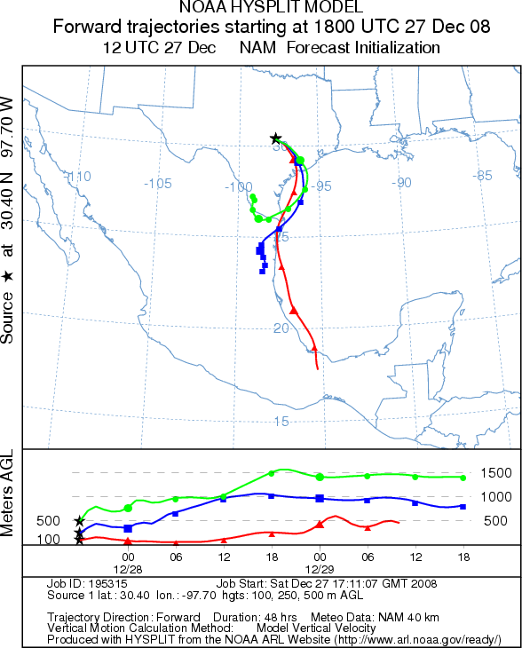
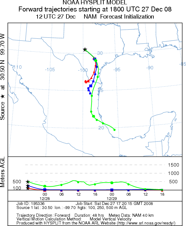
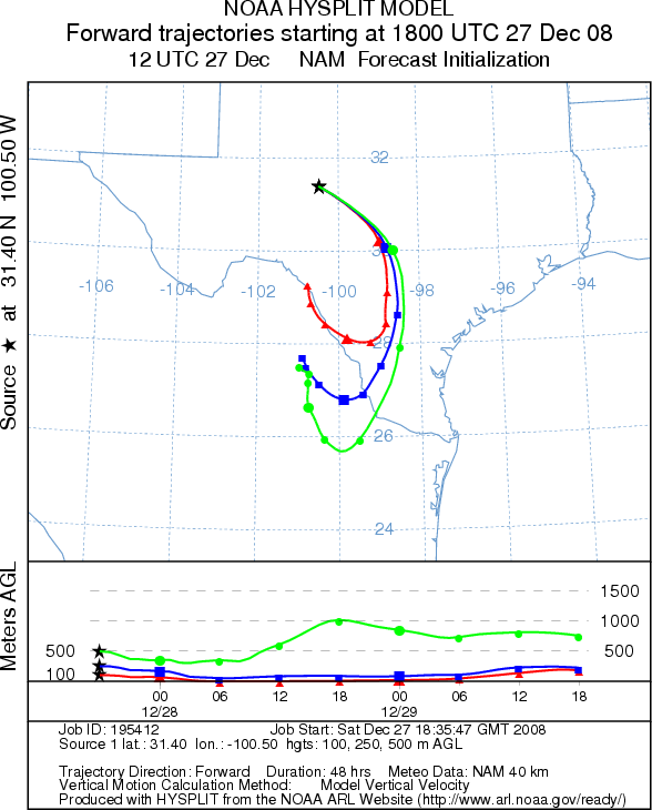
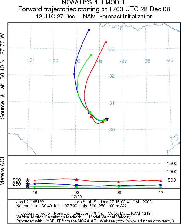
Trajectory weather: Partly sunny skies this morning will occur as the cold front passes to the east. A strong line of thunderstorms will occur as the front moves east. As it passes conditions will begin to clear and the atmosphere will begin to dry out. High temperatures around the Edwards Plateau will be in the mid 70s to 80s early on Saturday with moderate to strong winds from the south switching to the north by early afternoon. On the Edwards Plateau the shift will occur earlier with high temperatures only reaching the lower 60s. Skies tonight will clear with temperatures falling into the lower 20s on the Plateau and the mid 30s in the surrounding communities. Tomorrow temperatures will cool into the 60s region wide and tomorrow night low temperatures will return to the 20s and 30s. Winds will decrease tomorrow becoming light and variable remaining from the north and northwest. After the cold front moves in conditions for pollen release look good with drying and windy conditions. However, with the cooler atmosphere, conditions for entrainment and travel will not be optimal. Yet with moderate to strong wind speeds pollen entrainment and travel may be significant in the local to regional areas. Air mass trajectories from the Edwards Plateau move to the south, southeast today and back to the north tomorrow.
OUTLOOK: *** High Threat *** favorable conditions for pollen release today with favorable conditions tomorrow. Cooler conditions but with an overall drying of the atmosphere along with moderate to high wind speeds will result in favorable conditions for pollen release today and tomorrow and local concentrations should be high. Winds from the northwest will carry any pollen entrained into the atmosphere southward towards the Edwards Plateau area for trees shedding pollen in Oklahoma, and towards south Texas for the larger population that grows on the Edwards Plateau. Significant concentrations are expect in San Antonio towards the U.S.-Mexico Border area. Because the annual beginning of the Juniperus ashei pollination season has just started, the total number of pollen cones ready to disseminate their pollen is gaining in number. Today and tomorrow provide very good conditions, however the cooler denser air that is coming into the region may retard some of the entrainment for long-distance pollen dispersal. The occurrence of the highest pollen concentrations to date occurred in the Austin region, a High threat is being posted for the Plateau region and southward .
Trajectory Start (s) (shown by *
on map): Austin, TX; Junction, TX; San Angelo, TX.
SATURDAY
AUSTIN
JUNCTION
SAN ANGELO
EDWARDS PLATEAU COMPOSITE
SUNDAY
AUSTIN
JUNCTION
SAN ANGELO
Prepared by: Estelle
Levetin (Faculty of Biological
Science, The University
of Tulsa, 800 S. Tucker Dr., Tulsa, OK 74104) and ) and Peter K Van de Water (Department
of Earth and Environmental Science, California State University Fresno, 2576 East San Ramon Avenue, M/S ST24, Fresno
CA 93740-8039). This forecast gives the anticipated future track of released Mountain Cedar pollen, weather conditions
over the region and along the forecast pathway, and an estimated time of arrival for various metropolitan areas.
Questions: Aerobiology Lab e-mail: pollen@utulsa.edu
Return to Forecasting Home Page