The University of Tulsa
Mountain Cedar Pollen Forecast
Metropolitan Area |
Exposure Risk |
|
Dallas/Fort Worth |
High |
|
Austin |
High |
|
San Antonio |
High |
Date Issued: 29 December 2008
Mountain Cedar Location(s): Edwards Plateau, Texas
Regional Weather: Monday, December 29 - TX/OK:
Warm sunny skies are in store for the region today warming to even higher temperatures tomorrow. In Oklahoma
the southern area will be in the mid 60's with light and variable winds from the southwest. Conditions tonight
will remain clear with lows in the upper 30s and then clear sunny skies tomorrow with high temperatures in the
lower 70s. Winds tonight will remain light from 5 to 10 mph from the south. Tomorrow winds will pick-up and shift
to the southwest from 10 to 15 mph. Tuesday night mostly clear skies are expected with temperatures in the mid-30s.
Winds will shift from the southwest to the north as a week cold front pushes through. In Texas similar conditions
will prevail with sunny conditions toady and regional temperatures in the upper 60s. Light winds will be from
the south on the Edwards Plateau. In the surrounding communities, air will move off of the Plateau so light winds
from the north are expected in San Antonio and northwest winds in Austin. Tonight skies will remain clear with
temperatures in the low to mid 30s. Winds will increase slightly and become dominantly from the southwest, but
still light. Tomorrow will bring a regional warming as high temperatures reach into the lower 70s. Winds will
begin to pick up reaching moderate conditions and from the southwest. Tuesday night winds will begin to shift
as the week cold front moves through the region. Temperatures will reach the mid 30s once again and skies will
remain mostly clear.
Trajectory weather: Warm temperatures will occur region wide along with light to variable winds. The trajectories
show that at the ground surface the atmosphere will remain relatively stable thus moving at or near ground level
through the trees. Along the Edwards Plateau, winds will be light and variable in the morning and early afternoon.
As regional winds rise during the day the overall air mass trajectories will be towards the north and then northeast
(see matrix graphic below). All conditions look very favorable for pollen dispersal from trees and if entrained,
pollen will move towards the north-northeast into eastern Oklahoma, Northwestern Arkansas, and Missouri.
OUTLOOK: *** Moderate to High Threat *** very
favorable conditions for pollen release today and tomorrow. However, only favorable conditions for entrainment
will occur today becoming very favorable tomorrow. Warm temperatures and dry conditions should lead to very
favorable conditions for pollen release from the trees today throughout the region. For significant entrainment
and travel downwind, however, the stability of the air mass over the region and the light and variable winds may
prevent much of the pollen from spreading any distance. Therefore, those areas close to the trees may have significant
concentrations versus those regions at greater distances. For this reason, the communities bordering the Edwards
Plateau such as San Antonio and Austin should see some of the highest pollen levels yet. Areas to the north, such
as the Dallas/Fort Worth area may also see significant levels but there may be a bit of a drop-off with distance.
The trajectories show a consistent pattern of movement towards the north to northeast bending eastward downwind.
The trajectories from the southern population in Texas will overlap with those from the smaller population in
the Arbuckle Mountains. There could be a confounding effect with higher concentrations arriving just after the
initial influx from southern Oklahoma. With the light and variable winds their direction tomorrow will eventually
be turned towards the southeast as a cold front pushes through the region tomorrow afternoon and evening.
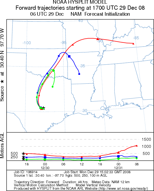
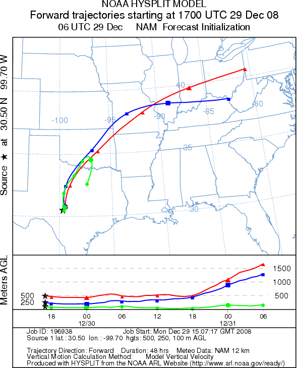
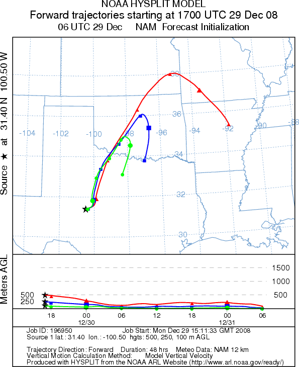
Trajectory Start (s) (shown by *
on map): Austin, TX; Junction, TX; San Angelo, TX.
AUSTIN
JUNCTION
SAN ANGELO
EDWARDS PLATEAU COMPOSITE
Prepared by: Estelle
Levetin (Faculty of Biological
Science, The University
of Tulsa, 800 S. Tucker Dr., Tulsa, OK 74104) and ) and Peter K Van de Water (Department
of Earth and Environmental Science, California State University Fresno, 2576 East San Ramon Avenue, M/S ST24, Fresno
CA 93740-8039). This forecast gives the anticipated future track of released Mountain Cedar pollen, weather conditions
over the region and along the forecast pathway, and an estimated time of arrival for various metropolitan areas.
Questions: Aerobiology Lab e-mail: pollen@utulsa.edu
Return to Forecasting Home Page