
The University of Tulsa
Mountain Cedar Pollen Forecast
Metropolitan Area |
Exposure Risk |
|
Dallas/Fort Worth |
Low |
|
Austin |
Moderate |
|
San Antonio |
Moderate |
Date Issued: 17
December 2009
Mountain Cedar location(s):
Edwards Plateau, Texas
Regional weather:
Thursday, December 17 TX/OK: Across the region the weather will be warming today with temperatures expected in
the upper 50s. north and lower 60s south Temperatures in Oklahoma will be in the upper 50s in central Oklahoma
and in the Arbuckle Mountain area. Skies will be partly cloudy throughout the forecast period. Winds will be
moderate today from the south switching late in the afternoon and overnight, coming from the north tomorrow and
tomorrow night. Temperatures in Texas today will be in the mid 50s from the border area with Oklahoma, south along
the eastern portion of the Edwards Plateau. Across the Plateau temperatures will warm into the lower to mid 60s..
There is a chance of rain, 20%-30%, along the Edwards Plateau edge communities this morning into the early afternoon.
Moisture is moving north from the Gulf of Mexico into the area stretching as far north as Waco. Winds will begin
today from the south at low to moderate levels across the region. Wind strength will decline overnight and switch
from the south to the west and eventually from the north beginning tomorrow during the day and tomorrow night.
Skies today will be in the east mostly cloudy to the west becoming partly cloudy to sunny west and south.. Sunny
skies are expected to prevail across the region tomorrow with clouds building overnight Friday.
Trajectory weather:
Mostly to partly cloudy skies will occur across the eastern portion of central Texas with the chance of rain this
morning around the edge of the Edwards Plateau. Showers are expected in San Antonio and Austin as moisture moves
up off the Gulf of Mexico. Rain is expected as far north as Waco, funneling moisture as far north as Waco Temperatures
will warm into the 50s today along the eastern areas of the Edwards Plateau and into the 60s to the west. Winds
will be from the northeast around the edges of the Plateau but from the south elsewhere. Winds will be moderate
today declining to light conditions tonight as the rotate from the west, eventually coming out of the north tomorrow
and tomorrow night. Skies tomorrow will be sunny to mostly sunny with temperatures reaching into the 60s. Friday
night skies will return to partly cloudy conditions with winds from the north and temperatures in the mid to lower
30s west and lower 40s in the edge communities of the Edwards Plateau. The air is mostly stable to heavy and will
decrease in elevation over time moving across the ground, conditions that do not entrain nor move significant amounts
of pollen over long distances. Today, conditions will be moderate as temperatures warm and cloudy skies predominate.
Conditions will improve tomorrow with clearing skies and warmer conditions. Significant threats will occur across
the region with trees tomorrow, with good conditions for release but marginal for travel outside the immediate
area.
OUTLOOK:
*** Moderate Threat today; Moderate threat
tomorrow *** Moderateconditions
for pollen release today and Moderate conditions tomorrow;poor conditions for entrainment and transport today,
Moderate conditions tomorrow. Cool air temperatures with
high humidity and rain this morning that should clear the air will occur in the edge communities today. Further
towards the west the air will be dryer and conditions improve for pollen release as temperatures should make it
into the 60s. Winds will be moderate from the south but declining during the afternoon and evening becoming light
and variable overnight. The moister along the eastern edge of the Edwards Plateau is expected to dissipate overnight
leaving the region sunny tomorrow with warming temperatures and light to moderate winds from the north. The greatest
chance for pollen release will occur in the western areas of Juniperus asheis distribution. To the east high
humidity and morning rain will cleanse the skies and add moisture to the trees. Clearing skies with warm temperatures
tomorrow will result in a moderate threat tomorrow. the air will remain heavy, and wet to the east today but
much drier towards the west. Light winds across the region will result in the trajectories swirling over central
Texas and no long distance export of pollen is expected. Reports indicate that the trees are ready to pollinate.
Conditions will build over the next two days, but conditions for pollen to spread form the local areas where the
trees grow will be marginal. The chance of heightened levels tomorrow is more likely. Local dispersal should
occur leading to spotty high concentrations.
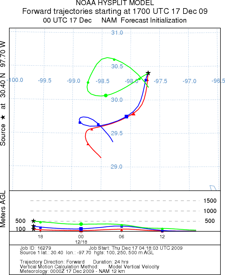
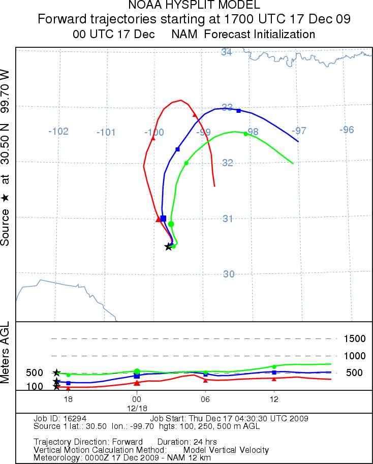
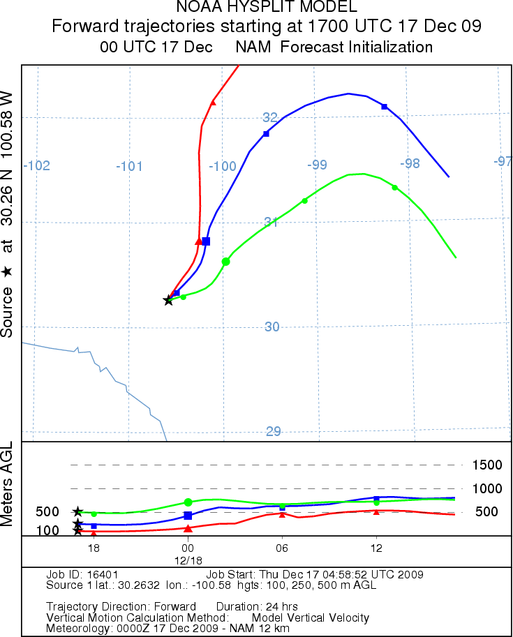
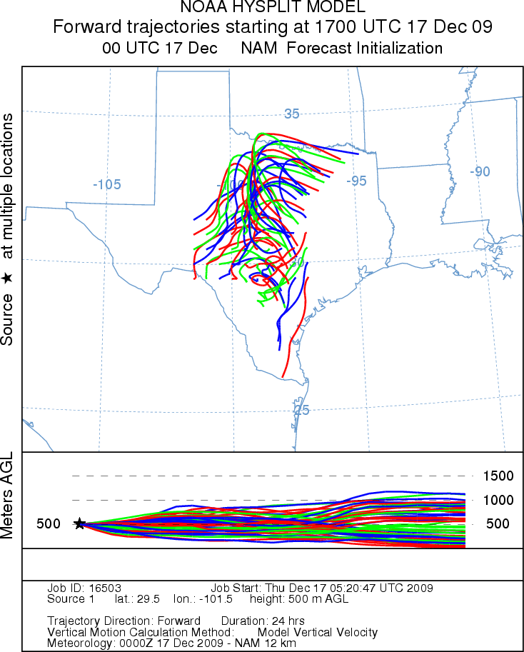
Trajectory Start (s) (shown by *
on map): Austin, TX; Junction, TX; Sonora, TX.
AUSTIN
JUNCTION
SONORA
EDWARDS PLATEAU COMPOSITE
Prepared by: Estelle
Levetin (Faculty of Biological
Science, The
University of Tulsa, 800 S. Tucker Dr., Tulsa, OK 74104) and ) and Peter
K Van de Water (Department of Earth and Environmental Science, California State University Fresno,
2576 East San Ramon Avenue, M/S ST24, Fresno CA 93740-8039). This forecast gives the anticipated future track of
released Mountain Cedar pollen, weather conditions over the region and along the forecast pathway, and an estimated
time of arrival for various metropolitan areas.
Questions: Aerobiology Lab e-mail: pollen@utulsa.edu
Return to Forecasting Home Page