The University of Tulsa
Mountain Cedar Pollen Forecast

Metropolitan Area |
Exposure Risk |
|
Oklahoma City |
High |
|
Tulsa |
Moderate |
|
St. Louis MO |
Low |
Date Issued: 22 December 2009
Mountain Cedar Location(s): Arbuckle Mountains, OK
Regional Weather: Tuesday, December 22 TX/OK:
Across the region the weather will begin to deteriorate as colder conditions and precipitation moves into the area.
Ahead of this weather change temperatures will be warm today, tonight and tomorrow, then start cooling off late
tomorrow into tomorrow night. In Oklahoma temperatures will be in the the upper 50s in the center of the state
and in the low 60s along the border with Texas. Skies, however will be cloudy for the entire forecast period.
Along the Oklahoma/Texas border area morning drizzle and a chance of fog occurs today and tomorrow. Winds will
be moderate from the south to southeast today and tomorrow. Tomorrow night as colder air moves southward from
the north, winds will switch coming from the northwest to westerly direction. In southern Oklahoma and northern
Texas there is an increasing chance of precipitation starting tonight (50%), into tomorrow (70%) and tomorrow night
(80%). Temperatures in Texas today and tomorrow will be warm, in the upper 60s and lower 70s. Skies will be mostly
cloudy to cloudy today, tonight, tomorrow and tomorrow night. In the areas east of the Edwards Plateau and along
its edge, The chance of precipitation starts tonight and increases tomorrow, 30% chance in Austin. Tomorrow night
the entire central Texas area has an increased chance of precipitation ranging from 50% chance in the surrounding
edge communities and 30-50% on the Plateau. Winds will be from the south at moderate speeds (5 to 10 miles per
hour) today and tonight. Tomorrow, winds will increase as the colder air begins to approach the area. Tomorrow
night winds will reverse coming from the north rather than the current southerly direction. Winds will be strong,
especially across the Edwards Plateau tomorrow night.
Trajectory weather: Cloudy skies will occur across the region today, with temperatures in the upper 50s
in central Oklahoma and into the lower 60s to the south along the border with Texas. The area will have relatively
high humidity this morning with the chance of drizzle and fog. Winds will be moderate from the south gaining in
strength in the afternoon. Tonight skies will remain cloudy with winds dying in strength, but with warm temperatures
in the mid to upper 40s and low 50s. There is a significant chance of thundershowers overnight throughout the
area. Tomorrow will see a warming into the 60s and 70s. Winds will continue from the south to southeast with
moderate wind speeds towards the north but much stronger conditions southward. A significant chance of rain will
continue throughout the region into the evening when the chance of precipitation will be near 80%. As the colder
air arrives tomorrow nights low temperatures will fall into the 30s and low 40s. Winds will shift from the current
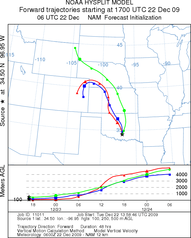
southerly direction coming from the north and northwest. Today the trajectories northward across central Oklahoma
towards the western central Great Plains, towards the low pressure moving out of the Northern Rocky Mountains..
The movement of air northward from the Gulf of Mexico will bring significant amounts of humidity with it, resulting
in the chance of Thunderstorms this afternoon and into the evening spreading northward. The air appears relatively
heavy traveling along the ground which is usually poor conditions for entrainment and travel over long distances..
OUTLOOK: *** Moderate Threat today; Low threat tomorrow
*** Moderate conditions for pollen release today;Moderate conditions for entrainment and transport today. Warm
conditions with increasing wind speeds but cloudy skies and increasing humidity will occur near the Arbuckle Mountain
population today. A significant chance of precipitation will begin to build this afternoon resulting in precipitation
tonight, tomorrow and tomorrow night. Tomorrow conditions will continue to degrade as a cold front pushes southward
out of the northern Rocky Mountains. Today, warm air and increasing wind speeds will occur across the area, but
with cloudy to mostly cloudy skies and increasing humidity. The conditions for pollen release in the Arbuckle
Mountain population are reduced but some limited release may occur. Therefore the forecast calls for a moderate
threat today. However with an increasing chance of precipitation tonight and tomorrow poor conditions is forecast
for tomorrow. Moderate winds but with heavy humid air that is stable to sinking at the surface results in moderate
to poor conditions today, then increasing humidity makes for poor entrainment and travel tomorrow. Winds will
remain from the south moving any entrained pollen northward across Oklahoma and into the central Great Plains.
Trajectory Start (s) (shown by black
star on map): Davis, OK.
Prepared by: Estelle
Levetin
(Faculty
of Biological Science, The University of Tulsa, 800 S. Tucker Dr., Tulsa, OK 74104) and Peter
K Van de Water
(Department of Earth and Environmental Science, California State University Fresno, 2576 East San Ramon Avenue,
M/S ST24, Fresno CA 93740-8039). This forecast gives the anticipated future track of released Mountain Cedar pollen,
weather conditions over the region and along the forecast pathway, and an estimated time of arrival for various
metropolitan areas.
Questions: Aerobiology Lab e-mail: pollen@utulsa.edu
Return to Forecasting Home Page