
The University of Tulsa
Mountain Cedar Pollen Forecast
Metropolitan Area |
Exposure Risk |
|
Dallas/Fort Worth |
Moderate |
|
Austin |
Moderate |
|
San Antonio |
Moderate |
Date Issued: 22 December 2009
Mountain Cedar Location(s): Edwards Plateau, Texas
Regional Weather:
Tuesday, December 22 TX/OK: Across
the region the weather will begin to deteriorate as colder conditions and precipitation moves into the area. Ahead
of this weather change temperatures will be warm today, tonight and tomorrow, then start cooling off late tomorrow
into tomorrow night. In Oklahoma temperatures will be in the the upper 50s in the center of the state and in the
low 60s along the border with Texas. Skies, however will be cloudy for the entire forecast period. Along the
Oklahoma/Texas border area morning drizzle and a chance of fog occurs today and tomorrow. Winds will be moderate
from the south to southeast today and tomorrow. Tomorrow night as colder air moves southward from the north,
winds will switch coming from the northwest to westerly direction. In southern Oklahoma and northern Texas there
is an increasing chance of precipitation starting tonight (50%), into tomorrow (70%) and tomorrow night (80%).
Temperatures in Texas today and tomorrow will be warm, in the upper 60s and lower 70s. Skies will be mostly cloudy
to cloudy today, tonight, tomorrow and tomorrow night. In the areas east of the Edwards Plateau and along its
edge, The chance of precipitation starts tonight and increases tomorrow, 30% chance in Austin. Tomorrow night
the entire central Texas area has an increased chance of precipitation ranging from 50% chance in the surrounding
edge communities and 30-50% on the Plateau. Winds will be from the south at moderate speeds (5 to 10 miles per
hour) today and tonight. Tomorrow, winds will increase as the colder air begins to approach the area. Tomorrow
night winds will reverse coming from the north rather than the current southerly direction. Winds will be strong,
especially across the Edwards Plateau tomorrow night.
Trajectory weather: Mostly cloudy to cloudy skies will occur
region wide with the chance of morning drizzle and fog around the edge of the Edwards Plateau. The Plateau region
will have mostly cloudy conditions with less chance of significant morning moisture. Temperatures will reach into
the upper 60s to low 70s today and tomorrow. Winds will be steady at moderate wind speeds of 10 to 15 miles per
hour from the south. To the north winds will build to strong conditions during the afternoon. The southerly winds
will bring heightened levels of humidity in the atmosphere. Tonight the northern communities will see an increase
in the chance of precipitation. Winds will remain unseasonably warm in the 50s and 60s overnight. Tomorrow will
have cloudy to mostly cloudy skies. Partly cloudy skies will occur over the southwestern portion of the Plateau.
Across the eastern portion of the region increasing levels of humidity and a cold front moving in from the northwest
will lead to increasing chances of precipitation. Precipitation will begin in the north, move along the eastern
edge of the Edwards Plateau and by tomorrow evening be relatively region wide. Tomorrow night temperatures will
be in the upper 30s to low 40s with the wind shifting, coming out of the north to northwest.
OUTLOOK: *** Moderate Threat today; Low
threat tomorrow *** Moderate conditions for pollen release today; poor conditions for entrainment
and transport today. Warm conditions and moderate to strong
winds, but with increasing humidity and cloudy skies will occur today across the region. Trajectories show that
the surface winds will be heavy and move along the ground, conditions not particularly good for long distance travel.
The upper winds are more buoyant, thus if pollen get up into the atmosphere it may travel some distance. Because
of these mixed conditions a moderate threat and conditions for release are called for. The heavy air and increasing
humidity should limit the amount of entrainment and travel thus poor conditions are listed. These conditions will
be deteriorating towards tomorrow and the cold front pushes closer. There is an increasing chance of precipitation
tomorrow during the day then into tomorrows evening hours. The deteriorating conditions result in a low threat
and poor conditions for release along with entrainment and transport tomorrow.
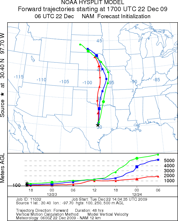
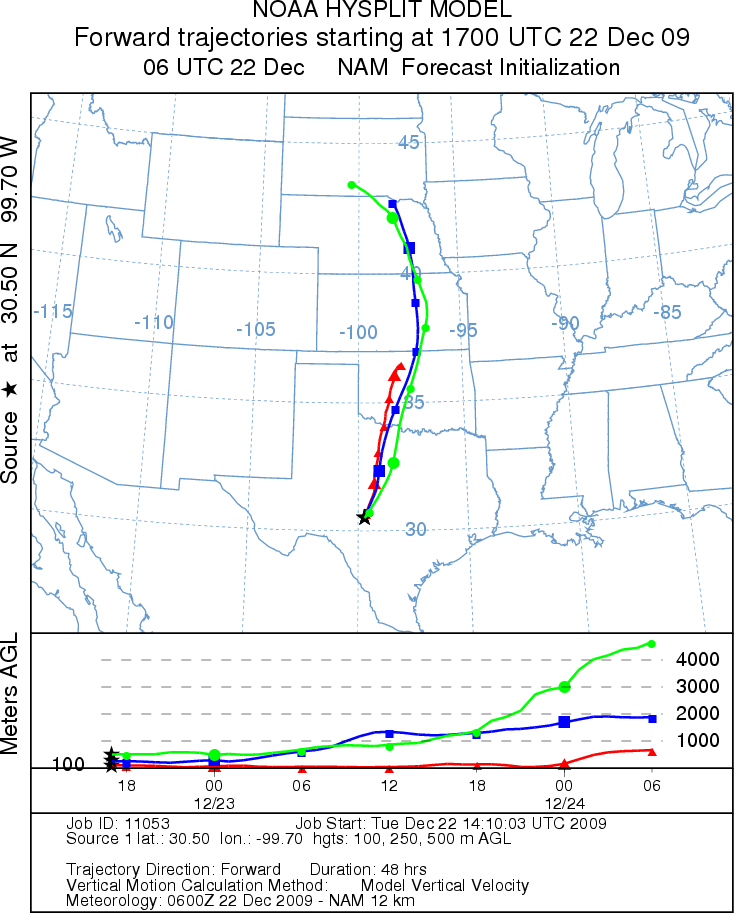
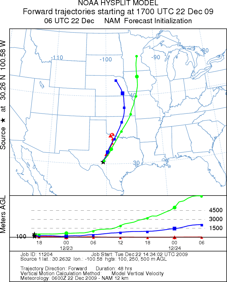
Trajectory Start (s) (shown by *
on map): Austin, TX; Junction, TX; Sonora, TX.
AUSTIN
JUNCTION
SONORA
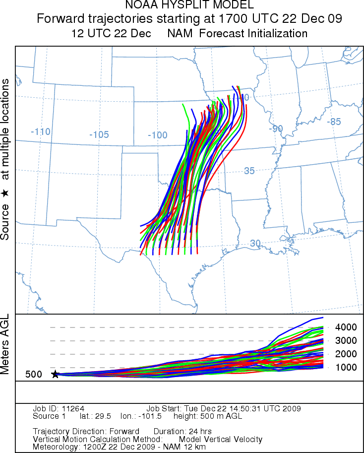
EDWARDS PLATEAU COMPOSITE
Prepared by: Estelle
Levetin (Faculty of Biological
Science, The
University of Tulsa, 800 S. Tucker Dr., Tulsa, OK 74104) and ) and Peter
K Van de Water (Department of Earth and Environmental Science, California State University Fresno,
2576 East San Ramon Avenue, M/S ST24, Fresno CA 93740-8039). This forecast gives the anticipated future track of
released Mountain Cedar pollen, weather conditions over the region and along the forecast pathway, and an estimated
time of arrival for various metropolitan areas.
Questions: Aerobiology Lab e-mail: pollen@utulsa.edu
Return to Forecasting Home Page