The University of Tulsa
Mountain Cedar Pollen Forecast

Metropolitan Area |
Exposure Risk |
|
Oklahoma City |
Moderate |
|
Tulsa |
Moderate |
|
St. Louis MO |
Low |
Date Issued: 23 December 2009
Mountain Cedar Location(s): Arbuckle Mountains, OK
Regional Weather: Wednesday, December 23 TX/OK:
Across the region the weather will be warm today with temperatures expected into the 60s to the north and from
the upper 60s into the 70s towards the south. Cloudy to mostly cloudy skies will be the norm across the region
and a significant chance of afternoon showers and thunderstorms occurs region wide. On the Edwards Plateau the
chance of precipitation is less especially towards the southwestern areas. Conditions will continue to deteriorate
as a significant winter storm moves out of the west into the central and northern Great Plains where it is expected
to intensify. Temperatures will be in the upper 60s in central Oklahoma and in the Arbuckle Mountain area today.
Skies will be cloudy to mostly cloudy today and tonight then some partial clearing is on tap for Thursday and
Thursday evening. There is a significant chance of precipitation today, it increases tonight and still lingers
into Thursday. By Thursday night skies should begin to clear. Temperatures tonight will drop into the 30s, with
tomorrows expected high in the upper 30s to low 40s and then Thursday night diving into the mid to low 20s.
Winds will be moderate from the southwest during the day today then switch from the northwest as the cold front
associated with the weather system to the north moves through. Light and variable to moderate conditions will
occur tonight with strong winds, 20 to 30 miles an hour, returning tomorrow night. Temperatures in Texas today
will also be warm with highs expected in the upper 60s to lower 70s range. However skies will be cloudy to the
north, thinning to partly cloudy conditions towards the southwest. The entire Texas region has a chance of rain
today, with a greater threat towards the north. Winds will begin from the south to southwest, but as the front
starts to pass to the north will switch, coming from the west. Overnight the chance of showers and rain increases
across the region. Temperatures will be in the upper 30s to lower 40s and winds will become moderate to strong
starting from the west but eventually shifting to a northwesterly direction. On Thursday skies should begin to
clear but with very strong winds across the Edwards Plateau and in the surrounding communities. Temperatures will
rebound into the upper 50s and lower 60s in the edge communities but stay in the 40s across the Edwards Plateau.
Thursday night will be mostly clear with cold air settling in. Temperatures will be in the 20s on the Plateau
and lower 30s at lower elevations surrounding the plateau.
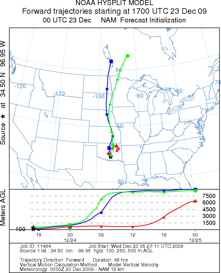
Trajectory weather: Mostly cloudy skies will occur across the region today and tomorrow, with temperatures
in the upper 60s in central Oklahoma and along the southern border with Texas. Humidity is expected to be high
and there is a 50% chance of showers. Winds will be moderate from the south today. Tonight skies will remain
cloudy with light to moderate winds and temperatures in the mid to lower 30s. Wind direction will shift overnight
from the south to the northwest. The 50% chance of rain continues Tomorrow will experience much colder weather
with temperatures reaching into the upper 30s and lower 40s. Winds will continue from the northwest but be strong
towards the north, 20 to 30 miles per hour, and weaken to moderately strong conditions towards the south. Thursday
night will be partly cloudy and cold with temperatures in the low to mid 20s. Today and tomorrow, the trajectories
move northward across central Oklahoma and Oklahoma City then onward to Kansas and to northern and western most
Missouri. The air appears relatively stable traveling at about the same elevation. These conditions can be marginal
for entrainment; however, with moderate winds some pollen may make it into the air stream. However with the chance
of precipitation across the area, this pollen potentially will simply get washed out. In addition the higher humidity
and chance of precipitation should retard pollen dispersal from the trees.
OUTLOOK: *** Moderate Threat today; low threat tomorrow
*** Moderate conditions for pollen release today and poor conditions tomorrow; Poor conditions for entrainment
and transport today and tomorrow. Warm conditions but with cloudy skies and a chance of rain across the region
will most likely retard pollen from being shed. Any pollen grains that are released should find it difficult to
get entrained within the atmosphere and moved any distance because of the weather conditions. Tomorrow weather
conditions will deteriorate further as cold air continues to move into the area with a slight reduction in the
chance of rain but humid cloudy conditions. For these reasons a low threat exists today and tomorrow with poor
conditions for release, entrainment and travel.
Trajectory Start (s) (shown by black
star on map): Davis, OK.
Prepared by: Estelle
Levetin
(Faculty
of Biological Science, The University of Tulsa, 800 S. Tucker Dr., Tulsa, OK 74104) and Peter
K Van de Water
(Department of Earth and Environmental Science, California State University Fresno, 2576 East San Ramon Avenue,
M/S ST24, Fresno CA 93740-8039). This forecast gives the anticipated future track of released Mountain Cedar pollen,
weather conditions over the region and along the forecast pathway, and an estimated time of arrival for various
metropolitan areas.
Questions: Aerobiology Lab e-mail: pollen@utulsa.edu
Return to Forecasting Home Page