
The University of Tulsa
Mountain Cedar Pollen Forecast
Metropolitan Area |
Exposure Risk |
|
Dallas/Fort Worth |
Moderate |
|
Austin |
Moderate to High |
|
San Antonio |
Moderate |
Date Issued: 23 December 2009
Mountain Cedar Location(s): Edwards Plateau, Texas
Regional Weather: Wednesday,
December 23 TX/OK: Across
the region the weather will be warm today with temperatures expected into the 60s to the north and from the upper
60s into the 70s towards the south. Cloudy to mostly cloudy skies will be the norm across the region and a significant
chance of afternoon showers and thunderstorms occurs region wide. On the Edwards Plateau the chance of precipitation
is less especially towards the southwestern areas. Conditions will continue to deteriorate as a significant winter
storm moves out of the west into the central and northern Great Plains where it is expected to intensify. Temperatures
will be in the upper 60s in central Oklahoma and in the Arbuckle Mountain area today. Skies will be cloudy to
mostly cloudy today and tonight then some partial clearing is on tap for Thursday and Thursday evening. There
is a significant chance of precipitation today, it increases tonight and still lingers into Thursday. By Thursday
night skies should begin to clear. Temperatures tonight will drop into the 30s, with tomorrows expected high
in the upper 30s to low 40s and then Thursday night diving into the mid to low 20s. Winds will be moderate from
the southwest during the day today then switch from the northwest as the cold front associated with the weather
system to the north moves through. Light and variable to moderate conditions will occur tonight with strong winds,
20 to 30 miles an hour, returning tomorrow night. Temperatures in Texas today will also be warm with highs expected
in the upper 60s to lower 70s range. However skies will be cloudy to the north, thinning to partly cloudy conditions
towards the southwest. The entire Texas region has a chance of rain today, with a greater threat towards the north.
Winds will begin from the south to southwest, but as the front starts to pass to the north will switch, coming
from the west. Overnight the chance of showers and rain increases across the region. Temperatures will be in
the upper 30s to lower 40s and winds will become moderate to strong starting from the west but eventually shifting
to a northwesterly direction. On Thursday skies should begin to clear but with very strong winds across the Edwards
Plateau and in the surrounding communities. Temperatures will rebound into the upper 50s and lower 60s in the
edge communities but stay in the 40s across the Edwards Plateau. Thursday night will be mostly clear with cold
air settling in. Temperatures will be in the 20s on the Plateau and lower 30s at lower elevations surrounding
the plateau.
Trajectory weather: Cloudy skies will occur across Texas
with fog and drizzle this morning and a chance of rain today that ranges from 60% northward to 20% across the southwestern
and western areas of the Edwards Plateau. Temperatures will be warm, ranging from the mid 70s along the southern
edge of the Edwards Plateau, to upper 60s on the Plateau itself. Winds will be moderate from the southwest.
Tonight the chance of rain increases as the cold from moves into the region. Winds will start to move coming from
the west but maintaining moderate conditions but strengthening towards the west. Lows tonight will be in the upper
30s to mid 40s. On Thursday, the fast moving low pressure system to the north will have less of an influence on
Texas weather, however cold air will have settled in. Skies will return to partly sunny to sunny conditions.
High temperatures for Thursday will be in the upper 40s for most regions. The areas along the southern and southeastern
edge of the Edwards Plateau will warm into the upper 50s and low 60s. Winds, however will be moderate to strong,
15 to 25 miles per hour during the day. Thursday night will be cold with conditions close to freezing and below.
ahead of the cold front moving southeastward across the region. Today ground level trajectories travel slightly
northward before the northwest winds move into the area turning them towards the southeast. At upper levels of
the atmosphere, the trajectories get caught in regional air movement towards the low pressure moving across the
central plains over the next 48 hours. With warm conditions pollen may be released but with the heavy humid air
it is not expected to be significantly entrained into the atmosphere. Any pollen that is entrained will move in
heavy, humid atmosphere near the ground and could be rained out with the chance of showers and precipitation that
occurs across the region. Any significant movement northward will eventually become influenced by the precipitation
to the north in central Oklahoma and beyond. Today, conditions will be moderate as temperatures warm but tempered
by cloudy skies, high humidity and the chance of rain throughout the area. Conditions will deteriorate through
the night with increasing chances of precipitation and colder temperatures. tomorrow conditions will start clearing
but colder conditions will prevail into the evening hours when below freezing conditions are expected for most
areas.
OUTLOOK: *** Moderate Threat today; Low
threat tomorrow *** Moderate conditions for pollen release
today and poor conditions tomorrow; Poor conditions for entrainment and transport today and tomorrow. Warm conditions but with cloudy skies and high humidity will occur with an
increasing chance of precipitation today and tonight. Winds will be moderate from the south to southwest switching
to a more westerly direction overnight. Temperatures will be in the upper 60s to low 70s region-wide today. As
the cold front moves across the region tomorrow temperatures will only warm into the 40s. On Thursday skies will
begin to clear with mostly clear skies overnight. The region wide chance of precipitation along with cloudy skies
and humid conditions results in only a moderate threat today and coupled with coming cold temperatures a low threat
tomorrow. Heavy air at the surface with high humidity results in poor conditions for entrainment. Long distance
transport is not expected to occur because of poor conditions at the surface. However, there is a chance of heightened
levels from local dispersal events.
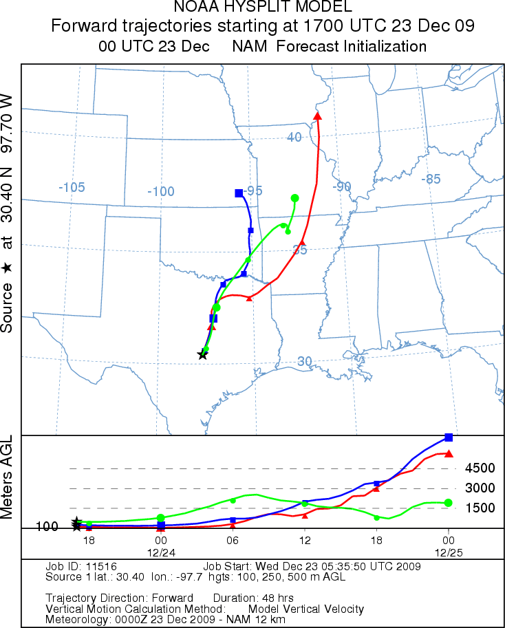
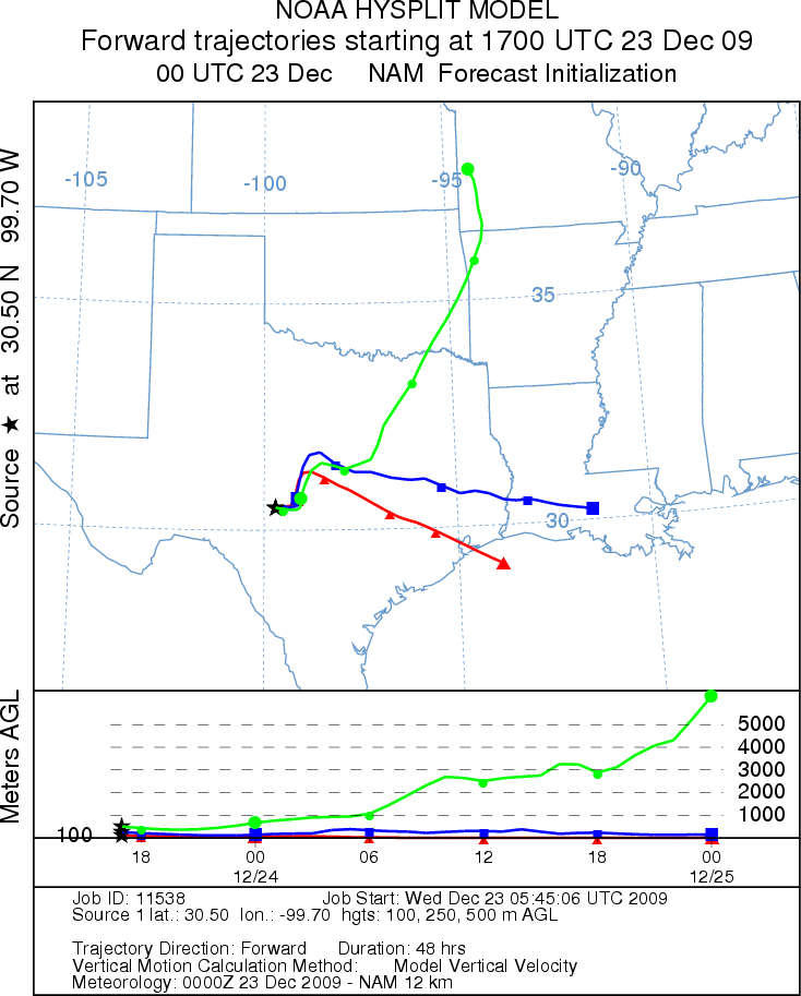
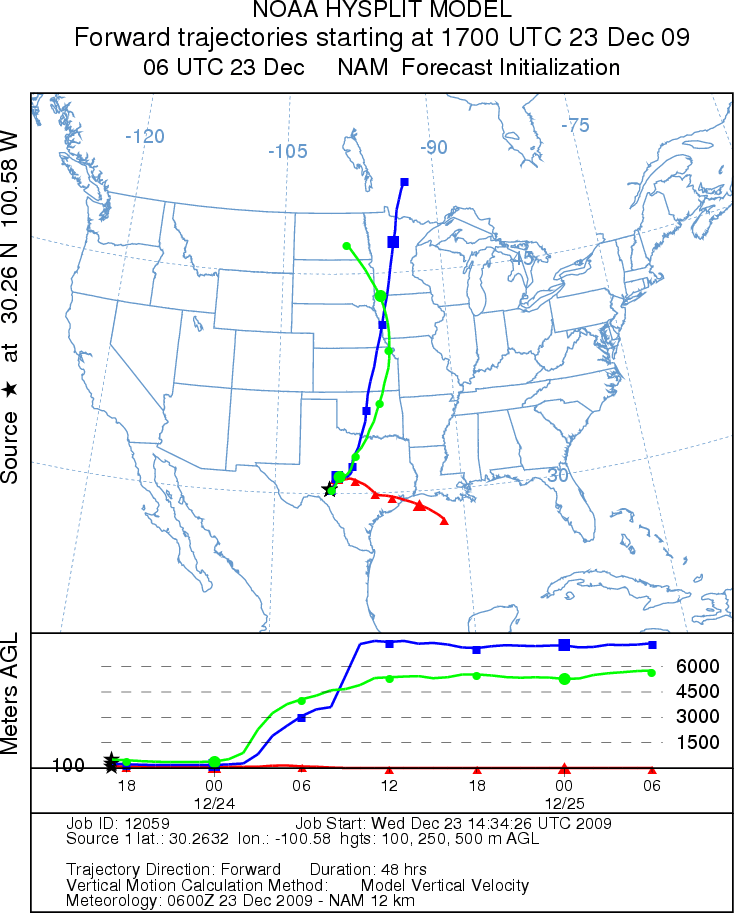
Trajectory Start (s) (shown by *
on map): Austin, TX; Junction, TX; Sonora, TX.
AUSTIN
JUNCTION
SONORA
EDWARDS PLATEAU COMPOSITE
Prepared by: Estelle
Levetin (Faculty of Biological
Science, The
University of Tulsa, 800 S. Tucker Dr., Tulsa, OK 74104) and ) and Peter
K Van de Water (Department of Earth and Environmental Science, California State University Fresno,
2576 East San Ramon Avenue, M/S ST24, Fresno CA 93740-8039). This forecast gives the anticipated future track of
released Mountain Cedar pollen, weather conditions over the region and along the forecast pathway, and an estimated
time of arrival for various metropolitan areas.
Questions: Aerobiology Lab e-mail: pollen@utulsa.edu
Return to Forecasting Home Page