
The University of Tulsa
Mountain Cedar Pollen Forecast
Metropolitan Area |
Exposure Risk |
|
Dallas/Fort Worth |
Low |
|
Austin |
Moderate |
|
San Antonio |
Moderate |
Date Issued: 28 December 2009
Mountain Cedar Location(s): Edwards Plateau, Texas
Regional Weather: Monday,
December 28 TX/OK:
Across the region the weather will be cool today degrading overnight with regional precipitation over Oklahoma
and Texas, tomorrow. Winds over Texas will be moderate from the northeast but the trajectories show a general
rotation into west Texas and eastern New Mexico over the next 24 hours. In Oklahoma winds will remain light and
variable today and tonight picking up tomorrow from the southeast at moderate levels. Temperatures will remain
cold with highs from the upper 30s to lower 40s from central Oklahoma southward. An increasing chance of precipitation
will begin overnight with a 30 to 50% chance of snow falling on Tuesday and Tuesday night. Winds on Tuesday will
remain light and variable in southern Oklahoma but reach moderate levels to the north in central Oklahoma. In
Texas, cool conditions will occur across the central area today with highs reaching into the upper 40s and low
50s on the Edwards Plateau and the mid to upper 50s in the edge communities of Austin and San Antonio. Tonight
an increasing chance of precipitation will move into the area starting as rain and sleet followed by show on Tuesday
and returning to rain on Tuesday night. Temperatures will remain in the 30s for most of the region both tonight,
tomorrow, and tomorrow night. Winds will begin today from the northeast at moderate levels and maintain their
strength overnight. Tomorrow the winds will remain moderate but begin to shift, coming from the southwest on the
Edwards Plateau Tuesday night. The chance of precipitation will continue region wide through Tuesday night.
Trajectory weather:
Mostly sunny skies will occur in the communities surrounding the Edwards Plateau this morning with moderate winds
from the north and northeast. On the Plateau partly cloudy skies are expected also with moderate northeast winds.
Temperatures will be in the mid to upper 50s in the edge communities and just reaching 50 degrees on the Plateau.
Pollen dispersal may occur this morning but the entrainment and movement of that pollen will become mixed into
the degrading weather. These conditions will begin to degrade towards the afternoon as clouds begin to build in
the sky to cloudy conditions and an increasing chance of precipitation region wide. Overnight temperatures will
be in the lower 30s with a significant chance of precipitation first falling as rain and sleet then shifting towards
snow. Winds will remain moderate from the northeast overnight and tomorrow. The threat of precipitation remains
high all day tomorrow with temperatures in the mid 30s on the Plateau and upper 40s in the edge communities. Tomorrow
night the chance of precipitation begins to decrease as winds begin to shift to a more southerly direction. Lows
tomorrow will remain in the 30s.
OUTLOOK: *** Moderate Threat today; Low tomorrow *** Moderate conditions
for pollen release today and Poor conditions tomorrow; Moderate conditions for entrainment and transport today,
Poor conditions tomorrow. Cool conditions today with moderate
winds and partly cloudy skies early will occur across the area. Conditions are marginal for pollen release although
the edge communities may see release and experience moderate to high concentrations. For this reason, a moderate
threat exists for pollen. This afternoon, however, conditions will begin to degrade with increasing clouds, falling
temperatures and an increased chance of precipitation. Overnight temperatures will drop into the 30s and precipitation
will fall first as rain and sleet then snow. These wet conditions will last tonight, tomorrow and tomorrow night.
These conditions will result in poor conditions for entrainment and travel later today through tomorrow. The
buoyancy shown in the trajectories will occur late in their travel path after they have moved over any potentially
pollinating populations.
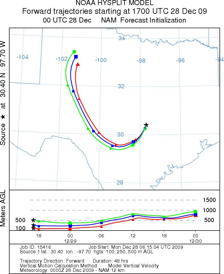
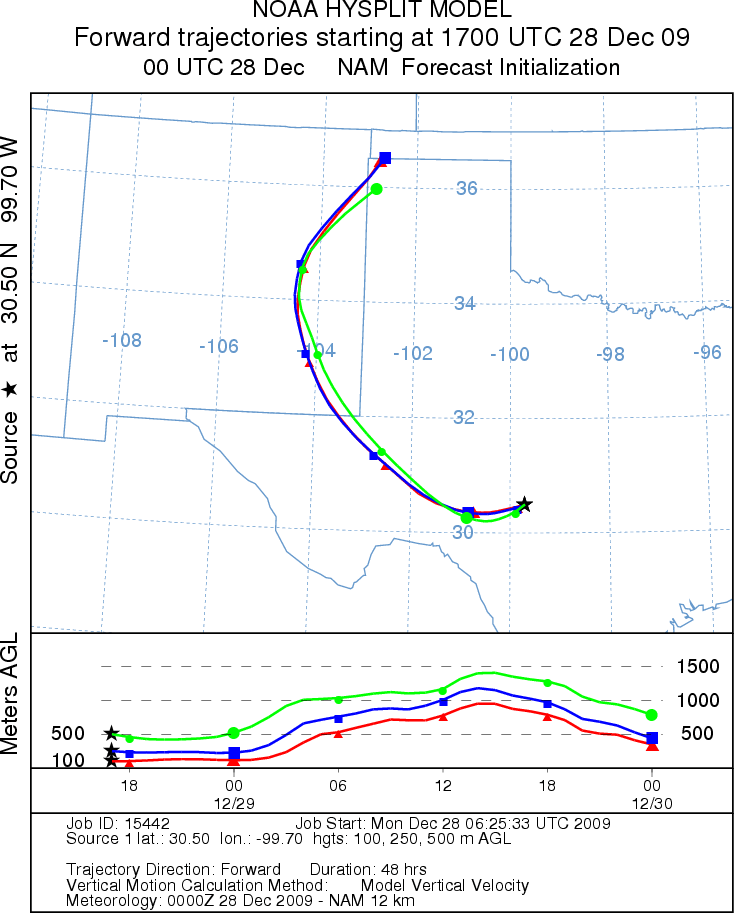
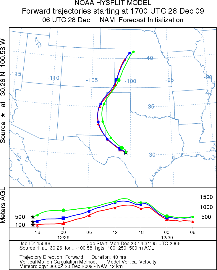
Trajectory Start (s) (shown by *
on map): Austin, TX; Junction, TX; Sonora, TX.
AUSTIN
JUNCTION
SONORA
EDWARDS PLATEAU COMPOSITE
Prepared by: Estelle
Levetin (Faculty of Biological
Science, The
University of Tulsa, 800 S. Tucker Dr., Tulsa, OK 74104) and ) and Peter
K Van de Water (Department of Earth and Environmental Science, California State University Fresno,
2576 East San Ramon Avenue, M/S ST24, Fresno CA 93740-8039). This forecast gives the anticipated future track of
released Mountain Cedar pollen, weather conditions over the region and along the forecast pathway, and an estimated
time of arrival for various metropolitan areas.
Questions: Aerobiology Lab e-mail: pollen@utulsa.edu
Return to Forecasting Home Page