
The University of Tulsa
Mountain Cedar Pollen Forecast
Metropolitan Area |
Exposure Risk |
|
Dallas/Fort Worth |
Low |
|
Austin |
Low |
|
San Antonio |
Low |
Date Issued: 29 December 2009
Mountain Cedar Location(s): Edwards Plateau, Texas
Regional Weather: Tuesday,
December 29 TX/OK: Across
the region the weather will be cold today with a significant chance of precipitation both north and south. To
the north in Oklahoma snow is expected in central and southern Oklahoma, while in northern and central Texas rain
will change to sleet and snow during today and into tonight. Accumulations of up to a couple inches are expected
in areas on the Edwards Plateau. Winds in Oklahoma will be light and variable building towards light to moderate
conditions in northern Texas from the northeast. Overnight winds will remain light. Over the Edwards Plateau
winds will be moderate from the southeast shifting from the west and southwest tonight. The Edwards Plateau has
a 90% chance of precipitation today, then dropping during the evening horus and overnight. The chance of precipitation
in the edge communities surrounding the Plateau will remain high overnight with declining chances at sites in northern
Texas into central Oklahoma. Temperatures across the region today and tonight will remain in the 30s. Tomorrow
cloudy and mostly cloudy skies will remain but temperatures will begin to climb out of the 30s reaching the 40s
across Oklahoma and into the low 50s across most of Texas. The southern edge communities will reach for the 60s
during the day. Winds will be light to moderate from the southwest and west. A chance of precipitation will remain
in the edge communities as well as to the north in central Oklahoma. Wednesday night skies will begin to break-up
with partly cloudy skies in most areas and temperatures in the 20s to the north and 30s across Texas.
Trajectory weather: Cloudy, cold and wet are the conditions
that will dominate today and tonight. Cold air is across the region with the chance of rain turning to sleet and
snow for most of Texas. The exception is the edge communities which will remain slightly warmer and thus rain
is expected. Conditions will remain in the 30s overnight with a significant chances for precipitation remaining
in all areas except for the western most locations. Winds will be light to moderate from the northeast in northern
Texas and the edge communities of Austin and San Antonio. On the Edwards Plateau winds will be from the southeast.
Tonight winds will remain light but will switch from the northeast to the north and from the southeast to the
southwest. Pollen dispersal should not occur today and tonight with the cold, wet conditions. Any particles will
have trouble getting entrained and their movement will limited because of precipitation. Overnight temperatures
will be in the lower 30s with a significant chance of precipitation in the edge communities and very humid conditions.
OUTLOOK: *** Low Threat today; Low tomorrow
*** Poor conditions for pollen release today and Poor
conditions tomorrow; Poor conditions for entrainment and transport today, Poor conditions tomorrow. Cold conditions and precipitation today with moderate winds and cloudy skies
occur across the region result in very poor conditions for any pollen release today and tonight. Overnight temperatures
will drop into the 30s and precipitation will continue as the system moves through the region. Wet conditions
will continue tonight, tomorrow and tomorrow night the chance of precipitation diminishes. Tomorrows temperatures
will begin to build again as the skies are expected to begin to break-up in the afternoon and evening. Tomorrows
temperatures will be in the low 50s to low 60s along the edge of the Edwards Plateau.. These conditions will result
in poor conditions for entrainment and travel during the forecast period
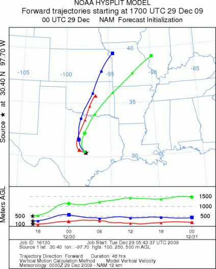
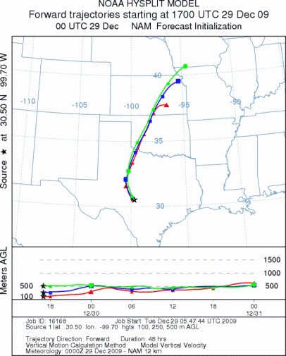
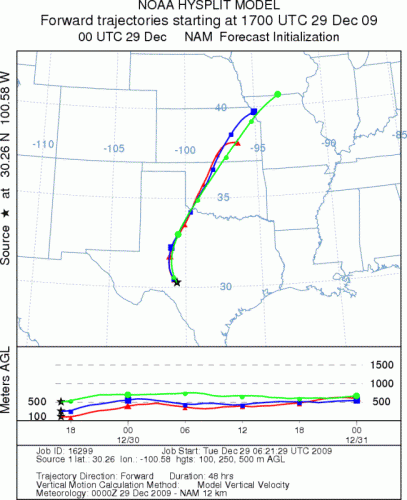
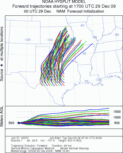
Trajectory Start (s) (shown by *
on map): Austin, TX; Junction, TX; Sonora, TX.
AUSTIN
JUNCTION
SONORA
EDWARDS PLATEAU COMPOSITE
Prepared by: Estelle
Levetin (Faculty of Biological
Science, The
University of Tulsa, 800 S. Tucker Dr., Tulsa, OK 74104) and ) and Peter
K Van de Water (Department of Earth and Environmental Science, California State University Fresno,
2576 East San Ramon Avenue, M/S ST24, Fresno CA 93740-8039). This forecast gives the anticipated future track of
released Mountain Cedar pollen, weather conditions over the region and along the forecast pathway, and an estimated
time of arrival for various metropolitan areas.
Questions: Aerobiology Lab e-mail: pollen@utulsa.edu
Return to Forecasting Home Page