The University of Tulsa
Mountain Cedar Pollen Forecast

Metropolitan Area |
Exposure Risk |
|
Oklahoma City |
Low |
|
Tulsa |
Low |
|
St. Louis MO |
Low |
Date Issued: 30 December 2009
Mountain Cedar Location(s): Arbuckle Mountains, OK
Regional Weather: Tuesday, December 30 TX/OK:
Across the region the weather will warm after yesterdays stormy conditions. Skies will start cloudy but thinning
into the afternoon and tonight. Clear to mostly clear skies are expected tonight, especially to the south and
east of the Edwards Plateau. Temperatures will remain in the 40s across Oklahoma with the chance of snow continuing
today with winds from the south. Across Texas, temperatures are returning into the 50s across the Edwards Plateau
and in the 60s in the edge communities surrounding the Plateau. Winds will be moderate through the day from the
southwest shifting from the west tonight. Winds will decline overnight to light conditions except in the southwestern
region of the Plateau where they will remain moderate. Temperatures will be well below freezing in central Oklahoma
and the mid thirties across the Edwards Plateau. The communities surrounding the Edwards Plateau will drop into
the 40s. Tomorrow, skies will continue to clear with temperatures staying nearly the same. Oklahoma will continue
to have a chance of snow in the morning. Southward, temperatures will be in the 50s across the Edwards Plateau
and 60s in the edge communities. Winds will switch, coming from the northwest at moderate levels. Wednesday night,
skies will be mostly clear across Texas with temperatures below freezing across the Edwards Plateau and mid 30s
to 40s surrounding the Plateau.
Trajectory weather: Partly cloudy skies and moderating temperatures, into the 40s, will occur across Oklahoma
today. This morning there is a chance of snow and drizzle across the area, including the Arbuckle juniper population.
Tonight temperatures will dip into the mid 20s and low 30s from central to southern Oklahoma. Winds will begin
moderate from the south but will shift to a more northerly direction with light to variable winds overnight. Tomorrow,
temperatures in central Oklahoma will be back to the mid 30s and low 40s, southward but with a chance of snow and
rain across the area. Tomorrow night clouds will clear with low temperatures into the lower 20s and winds light
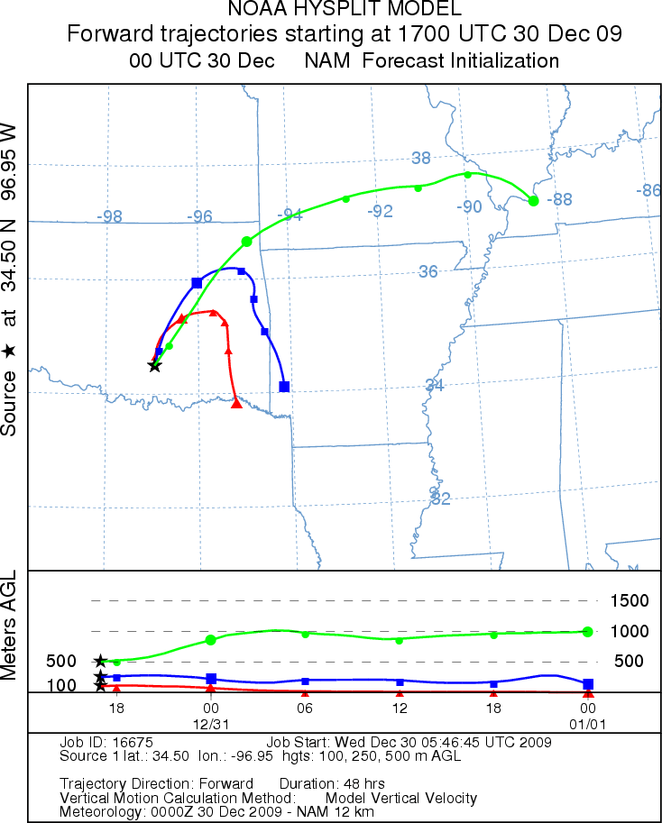
and variable. Today and tomorrow, the trajectories move northward initially, then turn southward over southeastern
Oklahoma. The air at the lower levels is cold and heavy moving across the earths surface during its travel..
OUTLOOK: *** Low Threat today; Low threat tomorrow *** Poor conditions for pollen
release today and Poor conditions tomorrow; Poor conditions for entrainment and transport today, Poor conditions
tomorrow. Cold conditions continue with light and variable winds and cloudy skies along with a continuing
chance of precipitation as snow or sleet this morning and tomorrow morning. near the Arbuckle Mountain population.
The atmosphere will be cold and heavy, travelling near the ground. On Wednesday temperatures will only reach
into the 40s. The cold conditions and upcoming precipitation result in a low threat today and tomorrow. The
cold stable atmospheric conditions and light winds result in poor conditions for entrainment and travel of pollen
away from the Arbuckles Mountain populations. Wednesday night skies will clear and temperatures will drop into
the low 20s.
Trajectory Start (s) (shown by black
star on map): Davis, OK.
Prepared by: Estelle
Levetin
(Faculty
of Biological Science, The University of Tulsa, 800 S. Tucker Dr., Tulsa, OK 74104) and Peter
K Van de Water
(Department of Earth and Environmental Science, California State University Fresno, 2576 East San Ramon Avenue,
M/S ST24, Fresno CA 93740-8039). This forecast gives the anticipated future track of released Mountain Cedar pollen,
weather conditions over the region and along the forecast pathway, and an estimated time of arrival for various
metropolitan areas.
Questions: Aerobiology Lab e-mail: pollen@utulsa.edu
Return to Forecasting Home Page