
The University of Tulsa
Mountain Cedar Pollen Forecast
Metropolitan Area |
Exposure Risk |
|
Dallas/Fort Worth |
Low |
|
Austin |
Moderate |
|
San Antonio |
Moderate |
Date Issued: 22 December 2010
Mountain Cedar Location(s): Edwards Plateau, Texas
Regional Weather:
Wednesday, December 22 - TX/OK: Across the region the
weather will be changing. To the north, cooler conditions and partly cloudy skies will occur with high temperatures
in the 40s today north and reaching into the 50s along the border with Texas. Winds will be from the northeast
at 10 to 15 miles per hour. Overnight the area will have partly cloudy conditions with temperatures in the 20s
and 30s. The border region will be about 10 degrees warmer in the lower 40s. Winds will remain light and variable
over the region. In Texas the Edwards Plateau will be partly cloudy whereas skies will be partly sunny in the
Dallas Ft. Worth region as well as areas around the edge of the Edwards Plateau in Austin and San Antonio. Temperatures
will reach into the mid-60s across the Plateau and cooling into the 50s in the other areas. Winds will be moderate
from the northeast across the area. Tonight conditions will become cloudy with temperatures dipping into the mid-50s
to the east and dropping towards the 30s in the western portion of the Plateau around San Angelo. The edge communities
towards the middle of the Plateau have the potential of drizzle and fog tomorrow morning. Temperatures will stay
about the same as today. Winds will shift coming out of the southeast at low to moderate strength. Tomorrow night
skies will remain cloudy with increasing chances of rain across the region north of Austin and San Antonio. Winds
will be in the 40s to 50s for lows. Winds will remain moderate but shift coming out of the east.
Trajectory weather: Air mass trajectories over the Edwards
Plateau move to the west then begin to move northward as southerly breezes take over late today and overnight.
Partly cloudy skies will occur northward in Oklahoma and across the central Edwards Plateau region today. Temperatures
will be in the mid-50s to mis-60s with moderate breezes. The atmosphere appears to be buoyant and light today
and tomorrow although wind speeds are declining with the trajectories showing an eventual northward pathway across
western Oklahoma. The late movement northward should coincide with increased chances of precipitation tomorrow
across the region and thus not a significant increase in the chance of significant pollen delivery. Tonight temperatures
will cool into the lower 40s and high 30s across most of the Plateau. Increased humidity and chance of drizzle
and fog will occur across most of Texas tonight and tomorrow morning. Overall light to moderate winds will result
in an overall swirling of winds over the Texas region. It is early in the pollination season and the extent of
any current release is unknown although high concentrations have been recorded in a few localities and therefore
exposure may occur in areas that have significant populations of the trees.
OUTLOOK: *** Moderate Threat today and Tomorrow *** Good conditions for pollen release today, decreasing with the
increased chance of precipitation tomorrow. Conditions
for entrainment and transport are moderate both days. Cooling conditions with moderate to light wind speeds will
occur across the Edwards Plateau today. With cool temperatures and moderate wind speeds, the potential of pollen
release is a potential today, especially in those areas where the trees are ready to shed their pollen. However,
the season for pollen release is young and the number of ripe cones is at its beginning. With cool conditions today
and the increasing chance of precipitation tomorrow, pollen cone ripening and release should be restrained. Therefore
the forecast calls for a moderate threat and moderate conditions for release today and tomorrow.
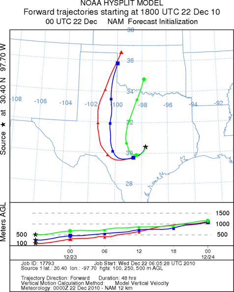
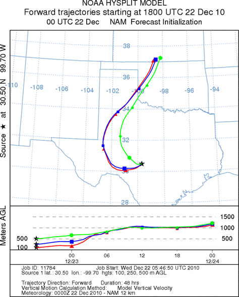
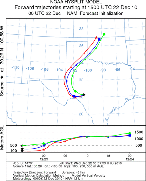
Trajectory Start (s) (shown by *
on map): Austin, TX; Junction, TX; Sonora, TX.
AUSTIN
JUNCTION
SONORA
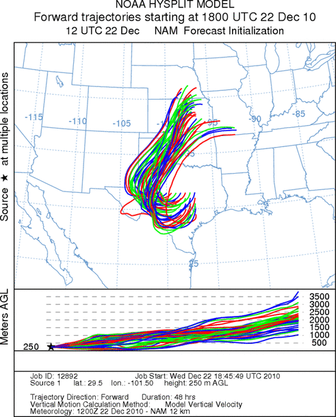
EDWARDS PLATEAU COMPOSITE
Prepared by: Estelle
Levetin (Faculty of Biological
Science, The
University of Tulsa, 800 S. Tucker Dr., Tulsa, OK 74104) and ) and Peter
K Van de Water (Department of Earth and Environmental Science, California State University Fresno,
2576 East San Ramon Avenue, M/S ST24, Fresno CA 93740-8039). This forecast gives the anticipated future track of
released Mountain Cedar pollen, weather conditions over the region and along the forecast pathway, and an estimated
time of arrival for various metropolitan areas.
Questions: Aerobiology Lab e-mail: pollen@utulsa.edu
Return to Forecasting Home Page