
The University of Tulsa
Mountain Cedar Pollen Forecast
Metropolitan Area |
Exposure Risk |
|
Dallas/Fort Worth |
Low |
|
Austin |
Low |
|
San Antonio |
Low |
Date Issued: 24 December 2010
Mountain Cedar Location(s): Edwards Plateau, Texas
Regional Weather:
Friday, December 24 - TX/OK: A
change in the weather will be crossing the region today and tonight with improving conditions tomorrow. To the
north, temperatures will remain in the 40s with light and variable winds and cloudy to partly cloudy skies. Areas
from central Oklahoma towards the Texas border will have periods of drizzle this morning with clearing skies towards
the evening and overnight. Winds will be from the north to northwest at upwards of 10 miles per hour. Tonights
lows will be in the 20s as the skies begin to clear. Winds will remain from the north to northwest at about 10
miles per hour. In Texas cloudy skies today will be accompanied by rain throughout the Dallas/Ft. Worth area south
across the Edwards Plateau towards west Texas. As the system moves through the area today, skies will become partly
cloudy but the chance of thunderstorms increases. Temperatures will be in the 40s towards the border with Oklahoma,
but become warmer to the south. The Edwards Plateau region will be in the 50s and 60s, whereas the edge communities
from Waco to Austin and west to San Antonio will be in the 60s and low 70s. Winds will be shifting from the southeast
towards the North and northwest increasing toward moderate strength. Tonights skies will begin to clear late
with temperatures heading towards the 30s and 40s, especially as the north wind becomes established from the north
bringing colder air to the region. Tomorrow will be sunny with highs only in the 40s and 50s. The winds will
continue from the north becoming stronger during the day. Tomorrow night will see clear skies and the associated
cooling with low temperatures in the 20s across the region. Winds will lighten but stay from the north for the
most part. Early Sunday morning winds in the edge communities will begin to shift coming from the southwest.
Trajectory weather: Air
mass trajectories from the Edwards Plateau, move to the south on northerly winds associated with the weather system
moving across the region. Drizzle and Rain is forecast for the area where the trees are growing. Rain will occur
throughout today with the chance of thunderstorms in the afternoon and evening. As the weather system moves out
of the area cold temperatures will follow dropping tonights lows into the 30s and 40s. In addition, winds will
be moderate to light from the north. Skies will be clearing tomorrow with a reduced chance of rain, but cold conditions
will predominate. Todays temperatures will reach the mid-60s to low 70s, then dip into the 30s overnight and
remain in the 50s tomorrow. Because of the cold, wet conditions little pollen is expected to be released today,
tonight or tomorrow from the Juniper populations. However, past experience suggests that with moisture during
a dry year, next week could see the first significant release of pollen in the region.
OUTLOOK: *** Low Threat today and Tomorrow *** Poor conditions for pollen release today and with condition remaining poor
overnight and tomorrow. Poor conditions for entrainment and transport exist today and tomorrow. Rain along with
conditions getting colder and moderate to light wind speeds, will occur across the Edwards Plateau today. Todays
rain and cool temperatures along with moderate wind speeds, make the potential of pollen release poor today. Cooler,
wet conditions tomorrow, will result in pollen cone ripening and release being minimal. Therefore the forecast
calls for a low threat and poor conditions for pollen release today and tomorrow.
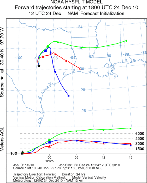
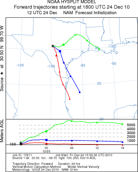
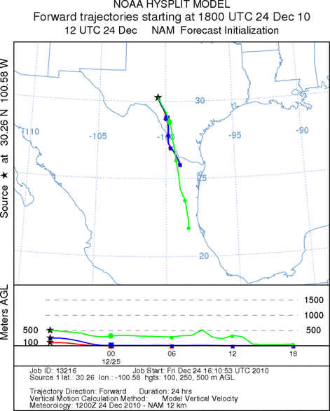
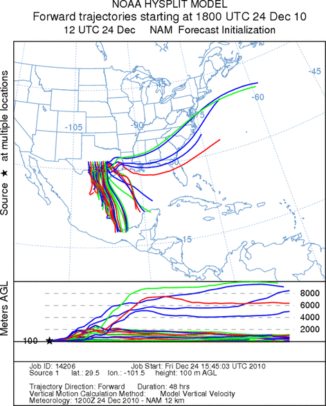
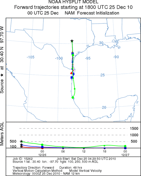
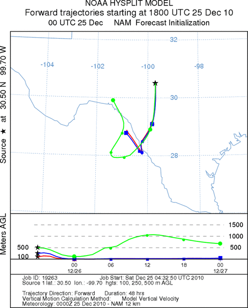
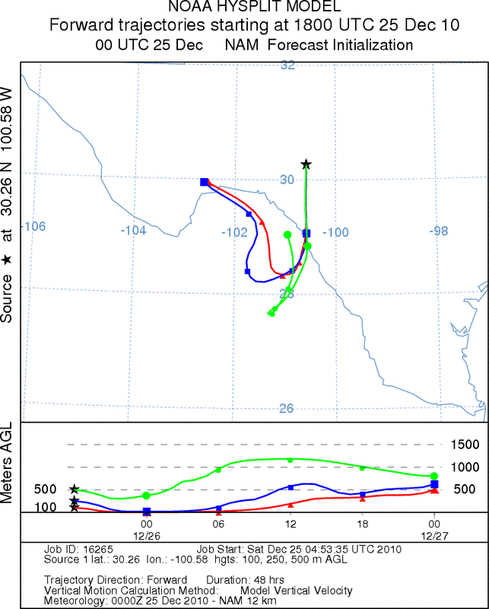
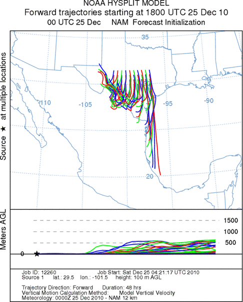
Trajectory Start (s) (shown by *
on map): Austin, TX; Junction, TX; Sonora, TX.
AUSTIN (FRIDAY)
JUNCTION (FRIDAY)
SONORA (FRIDAY)
EDWARDS PLATEAU COMPOSITE (FRIDAY)
AUSTIN (SATURDAY)
JUNCTION (SATURDAY)
SONORA (SATURDAY)
EDWARDS PLATEAU COMPOSITE (SATURDAY)
Prepared by: Estelle
Levetin (Faculty of Biological
Science, The
University of Tulsa, 800 S. Tucker Dr., Tulsa, OK 74104) and ) and Peter
K Van de Water (Department of Earth and Environmental Science, California State University Fresno,
2576 East San Ramon Avenue, M/S ST24, Fresno CA 93740-8039). This forecast gives the anticipated future track of
released Mountain Cedar pollen, weather conditions over the region and along the forecast pathway, and an estimated
time of arrival for various metropolitan areas.
Questions: Aerobiology Lab e-mail: pollen@utulsa.edu
Return to Forecasting Home Page