The University of Tulsa
Mountain Cedar Pollen Forecast

Metropolitan Area |
Exposure Risk |
|
Oklahoma City |
Low |
|
Tulsa |
Low |
|
St. Louis MO |
Low |
Date Issued: 28 December 2010
Mountain Cedar Location(s): Arbuckle Mountains, OK
Regional Weather: Tueesday, December 28 - TX/OK:
The region today will be cool, humid with rain showers in many of the communities especially along the eastern
edge of the Edwards Plateau. In Oklahoma partly cloudy conditions to the north will thicken southward with an
increasing chance of rain. Across the state high temperatures will be in the 50s with winds light and variable
northward but increasing from the south towards the border region with Texas. The Arbuckle Mountain region has
a 20% chance of showers today increasing overnight. Southward in Texas cloudy skies will cover the state with
the chance of rain in most areas. Fog and drizzle will begin the morning in the areas from Dallas southwards along
the east side of the Edwards Plateau. Showers will increase during the day with 50% to 60% chance of rain in most
areas to the east and 20% to 40% in the western areas of the forecast area. Winds across the region will be from
the southeast at 5 to 10. The chance of rain will rise late in the day and overnight with most areas seeing a
significant chance of precipitation. Low temperatures overnight will be very mild in the 40s to the west and
50s to the east. Winds will remain moderate at 5 to 10 miles per hour from the south. Along the Texas border
and southward to Dallas the winds will be from the southeast. Tomorrow, cloudy skies will begin the day with clearing
towards the west in the afternoon. The eastern side of the Edwards Plateau, including the surrounding communities,
will continue to have a significant chance of showers and thunderstorms in the morning. Temperatures will warm
into the mid to upper 60s in the areas with tree populations. Winds will build from the south and southwest at
5 to 15 miles per hour. To the west, winds will blow at stronger levels. Wednesday night mostly clear conditions
return with temperatures dropping into the 40s in most areas and winds will shift coming more from the southwest
at 5 to 10 miles per hour.
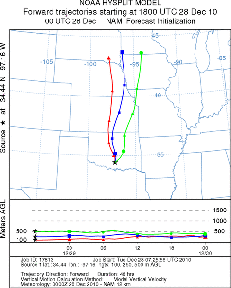
Trajectory weather: Air mass trajectories from the Arbuckle Mountains move due north crossing Oklahoma and
then into Kansas and beyond. The Air mass is stable and thus little lift is associated with the northward pathway.
Cloudy conditions and cool temperatures will occur across the Arbuckle Mountains with a 20% chance of rain today
increasing to 70% tonight. Temperatures will be cool and winds light to moderate from the south. Conditions are
expected to deteriorate overnight with rain and temperatures in the 40s. Tomorrow will continue to be rainy in
the morning but temperatures will climb into the low 60s. There is a 40% chance of rain tomorrow. Wednesday
night will see temperatures in the 40s with a chance of drizzle and fog.
OUTLOOK: *** Low Threat today and Low Threat Tomorrow *** Poor conditions for
pollen release today and tomorrow. Poor conditions for entrainment and transport exist today and tomorrow. Cloudy
conditions with increasing humidity and a 20% chance of rain increasing to 70% tonight before declining to clearing
tomorrow night will provide poor conditions for pollen release, entrainment and travel. Pollen cone ripening and
release should be constrained with the wet conditions. Tonight conditions will continue to deteriorate when the
chance of rain increases significantly. For those reasons the threat tomorrow has been determined to be low.
Trajectory Start (s) (shown by black
star on map): Davis, OK.
Prepared by: Estelle
Levetin
(Faculty
of Biological Science, The University of Tulsa, 800 S. Tucker Dr., Tulsa, OK 74104) and Peter
K Van de Water
(Department of Earth and Environmental Science, California State University Fresno, 2576 East San Ramon Avenue,
M/S ST24, Fresno CA 93740-8039). This forecast gives the anticipated future track of released Mountain Cedar pollen,
weather conditions over the region and along the forecast pathway, and an estimated time of arrival for various
metropolitan areas.
Questions: Aerobiology Lab e-mail: pollen@utulsa.edu
Return to Forecasting Home Page