
The University of Tulsa
Mountain Cedar Pollen Forecast
Metropolitan Area |
Exposure Risk |
|
Dallas/Fort Worth |
High |
|
Austin |
Moderate |
|
San Antonio |
Low |
Date Issued: 30 December 2010
Mountain Cedar Location(s): Edwards Plateau, Texas
Regional Weather: The
region today will be warm with partly to mostly cloudy conditions as a cold system moves southward through the
northern portion of the region brining strong winds and the chance of precipitation tonight. Areas to the south
will have an increased chance of precipitation tomorrow morning and then feel a dip in temperature tomorrow afternoon
and evening. In Oklahoma, partly cloudy to mostly cloudy skies today will occur with temperatures in the low 70s.
Winds will be strong with sustained winds as high as 20 to 25 miles per hour. Tonight the chance of thunderstorms
increases to 40% with temperatures in the lower 40s and a continuation of strong winds from the south. In Texas,
the morning will begin with mostly cloudy skies across the region. Clearing will occur towards the afternoon with
the edge communities breaking into sunny skies. Temperatures will be warm, in the mid 70s, but strong winds from
the south (10-25 mph in areas) will prevail. Overnight the clouds return along with humidity resulting in the
chance of showers and thunderstorms in the edge communities around the Edwards Plateau, northward towards the Dallas/Fort
Worth area and on towards Oklahoma. Winds will remain moderate to strong from the south. In the western region
of central Texas winds will be more from the southwest. Tomorrow, showers in the edge communities northward into
Oklahoma will continue into the morning with 20% to 30% chance of precipitation. Temperatures will cool by slightly
and winds will shift from the previous southern direction to a northwest to westerly direction at moderate levels
on the Plateau. In Oklahoma winds will remain from the southwest until the afternoon when the switch, coming from
the north. Some gustiness is expected throughout the day. Tomorrow night will see partly cloudy conditions region
wide with temperatures in the 20s to 30s from Texas to Oklahoma. Winds will be predominantly from the north
and moderate across the region.
Trajectory weather:
Air mass trajectories from the Edwards Plateau move due north crossing Oklahoma and then into Kansas and beyond
on very strong winds. The due north aspect will develop after noon, thus the Matrix figure shows a more eastward
component to the pathway. The Air mass begins relatively heavy but becomes buoyant and thus lift is associated
with the northward pathway at some distance from the region. Cloudy and mostly cloudy conditions will begin to
break-up and clear this afternoon with warm temperatures, drying conditions and strong winds will occur across
the Edwards Plateau. Cloudy skies will build overnight with an increasing chance of precipitation overnight and
into the morning in the eastern areas from the edge communities into Oklahoma. Winds will continue to be strong.
Tomorrow will continue to be partly cloudy with temperatures cooling reaching the upper 50s and low 60s. A
chance of rain will occur in the morning then clear as the strong southerly winds slacken and reduce the humidity
as northerly winds take over tomorrow evening and overnight.
OUTLOOK: *** High Threat today and Moderate Threat Tomorrow *** Very good conditions for pollen release today and Moderate conditions tomorrow.
Moderate conditions for entrainment and transport exist today and tomorrow. Cloudy to partly cloudy conditions
with strong winds and temperatures in the 70s will occur today across the Edwards Plateau. There is an increase
in humidity tonight with a building chance of showers and thunderstorms. Tomorrow rain will continue in the morning
and then condition clear but become cooler as a storm system crosses the region to the north. Pollination should
occur today with the warm conditions in the areas where the tree population grows. The combination of strong winds
and warm temperatures should aid in the entrainment and long distance travel of pollen from the population northward.
For those reasons a High Threat to communities due north of the population on the Edwards Plateau may be impacted.
If rain overnight occurs broadly entrained pollen will probably be washed from the atmosphere clearing the air.
Additional pollen tomorrow is possible with clearing skies in the afternoon, however the amount should be reduced
and thus only a moderate threat exists.
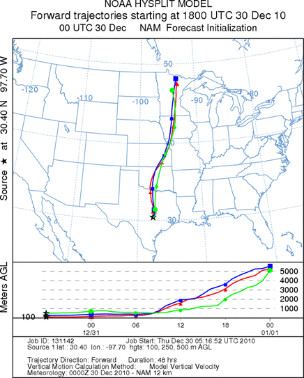
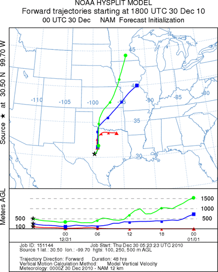
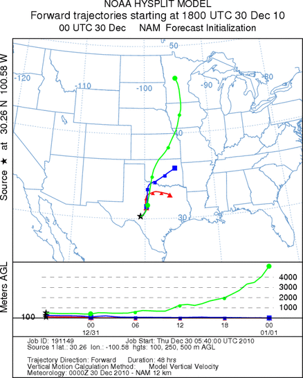
Trajectory Start (s) (shown by *
on map): Austin, TX; Junction, TX; Sonora, TX.
AUSTIN
JUNCTION
SONORA
EDWARDS PLATEAU COMPOSITE
Prepared by: Estelle
Levetin (Faculty of Biological
Science, The
University of Tulsa, 800 S. Tucker Dr., Tulsa, OK 74104) and ) and Peter
K Van de Water (Department of Earth and Environmental Science, California State University Fresno,
2576 East San Ramon Avenue, M/S ST24, Fresno CA 93740-8039). This forecast gives the anticipated future track of
released Mountain Cedar pollen, weather conditions over the region and along the forecast pathway, and an estimated
time of arrival for various metropolitan areas.
Questions: Aerobiology Lab e-mail: pollen@utulsa.edu
Return to Forecasting Home Page