The University of Tulsa
Mountain Cedar Pollen Forecast

Metropolitan Area |
Exposure Risk |
|
Oklahoma City |
Low |
|
Tulsa |
Low |
|
St. Louis MO |
Low |
Date Issued: 31 December 2010
Mountain Cedar Location(s): Arbuckle Mountains, OK
Regional Weather: Friday, December 31 - TX/OK:
The region today will be cooling off as a dominant northerly breeze bring colder air across Oklahoma and into
Texas. Todays temperatures will be moderate but tonight the region will be in the 20s and 30s. Winds will begin
from the west then shift, coming out of the north tonight and tomorrow. Regionally the skies will be partly cloudy
to partly sunny and dry. In Oklahoma todays high temperatures will get into the mid to lower 50s with partly
sunny skies and winds starting from the west but shifting to the north overnight. Winds will be strong this afternoon
with some gustiness but calm into the evening hours and overnight. High temperatures tomorrow will only reach
into the upper 30s to low 40s with clear and sunny conditions in most areas. Saturday night low temperatures are
expected in the teens under clear skies and light winds. Across Texas Temperatures today will be in the lower
60s north to lower 70s along the southern edge of the Edwards Plateau. Skies will be partly sunny to partly cloudy
towards the west although there is no predicted chance of precipitation. Winds will start out lite but build during
the afternoon from the north to northwest, stronger winds are expected in western regions compared to the eastern
edge communities. Tonight lows will be in the upper 20s towards the west and lower 30s towards the east. Winds
will be light and from the north region wide. Tomorrow sunny skies will occur to the east with partly cloudy conditions
west. High temperatures range from the lower 50s to the low 60s with light northerly breezes predominating from
the north. Into the evening skies will clear and cold conditions return with low temperatures in the mid to low
20s in western communities and towards Oklahoma. Low temperatures in the communities surrounding the eastern Edwards
Plateau will be in the upper 20s and low 30s. Winds will remain light but switch from northerly to a northeasterly
and easterly direction
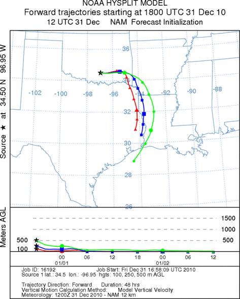
Trajectory weather: Air mass trajectories from the Arbuckle Mountains move east before turning southward
on northerly breezes this afternoon and tonight. Skies will be partly sunny today and tomorrow but temperatures
will be dropping with highs only in the lower 50s today, the upper 30s to low 40s tomorrow and will below freezing
both nights. Winds will be moderate today but falling off as the cold air incursion from the north occurs. The
cold air body will have little buoyancy and thus the entrainment and travel potential of pollen that is release
will be restricted. Conditions tomorrow will deteriorate as the daytime highs are not expected to be much above
the threshold for pollen dispersal. Winds will continue to slacken especially heading into the nighttime hours.
OUTLOOK: *** Low Threat today and Low Threat Tomorrow *** Moderate conditions for pollen release today and
Poor conditions tomorrow. Poor conditions for entrainment and transport exist today and tomorrow. Sunny conditions
but with light winds and temperatures only in the 50s occur today across Oklahoma. The cooling trend will continue
tomorrow as a shot of cold air moves southward across the region. Pollination may occur but with much colder temperatures
than recently and cold dense air, little entrainment and travel is expected. Westerly breezes before the cold
air moves in from the north will take any pollen towards the east and then southward. For these reasons there
is a low threat of pollen to Oklahoma today and tomorrow. Conditions will get colder tomorrow and tomorrow evening.
Trajectory Start (s) (shown by black
star on map): Davis, OK.
Prepared by: Estelle
Levetin
(Faculty
of Biological Science, The University of Tulsa, 800 S. Tucker Dr., Tulsa, OK 74104) and Peter
K Van de Water
(Department of Earth and Environmental Science, California State University Fresno, 2576 East San Ramon Avenue,
M/S ST24, Fresno CA 93740-8039). This forecast gives the anticipated future track of released Mountain Cedar pollen,
weather conditions over the region and along the forecast pathway, and an estimated time of arrival for various
metropolitan areas.
Questions: Aerobiology Lab e-mail: pollen@utulsa.edu
Return to Forecasting Home Page