The University of Tulsa
Mountain Cedar Pollen Forecast

Metropolitan Area |
Exposure Risk |
|
Oklahoma City |
Low |
|
Tulsa |
Low |
|
St. Louis MO |
Low |
Date Issued:20 December 2011
Mountain Cedar Location(s): Arbuckle Mountains, OK
Regional Weather: Tuesday, December 20 TX/OK:
The weather today will be cloudy to the north as the remnants of the yesterdays winter storm continues to move
to the east. Central Oklahoma and northward will continue to have a slight chance of rain and sleet during the
day. Across Texas sunny to partly sunny skies will predominate. Temperatures will be in the lower 50s to the
north, climbing into the lower 60s along the southern edge of the Edwards Plateau communities. Winds across
the region will be moderate from the west to northwest across the area. Tonight partly cloudy skies will return
with temperatures in the mid-20s to the north and west, moderating into the 30s in the edge communities including
San Antonio to Austin and north towards Waco. Winds northward will remain from the west, whereas across Texas
winds will be from the north at moderate levels. Tomorrow morning partly cloudy skies will remain to the north
and along the southern edge of the Edwards Plateau. On the Plateau and to the west mostly to partly sunny skies
will occur. Temperatures across the entire forecast area will be in the 50s. Winds will remain at moderate levels,
from the southwest in the northern areas and out of the south to southeast across the eastern and southern areas
of the Edwards Plateau. Edge communities will begin from the north then the winds will come out of the east later
in the day. Tomorrow night partly cloudy to cloudy conditions will prevail. The Edwards Plateau and to the west
will remain, but the edge communities from San Antonio around to Austin and north toward Dallas has a significant
chance of showers, thunderstorms and rain. These areas will see nighttime temperatures falling into the 40s whereas
the remaining areas to the west will be cooler, into the mid 30s. The precipitation will be moving in on light
easterly winds whereas the drier areas will be predominated by winds from the southwest.
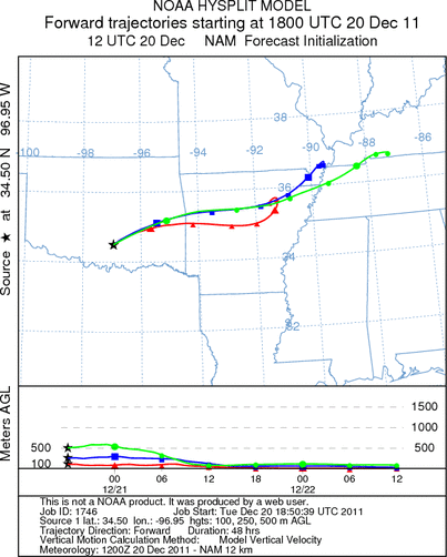
Trajectory weather: Air mass trajectories over Southern Oklahoma move to the east on persistent westerly
winds. Mostly cloudy skies will occur across the Oklahoma region with temperatures only in the upper 40s and
winds from the west at moderate levels (15-20 mph). A chance of rain and sleet occurred in Oklahoma City and northward
today. The atmosphere appears to be stable initially but becomes dense as it travels to the east and flows along
the ground for most of the trajectory pathway. To the south, warmer and sunny conditions will prevail, but northerly
winds will direct those trajectories southward. Tonight temperatures will be in the 20s and low 30s then bounce
back up into the mid 50s tomorrow. Currently there is no indication that the trees in southern Oklahoma are
shedding pollen. There is a trace of pollen showing in the samplers along the southern Edwards Plateau, but no
indication yet of pollen release further north.
OUTLOOK: *** Low Threat today and Tomorrow *** moderate conditions for pollen
release today and tomorrow with poor conditions for entrainment and transport both days. Partly cloudy skies with
cool temperatures and wind from the west will in southern Oklahoma today and tomorrow. There has been a trace
of Juniperus ashei pollen reported in the southern most populations around San Antonio. However there has not
been a significant release yet detected anywhere else. The potential for pollen release is considered poor and
there is no indication that the primary populations have begun releasing pollen..
Trajectory Start (s) (shown by black
star on map): Davis, OK.
Prepared by: Estelle
Levetin
(Faculty
of Biological Science, The University of Tulsa, 800 S. Tucker Dr., Tulsa, OK 74104) and Peter
K Van de Water
(Department of Earth and Environmental Science, California State University Fresno, 2576 East San Ramon Avenue,
M/S ST24, Fresno CA 93740-8039). This forecast gives the anticipated future track of released Mountain Cedar pollen,
weather conditions over the region and along the forecast pathway, and an estimated time of arrival for various
metropolitan areas.
Questions: Aerobiology Lab e-mail: pollen@utulsa.edu
Return to Forecasting Home Page