The University of Tulsa
Mountain Cedar Pollen Forecast

Metropolitan Area |
Exposure Risk |
|
Oklahoma City |
Low |
|
Tulsa |
Low |
|
St. Louis MO |
Low |
Date Issued: 21 Decmber 11
Mountain Cedar Location(s): Arbuckle Mountains, OK
Regional Weather: Wednesday, December 21 TX/OK:
The weather today will remain partly cloudy to the north as well as across the western portions of Texas. Sunny
conditions will prevail in the Dallas area but along the eastern edge of the Edwards Plateau mostly cloudy skies
will occur. Temperatures will be seasonally warm with highs in the mid to upper 50s in most areas. Winds will
be from the west and southwest to the north and from the southeast to east across the southern and western areas
of the Plateau. Overnight partly to mostly cloudy conditions will build with an increasing chance of rain (70%)
across the southern edge communities between San Antonio and Austin. The chance of rain diminishes towards the
north, however Dallas will have a 30% chance of showers. A 20% chance of precipitation will occur across the Plateau.
Temperatures will drop to the mid 30s to the west and the low to mid 40s in the edge communities. Winds will
remain from the southwest over the Plateau whereas from San Antonio to Austin and north to Dallas winds will begin
from the east to southeast, switching to a more northerly direction after midnight. Tomorrow will be mild and
warmer across the southern regions but cool across Oklahoma. In Oklahoma mostly to partly cloudy conditions will
begin the day with increasing clouds into the evening. Temperatures will be in the upper 40s to low 50s with
a southwest wind of 10 mph. Overnight cloudy skies will prevail, temperatures will be in the mid 20s to low 30s
and there is a 20% chance of rain along the OK/TX border changing to a rain and snow mix further north. Tomorrow
in Texas conditions will be partly sunny to sunny in the Dallas area with increasing cloudiness towards the west
and south. Both San Antonio and Austin will have lingering showers with a 20% to 40% chance of precipitation.
Temperatures will be in the 60s across the region with northwest winds of 5 to 10 mph. Tomorrow night partly
to mostly cloudy skies will build in, with temperatures in the lower 30s to the west and lower 40s in other areas.
Winds will be from the north across the Edwards Plateau region.
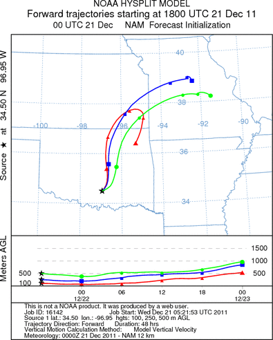
Trajectory weather: Air mass trajectories over Southern Oklahoma move to the north on persistent southerly
winds. Partly cloudy skies will occur across the Oklahoma region with temperatures in the mid 50s and winds from
the southwest at light to moderate levels (~10 mph). Tonight partly cloudy skies will remain with temperatures
in the low to mid 30s cooling towards the north. Light and variable winds will be maintained overnight. Tomorrow
mostly cloudy to partly cloudy conditions will remain. Temperatures will cool with central Oklahoma only reaching
the mid-40s, and low 50s towards the border with Texas. Winds will pick up coming from the northeast at 10 to
15 mph. Tomorrow night cloudy skies will build with a 20% chance of precipitation. To the north the chance of
the precipitation being snow increases. Winds will be from the north at 10 to 15 mph. Currently there is no indication
that the trees in southern Oklahoma are shedding pollen. There is a trace of pollen showing in the samplers along
the southern Edwards Plateau, but no indication yet of pollen release further north.
OUTLOOK: *** Low Threat today and Tomorrow *** moderate conditions for pollen
release today and poor conditions tomorrow with poor conditions for entrainment and transport both days. Currently
there is no indication that the trees in southern Oklahoma are shedding pollen. There is a trace of pollen showing
in the samplers along the southern Edwards Plateau, but no indication yet of pollen release further north. Partly
cloudy skies with cool temperatures and wind from the southwest will occur in southern Oklahoma today. Tomorrow
mostly cloudy conditions will prevail building towards a chance of precipitation. To the north the moisture may
fall as snow, whereas along the border with Texas it is more likely to be in the form of rain. There has been
a trace of Juniperus ashei pollen reported in the southern most populations around San Antonio. However there
has not been a significant release yet detected anywhere else. The potential for pollen release is considered
poor and there is no indication that the primary populations have begun releasing pollen.
Trajectory Start (s) (shown by black
star on map): Davis, OK.
Prepared by: Estelle
Levetin
(Faculty
of Biological Science, The University of Tulsa, 800 S. Tucker Dr., Tulsa, OK 74104) and Peter
K Van de Water
(Department of Earth and Environmental Science, California State University Fresno, 2576 East San Ramon Avenue,
M/S ST24, Fresno CA 93740-8039). This forecast gives the anticipated future track of released Mountain Cedar pollen,
weather conditions over the region and along the forecast pathway, and an estimated time of arrival for various
metropolitan areas.
Questions: Aerobiology Lab e-mail: pollen@utulsa.edu
Return to Forecasting Home Page