
The University of Tulsa
Mountain Cedar Pollen Forecast
Metropolitan Area |
Exposure Risk |
|
Dallas/Fort Worth |
Low |
|
Austin |
Low |
|
San Antonio |
Low |
Date Issued: 22 December 2011
Mountain Cedar Location(s): Edwards Plateau, Texas
Regional Weather: Thursday, December 22 TX/OK:
The weather today will remain seasonally cool across Oklahoma with mostly cloudy skies and temperatures in the
upper 40s to low 50s across the region. Winds will start light but increase to moderate conditions from the
northeast this afternoon. To the south sunny and mostly sunny conditions will prevail across the Edwards Plateau.
Only in Austin to San Antonio region will lingering morning showers threaten. A 30% chance of showers exists
for Austin this morning whereas the San Antonio area has a 20% chance. Skies in these areas should clear into
the afternoon. Temperatures will be warm and in the 60s in most areas. The southernmost edge communities may
reach 70 this afternoon. Tonight partly cloudy to cloudy conditions will build again with temperatures dropping
into the low 40s in the edge communities and into the 30s on the Edwards Plateau. Winds will remain moderate
(10 20 mph) from the north across the region. Tomorrow temperatures drop back into the 40s and low 50s region
wide. In Oklahoma partly cloudy skies will occur with temperatures near 40 and a northerly wind. In Texas mostly
cloudy conditions will prevail in the edge communities with cloudy skies over the Edwards Plateau. Temperatures
will reach into the low 50s in the San Antonio region, otherwise temperatures in the 40s will be the rule. Winds
will increase their strength (15-20 mph) and remain from the north to northeast. Tomorrow night temperatures will
dip into the upper 30s along the edge of the Edwards Plateau and cool to the upper 20s across the Edwards Plateu.
Cloudy skies and a 20% chance of snow is forecast towards the west, with rain and rain showers possible on the
eastern Plateau and in the edge communities. Winds will return to moderate conditions and remain from the north
to northeast.
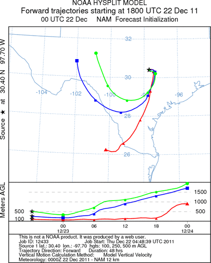
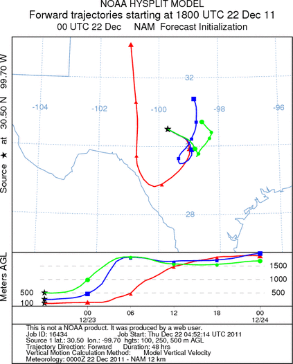
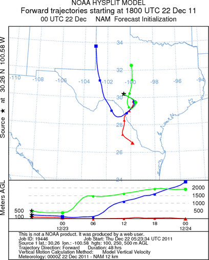
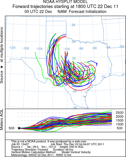
Trajectory weather: Air mass trajectories over the Edwards Plateau moves northward on southeasterly winds,
moving north over Oklahoma in the next 24 to 48 hours. Winds will not be strong in the next 48 hours thus the
trajectories will remain relatively close. Mostly cloudy and partly cloudy skies with seasonal temperatures in
the 50s and low 60s will occur today. Tonight skies will be partly to mostly cloudy in the edge communities
with a significant chance of precipitation tonight from San Antonio, north into the Dallas area. The atmosphere
appears relatively stable for the next 12 to 24 hours with the trajectories then rising after that. Tomorrow the
day will begin similarly, but with some clearing to the north and in the edge communities. Temperatures will rise
into the 60s with a dominant moderate northwest wind over the region. Tomorrow night temperatures will be close
to freezing over the Plateau, with warmer temperatures in the 40s in the edge communities north toward the Dallas/Fort
Worth regional area. Wind will remain moderate from the North.
OUTLOOK: *** Low Threat today and Tomorrow *** moderate conditions for pollen
release today with poor conditions tomorrow with moderate conditions for entrainment and transport but poor conditions
tomorrow. Partly to mostly sunny skies today with a chance of showers this AM in the southern edge communities.
Temperatures will be warm, in the 60s to low 70s. Winds will swirl over central Texas throughout the day with
a dominant northerly wind taking over this afternoon and into the evening. Tomorrow will be much cooler with cloudy
skies and increasing northerly winds. Tomorrow night most of the Plateau will have a chance of rain to the east
and snow showers to the west. There continues to be a trace of Juniperus ashei pollen reported in the southern
most populations around San Antonio. Showers overnight may have washed most of it out of the atmosphere, but with
warm conditions a moderate level may be present today. In other areas, however, there has not been a significant
release yet detected. The potential for pollen release is thought to be just starting but there is no indication
that the primary populations have begun releasing pollen.
Trajectory Start (s) (shown by *
on map): Austin, TX; Junction, TX; Sonora, TX.
AUSTIN
JUNCTION
SONORA
EDWARDS PLATEAU COMPOSITE
Prepared by: Estelle
Levetin (Faculty of Biological
Science, The
University of Tulsa, 800 S. Tucker Dr., Tulsa, OK 74104) and ) and Peter
K Van de Water (Department of Earth and Environmental Science, California State University Fresno,
2576 East San Ramon Avenue, M/S ST24, Fresno CA 93740-8039). This forecast gives the anticipated future track of
released Mountain Cedar pollen, weather conditions over the region and along the forecast pathway, and an estimated
time of arrival for various metropolitan areas.
Questions: Aerobiology Lab e-mail: pollen@utulsa.edu
Return to Forecasting Home Page