
The University of Tulsa
Mountain Cedar Pollen Forecast
Metropolitan Area |
Exposure Risk |
|
Dallas/Fort Worth |
Low |
|
Austin |
Low |
|
San Antonio |
Low |
Date Issued: 24 December 2011
Mountain Cedar Location(s): Edwards Plateau, Texas
Regional Weather: Saturday, December 24/ Sunday, December
25 TX/OK: The weather today will be cool and cloudy. Rain is forecast across most of the region, starting
at the Oklahoma/Texas border southward across Texas. The chance of rain will be around 20% in southern Oklahoma
rising to 100% in the edge communities surrounding the southern and eastern Edwards Plateau. High temperatures
today will be in the mid to upper 40s north, and in the 30s most of the day across the western communities of
the Edwards Plateau. The western areas of Texas may see a rain and snow mix. In Oklahoma, winds will be light
and variable. Across Texas winds will be light to moderate (10 to 15 mph) from the north. Temperatures will be
in the low to mid 40s across Oklahoma as well as much of Texas. The western portions of the area will be in the
low 40s to upper 30s. Tonight, temperatures will fall into the 30s in most areas, while those that were only
in the 30s during the day will fall into the 20s. Precipitation will continue through the night with rain in
the edge communities and a chance of rain and snow across the Plateau. Winds will remain light and variable to
the north and moderate elsewhere. The winds will remain from the north. On Christmas day, mostly cloudy skies
will occur across Oklahoma, southward into Texas especially along the eastern areas surrounding the Edwards Plateau.
The western Edwards Plateau will be cloudy but with no chance of rain. The chance of precipitation will remain
across the other areas including the southern edge communities such as San Antonio, especially in the morning then
beginning to clear after noon. Temperatures will warm into the low 50s in the edge communities whereas the Plateau
communities will remain in the 40s. Winds will remain from the north and northwest at moderate levels. Christmas
night, skies will start to clear. A slight chance of rain will exist in the northern communities including areas
of Oklahoma and north Texas. The rest of the region will be clearing with temperatures in the mid 30s to the
east and mid 20s across the Edwards Plateau.
Trajectory weather: Air mass trajectories over the Edwards Plateau moves southward on north to northeasterly
winds, moving across south Texas into Mexico and over the Gulf of Mexico. Winds will be moderate and steady over
the next 48 hours. Cloudy and mostly cloudy skies with cold temperatures in the 40s will dominate today with the
chance of precipitation over the entire Juniperus ashei population in Oklahoma and Texas. Tonight skies will remain
cloudy with precipitation, especially in the edge communities northwards toward the Oklahoma border. Tomorrow
the day will begin with lingering showers in the edge communities towards north Texas. Winds will remain at moderate
levels from the north to northeast and temperatures will warm a bit, with highs expected in the mid 40s to low
50s in the edge communities but remaining in the 40s on the Plateau and to the west. Tomorrow night temperatures
will return to the 30s across the region, with below freezing conditions to the west. Winds will remain moderate
from the North to northwest.
OUTLOOK: *** Low Threat today and Tomorrow *** poor conditions for pollen release today and tomorrow with
poor conditions for entrainment and transport as well. Cloudy skies today and tomorrow with precipitation building
today, rain tonight and some residual showers into tomorrow morning. High temperatures will only reach into the
30s and 40s across the region. Winds will move the trajectories to the south, southwest over the next 48 hours.
Tomorrow will be a bit warmer with cloudy skies and lingering showers, the precipitation will finally diminish
tomorrow night. Although a trace of Juniperus ashei pollen has been reported in the southern most populations around
San Antonio, poor conditions for release, cold air temperatures and precipitation make for very poor conditions
for any kind of pollen release as well as entrainment and travel.
OUTLOOK: *** ------ Threat today ***
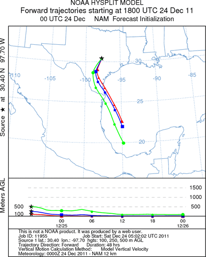
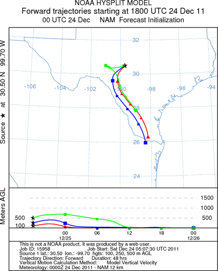
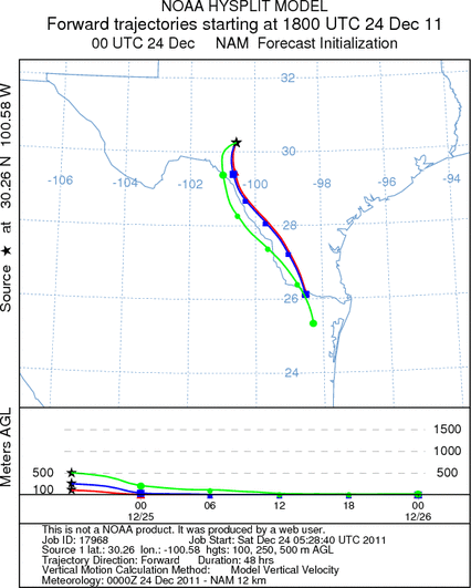
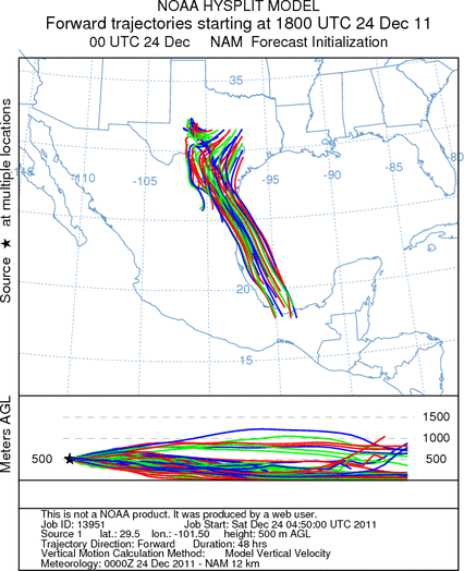
Trajectory Start (s) (shown by *
on map): Austin, TX; Junction, TX; Sonora, TX.
AUSTIN
JUNCTION
SONORA
EDWARDS PLATEAU COMPOSITE
Prepared by: Estelle
Levetin (Faculty of Biological
Science, The
University of Tulsa, 800 S. Tucker Dr., Tulsa, OK 74104) and ) and Peter
K Van de Water (Department of Earth and Environmental Science, California State University Fresno,
2576 East San Ramon Avenue, M/S ST24, Fresno CA 93740-8039). This forecast gives the anticipated future track of
released Mountain Cedar pollen, weather conditions over the region and along the forecast pathway, and an estimated
time of arrival for various metropolitan areas.
Questions: Aerobiology Lab e-mail: pollen@utulsa.edu
Return to Forecasting Home Page