
The University of Tulsa
Mountain Cedar Pollen Forecast
Metropolitan Area |
Exposure Risk |
|
Dallas/Fort Worth |
Moderate |
|
Austin |
Moderate |
|
San Antonio |
Moderate |
Date Issued: 29 December 2011
Mountain Cedar Location(s): Edwards Plateau, Texas
Regional Weather: -Thursday, December 29 TX/OK:
The region will remain dominated by sunny skies and warm temperatures with readings in the mid to upper 60s and
lower 70s across the region. Oklahoma City is expected to reach the upper 60s today, to the south on the central
Edwards Plateau will be in the low 70s. Winds today will be from the south to southwest at light levels. The
Western Edwards Plateau will increase those winds to moderate levels this afternoon. Surrounding the Edwards
Plateau, winds will be light from the northwest, then switching out of the southwest this afternoon. Tonight clear
skies will prevail with all areas in the mid 30s or above freezing, except for the southwestern Edwards Plateau
communities. In the western areas temperatures will be in the low 30s at freezing. Winds will calm overnight
with light and variable conditions to the north and a southwestern flow over the southern areas. Tomorrow sunny
and warmer conditions will continue with a slight rise in temperatures resulting in the southern communities as
well as the edge communities reaching the lower 70s. To the north in Oklahoma temperatures in the upper 60s
are expected. Winds will remain light (5 to 10 mph) shifting and coming from the north, except for the edge communities
where a light westerly wind will start in the morning but come from the south after noon. Tomorrow night clear
skies will occur. There is a chance of increasing fog along the southern and eastern edge of the Edwards Plateau.
Temperatures will remain above freezing.
Trajectory weather: Air mass trajectories over the central and eastern Edwards Plateau move toward the northeast
and then eastward, especially at the highest levels of the atmosphere. At ground level light winds over the forecast
period will cause the trajectories to not move extensively. Winds over the region are stable thus any pollen in
the atmosphere will have a greater chance of being deposited and/or removed by impaction on nearby vegetation.
Any pollen entrained and lifted to high levels have a chance to move significantly towards the east on upper level
westerly winds. Dry conditions will prevail today and tomorrow, with a dry forecast for the rest of the week
and into the weekend. Tomorrow the day will dawn with sunny skies and temperatures will build to slightly warmer
readings than today with highs in the upper 60s to low 70s in most places. Tomorrow night temperatures will
return to the mid 30s to upper 40s across the region with a chance of morning fog in the edge communities Saturday
morning.
OUTLOOK: *** Moderate Threat today and Moderate Threat Tomorrow *** Moderate conditions
for pollen release today and moderate conditions tomorrow with good conditions for entrainment and transport.
Clear skies today and tomorrow with temperatures warming and moderate winds across the region are expected. High
temperatures will reach into the upper 60s to low 70s across the region today and tomorrow. Upper level winds
will move the trajectories across eastern Texas. At lower levels most trajectories remain within the state relatively
close to emmission Over the next 48 hours stable atmospheric conditions will continue over Texas. Although only
a trace of Juniperus ashei has been recorded high levels may be experienced. Many areas continue to not show
pollen release therefore a moderate threat occurs. However in areas surrounding the Edwards Plateau pollen has
been reported with higher levels yesterday in the Waco area, as well as continued small amounts in the other edge
communities suggesting that the season is ramping up.
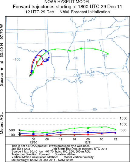
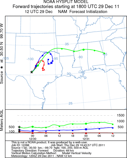
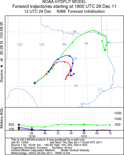
Trajectory Start (s) (shown by *
on map): Austin, TX; Junction, TX; Sonora, TX.
AUSTIN
JUNCTION
SONORA
EDWARDS PLATEAU COMPOSITE
Prepared by: Estelle
Levetin (Faculty of Biological
Science, The
University of Tulsa, 800 S. Tucker Dr., Tulsa, OK 74104) and ) and Peter
K Van de Water (Department of Earth and Environmental Science, California State University Fresno,
2576 East San Ramon Avenue, M/S ST24, Fresno CA 93740-8039). This forecast gives the anticipated future track of
released Mountain Cedar pollen, weather conditions over the region and along the forecast pathway, and an estimated
time of arrival for various metropolitan areas.
Questions: Aerobiology Lab e-mail: pollen@utulsa.edu
Return to Forecasting Home Page