The University of Tulsa
Mountain Cedar Pollen Forecast

Metropolitan Area |
Exposure Risk |
|
Oklahoma City |
Low |
|
Tulsa |
Low |
|
St. Louis MO |
Low |
Date Issued: 30 December 2011
Mountain Cedar Location(s): Arbuckle Mountains, OK
Regional Weather: Friday, December 30 TX/OK:
The region will remain dominated by sunny skies and warm temperatures with readings in the mid to upper 60s and
lower 70s. Oklahoma City is expected to remain in the 60s today, to the south on the central Edwards Plateau
temperatures will be in the upper 60s and low 70s as well. Winds today will be from the north at light levels
across Texas and more moderate strengths in Oklahoma. Surrounding the Edwards Plateau, winds will be light from
the northwest, switching to a more northerly direction this afternoon. Tonight mostly clear skies will prevail
with most areas in the mid 30s on the Edwards Plateau. Some areas may flirt with the freezing level, however,
temperatures in most areas are expected to bottom out above the freezing mark. In the surrounding edge communities
temperatures will only dip into the mid 40s. Winds will be calm overnight with light and variable conditions
to the north and a northeasterly flow over Texas. As morning approaches a more dominant southerly flow will become
established. Tomorrow, partly cloudy skies will occur across Oklahoma with sunny skies to the south across Texas.
However, tomorrow morning fog is expected in the edge communities. Warmer temperatures will occur with most of
Texas being in the mid to lower 70s for the high temperatures. To the north Oklahoma is expected to be in the
mid 60s. Winds will continue from the south to southwest with wind speeds building to moderate conditions during
the day. Tomorrow night, clear to mostly clear skies will occur in most areas, however, partly cloudy conditions
with fog building overnight is expected again in the edge communities. Low temperatures will be seasonally warm
with temperatures in the mid to upper 30s on the Plateau while the surrounding edge communities such as San Antonio
and Austin will struggle to get below 50. Overnight winds will increase and switch from the southerly flow to
a more northerly flow. By Saturday morning wind gusts up to 25 miles per hour are expected across the region.
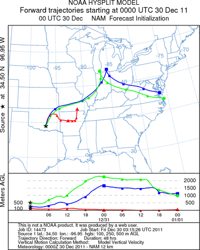
Trajectory weather: Trajectory weather: Air mass trajectories from southern Oklahoma move very slowly northeastward
then eastward towards Arkansas through central Oklahoma. The trajectory shows the disparity between the surface
winds versus those at higher elevations. The higher elevations move rapidly towards the northeast similar to yesterdays
overall flow. Very light winds at the surface will retard any entrainment and travel from the southern Oklahoma
population. Tonight light and variable winds will remain. Today skies will be sunny with warm conditions, high
temperatures expected to be in the mid to upper 60s. Tomorrow skies will become partly cloudy but warm conditions
will remain with temperatures in the upper 60s. Overnight winds will pick-up and switch to a southerly flow.
OUTLOOK: *** Moderate Threat today and Moderate Threat Tomorrow *** Good conditions
for pollen release today and tomorrow with Poor conditions today but Good conditions tomorrow for entrainment and
transport. Clear skies today with warming conditions will provide good conditions for pollination. However, winds
will start at light levels from the north today, switching to a southerly flow early as the wind speed dies to
light and variable conditions tonight. Temperatures will be in the mid to upper 60s today and upper 30s tonight.
Tomorrow temperatures will warm into the upper 60s across the region as southerly winds bring warm air to the
region. Partly cloudy skies are expected. Good conditions exist for pollination today and tomorrow, however,
a check on the southern population trees yesterday, showed no pollen release currently ongoing. In addition, very
light winds will hamper any entrainment and travel if pollen is released into the atmosphere. We wait for a clear
signal of pollen dispersal from the southern Oklahoma population. Although the good conditions in the next few
days may mark pollination initiation, todays light winds will reduce and long distance travel. Communities in
Oklahoma near the populations may be impacted with increasing juniper pollen in the atmosphere, but it should be
limited today. We will list today, as moderate but with better conditions and confirmation of the pollination
season beginning a more significant threat will occur.
Trajectory Start (s) (shown by black
star on map): Davis, OK.
Prepared by: Estelle
Levetin
(Faculty
of Biological Science, The University of Tulsa, 800 S. Tucker Dr., Tulsa, OK 74104) and Peter
K Van de Water
(Department of Earth and Environmental Science, California State University Fresno, 2576 East San Ramon Avenue,
M/S ST24, Fresno CA 93740-8039). This forecast gives the anticipated future track of released Mountain Cedar pollen,
weather conditions over the region and along the forecast pathway, and an estimated time of arrival for various
metropolitan areas.
Questions: Aerobiology Lab e-mail: pollen@utulsa.edu
Return to Forecasting Home Page