
The University of Tulsa
Mountain Cedar Pollen Forecast
Metropolitan Area |
Exposure Risk |
|
Dallas/Fort Worth |
High |
|
Austin |
High |
|
San Antonio |
High |
Date Issued: 30 December 2011
Mountain Cedar Location(s): Edwards Plateau, Texas
Regional Weather: Friday, December 30 TX/OK:
The region will remain dominated by sunny skies and warm temperatures with readings in the mid to upper 60s and
lower 70s. Oklahoma City is expected to remain in the 60s today, to the south on the central Edwards Plateau
temperatures will be in the upper 60s and low 70s as well. Winds today will be from the north at light levels
across Texas and more moderate strengths in Oklahoma. Surrounding the Edwards Plateau, winds will be light from
the northwest, switching to a more northerly direction this afternoon. Tonight mostly clear skies will prevail
with most areas in the mid 30s on the Edwards Plateau. Some areas may flirt with the freezing level, however,
temperatures in most areas are expected to bottom out above the freezing mark. In the surrounding edge communities
temperatures will only dip into the mid 40s. Winds will be calm overnight with light and variable conditions
to the north and a northeasterly flow over Texas. As morning approaches a more dominant southerly flow will become
established. Tomorrow, partly cloudy skies will occur across Oklahoma with sunny skies to the south across Texas.
However, tomorrow morning fog is expected in the edge communities. Warmer temperatures will occur with most of
Texas being in the mid to lower 70s for the high temperatures. To the north Oklahoma is expected to be in the
mid 60s. Winds will continue from the south to southwest with wind speeds building to moderate conditions during
the day. Tomorrow night, clear to mostly clear skies will occur in most areas, however, partly cloudy conditions
with fog building overnight is expected again in the edge communities. Low temperatures will be seasonally warm
with temperatures in the mid to upper 30s on the Plateau while the surrounding edge communities such as San Antonio
and Austin will struggle to get below 50. Overnight winds will increase and switch from the southerly flow to
a more northerly flow. By Saturday morning wind gusts up to 25 miles per hour are expected across the region.
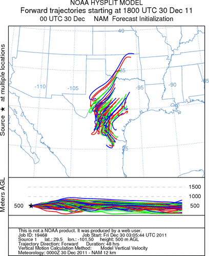
Trajectory weather: Air mass trajectories over the central and eastern Edwards Plateau move toward the southwest
on a dominant northeast flow over the region. At the surface light winds will cause most pollen to be constrained
to a fairly local travel distance. Winds will be stronger at higher levels, but with poor conditions resulting
in entrainment pollen travel over long distances is ruled out for the most part. Winds over the region are stable
thus any pollen in the atmosphere will have a greater chance of being deposited and/or removed by impaction on
nearby vegetation. Any pollen entrained and lifted to high levels have a chance to move significantly towards
the northeast on upper level southwesterly winds. Dry conditions will prevail today and tomorrow, with a dry
forecast for the rest of the week and into the weekend. Tomorrow the day will dawn with sunny skies and temperatures
will build to slightly warmer readings than today with highs in the upper 60s to low 70s in most places. Tomorrow
night temperatures will return to the mid 30s to upper 40s across the region with a chance of morning fog in
the edge communities Saturday morning.
OUTLOOK : *** Moderate to Significant Threat today and Significant
Threat Tomorrow *** Moderate conditions for pollen release today and Good conditions tomorrow with moderate
conditions today and good conditions tomorrow for entrainment and transport. Clear skies today and tomorrow with
temperatures warming but with light winds across the region are expected. High temperatures will reach into the
upper 60s to low 70s across the region today and tomorrow. Ground level trajectories will move towards the south
on light northerly winds. Towards the west side of the Plateau winds will begin to shift, coming from the southwest,
therefore some westernmost trajectories may turn and start to flow towards the northeast. Todays and tonights
light wind level will result in most trajectories remaining relatively close within the state Over the next 24+
hours stable atmospheric conditions will occur over Texas. Increasing amounts of Juniperus ashei pollen are being
reported with the highest levels recorded in the edge communities from Waco to Austin and onward toward San Antonio.
Many areas continue to not show pollen release therefore a moderate threat occurs over the region. However in
areas surrounding the Edwards Plateau high levels may be experienced. The warm conditions today are perfect for
cone ripening, however the light winds in the area should result in moderate concentrations in the atmosphere.
Tomorrow winds will move into the area, therefore tomorrow significant concentrations are expected.
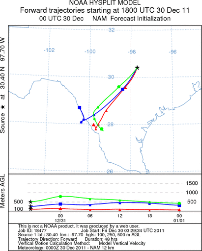
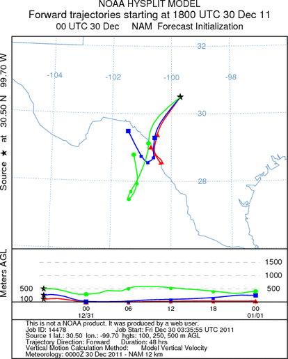
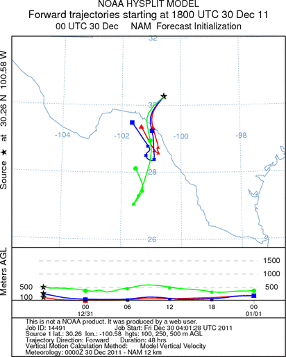
Trajectory Start (s) (shown by *
on map): Austin, TX; Junction, TX; Sonora, TX.
AUSTIN
JUNCTION
SONORA
EDWARDS PLATEAU COMPOSITE
Prepared by: Estelle
Levetin (Faculty of Biological
Science, The
University of Tulsa, 800 S. Tucker Dr., Tulsa, OK 74104) and ) and Peter
K Van de Water (Department of Earth and Environmental Science, California State University Fresno,
2576 East San Ramon Avenue, M/S ST24, Fresno CA 93740-8039). This forecast gives the anticipated future track of
released Mountain Cedar pollen, weather conditions over the region and along the forecast pathway, and an estimated
time of arrival for various metropolitan areas.
Questions: Aerobiology Lab e-mail: pollen@utulsa.edu
Return to Forecasting Home Page