The University of Tulsa
Mountain Cedar Pollen Forecast

Metropolitan Area |
Exposure Risk |
|
Oklahoma City |
Low |
|
Tulsa |
Moderate |
|
St. Louis MO |
Low |
Date Issued: 31 December 2011
Mountain Cedar Location(s): Arbuckle Mountains, OK
Regional Weather: Saturday/Sunday, December 31/January
1 TX/OK: The region will remain dominated by sunny skies and warm temperatures today with readings in the mid
to lower 70s. Oklahoma City is expected to reach into the mid 70s today as will areas to the south along the
Texas/Oklahoma border region. To the south on the central Edwards Plateau temperatures will be in the upper 70s
to the east as well as in the surrounding edge communities. Communities to the west will reach into the mid 70s.
Winds today will be from the south to the southwest across the western areas of central Texas. To the north
in Oklahoma winds will be strong, but slacken to the south towards Texas. As the afternoon progresses a change
will begin in the west as a northerly wind regime takes over. This change will bring light to moderate wind conditions
starting north and west with the change occurring across the Edwards Plateau this evening around the time of the
New Year. Temperatures will remain above freezing across the region with lows mostly in the mid 30s to mid-40.
The shift in winds will signal a significant shift towards colder temperatures. On Sunday sunny skies will continue
to dominate the region, however high temperatures will only reach into the upper 50s and low 60s in the warmer
areas of the forecast region. Winds will be primarily from the north to northeast across the area at moderate
levels. Tomorrow night Oklahoma temperatures will drop into the upper 20s to low 30s across the southern portion
of the state. In Texas mid to low 30s will occur in the areas surrounding the Edwards Plateau, whereas the Plateau
itself will see temperatures return back to the mid 20s. Winds will calm but remain from the north and northeast.
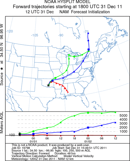
Trajectory weather: Trajectory weather: Air mass trajectories from southern Oklahoma move very slowly northeastward
then eastward towards Arkansas through central Oklahoma. The trajectory shows a disparity between the surface
winds versus those at higher elevations. The higher elevations move rapidly towards the northeast similar to yesterdays
overall flow. Light to moderate winds at the surface will result in entrainment and if the air is buoyant enough
to move the pollen up in the atmosphere then travel will occur from the southern Oklahoma population rapidly northeast.
Tonight winds will remain moderate as the front moves through the area. Today skies will be sunny with warm conditions,
high temperatures expected to be in the mid 70s. Tomorrow skies will remain sunny but cool conditions will return
with highs in the mid to low 50s. On Sunday winds will continue from the north to northwest at light to moderate
levels. Overnight, winds will calm to light and variable conditions across the southern Oklahoma juniper population.
OUTLOOK: *** Moderate Threat today and Low Threat Tomorrow
*** Good conditions for pollen release today and moderate to poor conditions tomorrow with Good conditions
today but Poor conditions tomorrow for entrainment and transport. Clear skies today with warm conditions will
provide good conditions for pollination. Winds will be at moderate levels from the southwest today, switching
to a northerly flow overnight. Temperatures will be in the mid 70s today but return to the lower 30s tonight
as winds switch coming out of the north to northeast. Tomorrow temperatures will cool into the 50s across the
region as northerly winds bringing colder air to the area. Sunny skies will remain across the region. Good conditions
exist for pollination today and tomorrow, however, a check on the southern population trees recently, showed no
pollen release currently ongoing. We wait for a clear signal of pollen dispersal from the southern Oklahoma population.
Although good conditions exist today, we continue to wait for signals that will show pollination initiation.
Communities in Oklahoma near the populations may be impacted with increasing juniper pollen in the atmosphere,
but it should be limited as the surface winds will be moving relatively slowly. We will list today, as moderate,
however we wait for better conditions and confirmation of the pollination season beginning before a more significant
threat will occur.
Trajectory Start (s) (shown by black
star on map): Davis, OK.
Prepared by: Estelle
Levetin
(Faculty
of Biological Science, The University of Tulsa, 800 S. Tucker Dr., Tulsa, OK 74104) and Peter
K Van de Water
(Department of Earth and Environmental Science, California State University Fresno, 2576 East San Ramon Avenue,
M/S ST24, Fresno CA 93740-8039). This forecast gives the anticipated future track of released Mountain Cedar pollen,
weather conditions over the region and along the forecast pathway, and an estimated time of arrival for various
metropolitan areas.
Questions: Aerobiology Lab e-mail: pollen@utulsa.edu
Return to Forecasting Home Page