
The University of Tulsa
Mountain Cedar Pollen Forecast
Metropolitan Area |
Exposure Risk |
|
Dallas/Fort Worth |
High |
|
Austin |
High |
|
San Antonio |
High |
Date Issued: 31 December 2011
Mountain Cedar Location(s): Edwards Plateau, Texas
Regional Weather: Saturday/Sunday, December 31/January
1 TX/OK: The region will remain dominated by sunny skies and warm temperatures today with readings in
the mid to lower 70s. Oklahoma City is expected to reach into the mid 70s today as will areas to the south along
the Texas/Oklahoma border region. To the south on the central Edwards Plateau temperatures will be in the upper
70s to the east as well as in the surrounding edge communities. Communities to the west will reach into the mid
70s. Winds today will be from the south to the southwest across the western areas of central Texas. To the
north in Oklahoma winds will be strong, but slacken to the south towards Texas. As the afternoon progresses a
change will begin in the west as a northerly wind regime takes over. This change will bring light to moderate
wind conditions starting north and west with the change occurring across the Edwards Plateau this evening around
the time of the New Year. Temperatures will remain above freezing across the region with lows mostly in the mid
30s to mid-40. The shift in winds will signal a significant shift towards colder temperatures. On Sunday sunny
skies will continue to dominate the region, however high temperatures will only reach into the upper 50s and low
60s in the warmer areas of the forecast region. Winds will be primarily from the north to northeast across the
area at moderate levels. Tomorrow night Oklahoma temperatures will drop into the upper 20s to low 30s across
the southern portion of the state. In Texas mid to low 30s will occur in the areas surrounding the Edwards Plateau,
whereas the Plateau itself will see temperatures return back to the mid 20s. Winds will calm but remain from
the north and northeast.
Trajectory weather: Air mass trajectories over the central and eastern Edwards Plateau move toward the northeast
on a dominant southwesterly flow over the region today. At the surface light to moderate winds will cause most
pollen to be pushed northeasterly over eastern Texas. Warm conditions across the region will provide very good
conditions for pollen release in the cones that are ripe. In addition, the switch in winds tonight indicates a
front moving through the region providing for buoyant conditions that can entrain pollen and move it significant
distance. Tomorrow colder temperatures will be evident across the region, however sunny skies will remain and
winds will be from the north to northeast. Any pollen remaining in the atmosphere will begin to move south to
southwesterly. New Years night colder temperatures will result in most of the Plateau being below freezing.
Winds will remain from the north but will decrease their intensity.
OUTLOOK: *** Significant Threat today and Moderate Threat Tomorrow
*** Good conditions for pollen release today and Moderate conditions tomorrow with good conditions today
and good conditions tomorrow for entrainment and transport. Clear skies will occur today and tomorrow with temperatures
cooling after todays unseasonable warm conditions. High temperatures will reach into the 70s across the region
then cool tomorrow. Ground level trajectories will move towards the northeast on light to moderate southwesterly
winds, then turn to the east and southeast as a front moves through the area tonight. Towards the west side of
the Plateau and to the north, winds will begin to shift coming from the north and northeast after midnight in most
areas. Increasing amounts of Juniperus ashei pollen are being reported with the highest levels recorded in the
edge communities from Waco to Austin and onward toward San Antonio. In areas surrounding the Edwards Plateau high
levels will again be common. The warm conditions today are perfect for cone ripening and release. Light to moderate
winds in the area should result in moderate to heavy concentrations in the atmosphere. Tomorrow winds will move
into the area from the northeast with much cooler conditions, therefore tomorrow smaller concentrations are expected.
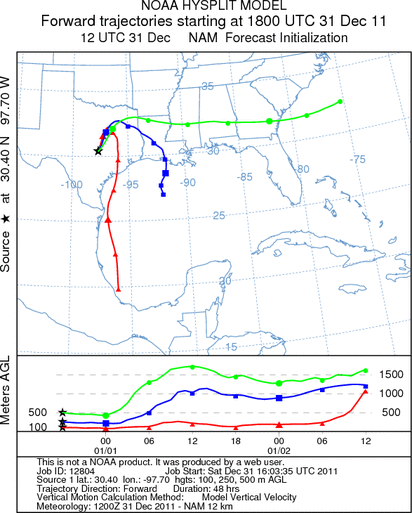
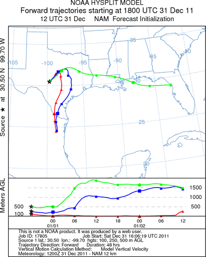
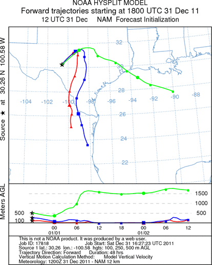
Trajectory Start (s) (shown by *
on map): Austin, TX; Junction, TX; Sonora, TX.
AUSTIN
JUNCTION
SONORA
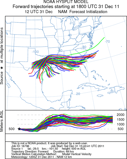
EDWARDS PLATEAU COMPOSITE
Prepared by: Estelle
Levetin (Faculty of Biological
Science, The
University of Tulsa, 800 S. Tucker Dr., Tulsa, OK 74104) and ) and Peter
K Van de Water (Department of Earth and Environmental Science, California State University Fresno,
2576 East San Ramon Avenue, M/S ST24, Fresno CA 93740-8039). This forecast gives the anticipated future track of
released Mountain Cedar pollen, weather conditions over the region and along the forecast pathway, and an estimated
time of arrival for various metropolitan areas.
Questions: Aerobiology Lab e-mail: pollen@utulsa.edu
Return to Forecasting Home Page