
The University of Tulsa
Mountain Cedar Pollen Forecast
Metropolitan Area |
Exposure Risk |
|
Dallas/Fort Worth |
High |
|
Austin |
High |
|
San Antonio |
High |
Date Issued: 17 December 2012
Mountain Cedar Location(s): Edwards Plateau, Texas
Regional Weather: Monday, December 17 TX/OK:
Across the region the weather will continue to be unseasonably warm today with most areas in the upper 60s to
low 70s, extending across Texas into southern and central Oklahoma. A ridge of high pressure will dominate across
the region for the next couple of days. This morning clear skies have predominated across the region with mostly
sunny skies to the north and sunny skies across Texas. Winds today will be from the west and northwest and moderate
to light levels, gaining strength towards the south. Tonight clear skies will predominate with some clouds building
around the eastern edge of the Edwards Plateau northward into the Dallas/Ft. Worth region. Low temperatures will
be in the 40s where the partly cloudy skies occur and into the 30s across the rest of the region. Tomorrow,
sunny and mostly sunny skies will return. Temperatures warm with almost the entire region reaching into the 70s.
Across central and southern Texas temperatures will reach into the upper 70s. Winds will be from the south and
southwest at light to moderate levels. Tomorrow night low temperatures will be very mild with the communities
surrounding the Edwards Plateau in the mid to upper 50s. San Antonio is expected to remain near 60. The skies
will be mostly clear to the north with lows in the low 50s and 40s. Across the Edwards Plateau skies will eventually
become partly cloudy. Winds across the region will be from the south at moderate levels.
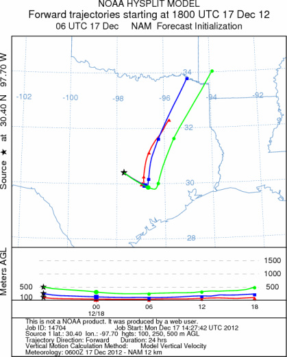
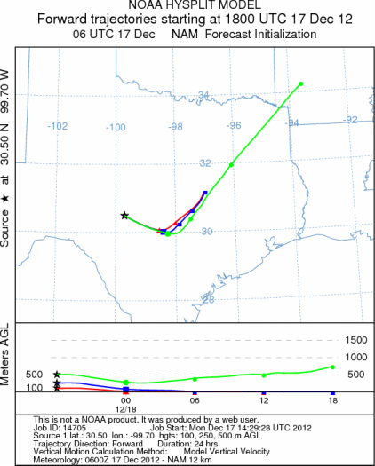
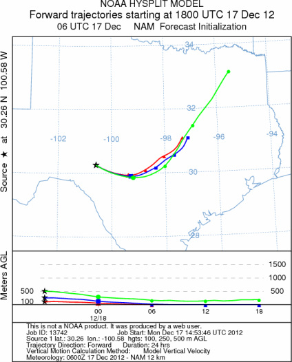
Trajectory weather: Air mass trajectories over the Edwards Plateau move towards the east today on westerly
winds then this afternoon and evening the winds will come from the southwest and the trajectories take a more northeasterly
direction. Across Texas today sunny skies and warm conditions will dominate over the entire region. Temperatures
are expected to reach into the upper 60s to low and mid 70s. Winds will start from the west but shift to a dominant
southwesterly direction and increase in strength in the southern areas going into the afternoon and evening. Overnight
the winds will calm, especially north, but maintain a southwesterly flow. Tomorrow skies will be clear again across
the region with warm temperatures, highs in the upper 70s, and moderate winds maintaining themselves out of the
southwest. Tomorrow night skies will be mostly clear, although partly cloudy skies will build along the eastern
edge of the Edwards Plateau. Temperatures will be very mild with most reading across Texas in the 50s. Slightly
cooler conditions will occur towards west Texas and into southern Oklahoma.
OUTLOOK: *** High Threat today and High threat Tomorrow *** Good conditions for
pollen release today and good conditions tomorrow with moderate conditions for entrainment and transport both days.
Warm conditions with moderate wind speeds will occur across the Edwards Plateau today and tomorrow. Tomorrow temperatures
will maintain the good conditions with sunny skies therefore there is a high threat both days. The dominant west
and southwesterly flow will move any entrained pollen towards the east and then northeast later today and into
tomorrow. Therefore the communities at risk are east of the primary populations in east Texas, southeastern most
Oklahoma as well as Arkansas. The pollen release season is just beginning therefore there may be limited amounts
of pollen ready to be shed, however the warm temperatures may accelerate the ripening process and set the stage
for heavy release soon.
Trajectory Start (s) (shown by *
on map): Austin, TX; Junction, TX; Sonora, TX.
AUSTIN
JUNCTION
SONORA
EDWARDS PLATEAU COMPOSITE
Prepared by: Estelle
Levetin (Faculty of Biological
Science, The
University of Tulsa, 800 S. Tucker Dr., Tulsa, OK 74104) and ) and Peter
K Van de Water (Department of Earth and Environmental Science, California State University Fresno,
2576 East San Ramon Avenue, M/S ST24, Fresno CA 93740-8039). This forecast gives the anticipated future track of
released Mountain Cedar pollen, weather conditions over the region and along the forecast pathway, and an estimated
time of arrival for various metropolitan areas.
Questions: Aerobiology Lab e-mail: pollen@utulsa.edu
Return to Forecasting Home Page