
The University of Tulsa
Mountain Cedar Pollen Forecast
Metropolitan Area |
Exposure Risk |
|
Dallas/Fort Worth |
Moderate |
|
Austin |
Moderate |
|
San Antonio |
Moderate |
Date Issued: 19 December 2012
Mountain Cedar Location(s): Edwards Plateau, Texas
Regional Weather: Wednesday, December 19 TX/OK:
Across the region the weather will continue to be unseasonably warm today but changes are underway that will bring
cooler temperatures tonight and tomorrow. Most areas will be in the middle to upper 70s with high temperatures
expected to reach the 80s in San Antonio and other areas along the southern edge of the Edwards Plateau. As the
weather begins to change more humidity will be moving in from the southwest on moderate to strong winds. The greater
humidity will result in mostly cloudy conditions extending across Texas into southern and central Oklahoma. From
Dallas southward along the edge of the Edwards Plateau wind gust may reach 25 to 30 miles per hour. Tonight skies
will be partly cloudy as temperatures drop into the 30s and winds switch from the southwest to the northwest.
Along with the wind change, strong winds will occur as the predominant southwesterly flow is replaced by much
colder air from the north. The wind shift will be reflected in the low temperatures that will be in the 30s and
40s. Tomorrow high temperatures will drop be at least 20 degrees. Todays 70s will mostly be in the low to
mid 50s. Skies across the region will be mostly sunny over the Edwards Plateau and sunny skies in the surrounding
areas. On the Plateau winds will begin to calm, but will maintain strong conditions with gusts at 30 to 35 miles
per hour.in the communities surrounding the eastern Edwards Plateau. Tomorrow night skies will be clear to the
north and mostly clear over the Plateau region. The surrounding communities will be partly cloudy. Nightime temperatures
will drop below freezing with most readings will be in the 20s across the region. Winds to the north will remain
from the northwest, but to the west southwestern winds will begin to push back into the area.
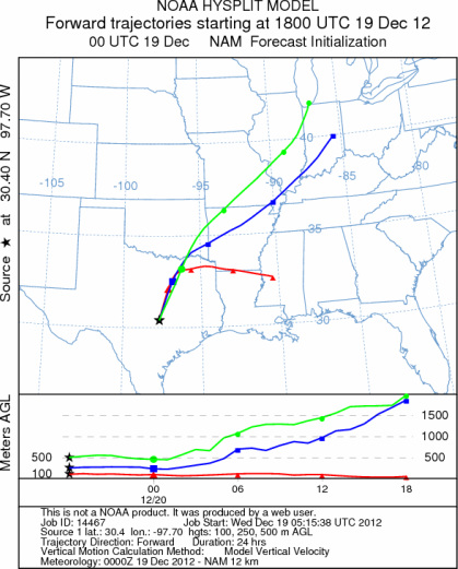
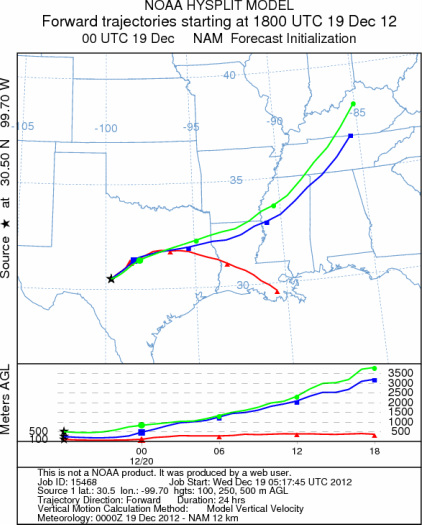
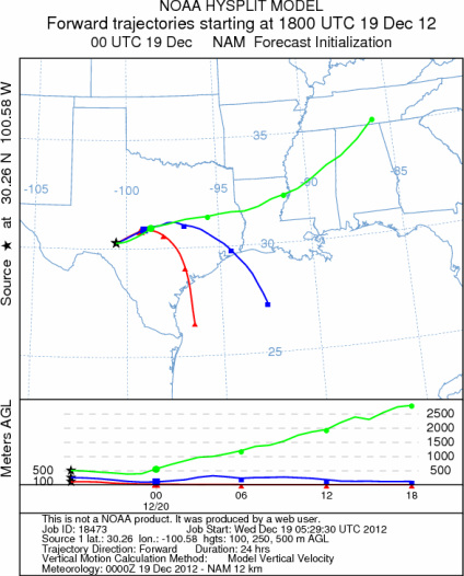
Trajectory weather: Air mass trajectories over the Edwards Plateau move northeast today on strong southwesterly.
On the ground, gusts reaching into the 30 mph level are possible. Across Texas today mostly cloudy skies and
warm conditions will dominate over the entire region. Change will begin during the afternoon and into the evening
with the winds switching from the southwest to the northwest. Temperatures are expected to drop into the mid to
lower 40s and into the 30s. Overnight the winds will maintain their strength. Tomorrow cooler conditions will
occur with most of the trajectories moving towards the south and southeast. Again wind strength will be gusty
especially around the edge of the Edwards Plateau. With the change in the winds will come cooler temperatures
during the day and then below freezing temperatures tomorrow night.
OUTLOOK: *** Moderate Threat today and Low threat Tomorrow
*** Good conditions for pollen release today but poor conditions tomorrow as the winds shift. Good conditions
for entrainment and transport both days with strong gusty winds and lots of turbulence. Warm conditions with strong
wind speeds will occur across the Edwards Plateau and to the east today. Overnight winds will change from a dominant
southwesterly direction to one from the northwest. With this change cold conditions will infiltrate the region.
The season of pollen release from Juniperus ashei is just beginning therefore there may be limited amounts of
pollen ready to be shed, especially with a number of days of good conditions for release. A recent canvas of the
trees in central Texas showed only about 5% of the cones ready to shed pollen. Tomorrow cold conditions should
dampen pollen release. For these reasons there is a moderate threat today and a low threat tomorrow. See the
diagram of tomorrow's matrix calculation for the dramatic change in winds that will occur.
Trajectory Start (s) (shown by *
on map): Austin, TX; Junction, TX; Sonora, TX.
AUSTIN
JUNCTION
SONORA
EDWARDS PLATEAU COMPOSITE
Prepared by: Estelle
Levetin (Faculty of Biological
Science, The
University of Tulsa, 800 S. Tucker Dr., Tulsa, OK 74104) and ) and Peter
K Van de Water (Department of Earth and Environmental Science, California State University Fresno,
2576 East San Ramon Avenue, M/S ST24, Fresno CA 93740-8039). This forecast gives the anticipated future track of
released Mountain Cedar pollen, weather conditions over the region and along the forecast pathway, and an estimated
time of arrival for various metropolitan areas.
Questions: Aerobiology Lab e-mail: pollen@utulsa.edu
Return to Forecasting Home Page