
The University of Tulsa
Mountain Cedar Pollen Forecast
Metropolitan Area |
Exposure Risk |
|
Dallas/Fort Worth |
Moderate |
|
Austin |
Moderate |
|
San Antonio |
Moderate |
Date Issued: 20 December 2012
Mountain Cedar Location(s): Edwards Plateau, Texas
Regional Weather: Thursday, December 20 TX/OK: Across
the region the weather change that occurred overnight will bring cooler weather with very strong winds but sunny
skies. Unlike the last few days, today will see high temperatures at least 20 degrees cooler. Most areas are
expected to only reach into the 50s. Winds will be from the north and northwest at moderate to strong levels.
Gusts will be in the 30-40 mph range along the southeastern edge of the Edwards Plateau. Winds will begin to
die down during the afternoon with light levels occurring overnight. Low Temperatures across the region tonight
will be will within the twenties and teens across the region. To the north and east predominantly northwesterly
winds will occur. To the southwest on the Edwards Plateau they will begin to turn back to a southwesterly flow.
Tomorrow skies will be sunny in most regions with daytime temperatures beginning to warm. Tomorrow the western
areas of the Edwards Plateau will be in the low 60s with light to moderate winds from the south. Across the eastern
side of the Edwards Plateau winds will start from the north but shift, coming from the southeast. Temperatures
will be in the upper 50s. Tomorrow night most skies will be clear but partly cloudy conditions will occur in
Austin to San Antonio. Overnight lows will climb into the upper 20s to low 30s. Winds will be from the south
to southwest at light levels.
Trajectory weather: Air mass trajectories over the Edwards Plateau move southward today on strong north
and northwesterly winds. On the ground, gusts reaching upwards of40 mph are possible. Across Texas today mostly
clear skies but with cool conditions will dominate. The clear skies will remain overnight but temperatures will
drop significantly iwht most areas in the low 20s to upper teens. Tomorrow, sunny skies will remain with some
warming. The warmest areas in the forecast region will get back into the low 60s. The warming will occur as
the northwesterly and northerly winds shift to a warmer southwesterly flow. The communities along the eastern
edge of the Edwards Plateau will continue to have a northwest flow early but will switch during the day coming
from a southeasterly direction. Overnight, mostly clear skies will return with partly cloudy conditions in the
Edwards Plateau edge communities. Overnight lows will be in the mid to low 30s. The change from the predominant
northwesterly winds to a more southwesterly flow will result in the air mass trajectories moving primarily southwated
then swirling back over Texas.
OUTLOOK: *** Low Threat today and Moderate threat Tomorrow *** Marginal conditions for pollen release today
but better conditions tomorrow as the winds shift and warmer conditions return. Good conditions for entrainment
and transport today with strong gusty winds and lots of turbulence, tomorrow winds will calm. Cold conditions with
strong wind speeds will occur across the Edwards Plateau and to the east today. Overnight winds will maintain
a northwesterly direction but will shift to the southwest beginning tonight. With this change cold conditions
will begin to be influenced by the warmer southwesterly breezes.. The season of pollen release from Juniperus
ashei is near its beginning therefore there may be limited amounts of pollen ready to be shed. However a number
of patients have contacted the modeling team to report strong allergy symptoms. In those areas with significant
numbers of trees patients susceptible to J. ashei pollen should expect increasing exposure and allergy outcomes.
Trajectory Start (s) (shown by *
on map): Austin, TX; Junction, TX; Sonora, TX.
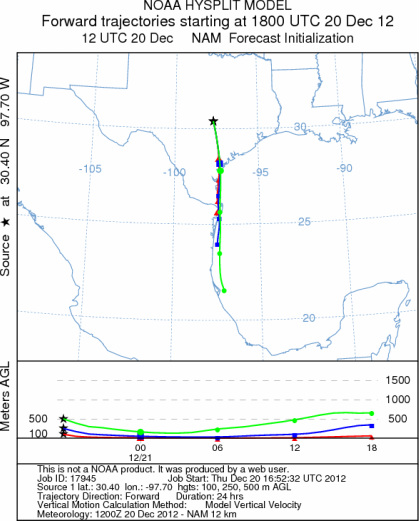
AUSTIN
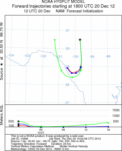
JUNCTION
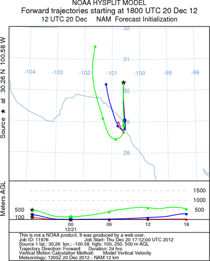
SONORA
EDWARDS PLATEAU COMPOSITE
Prepared by: Estelle
Levetin (Faculty of Biological
Science, The
University of Tulsa, 800 S. Tucker Dr., Tulsa, OK 74104) and ) and Peter
K Van de Water (Department of Earth and Environmental Science, California State University Fresno,
2576 East San Ramon Avenue, M/S ST24, Fresno CA 93740-8039). This forecast gives the anticipated future track of
released Mountain Cedar pollen, weather conditions over the region and along the forecast pathway, and an estimated
time of arrival for various metropolitan areas.
Questions: Aerobiology Lab e-mail: pollen@utulsa.edu
Return to Forecasting Home Page