
The University of Tulsa
Mountain Cedar Pollen Forecast
Metropolitan Area |
Exposure Risk |
|
Dallas/Fort Worth |
Low |
|
Austin |
Moderate |
|
San Antonio |
Moderate |
Date Issued: 24 December 2012
Mountain Cedar Location(s): Edwards Plateau, Texas
Regional Weather: Monday and Tuesday, December 24 and
December 25 TX/OK: Across the region today will begin with a mix of conditions heading towards a significant
degradation of conditions late this afternoon, and into tomorrow. Today skies will begin as partly cloudy to the
north and across the Edwards Plateau. In the edge communities northward into the Dallas/Fort Worth region skies
will be more sunny to begin the day but will also gain cloudy conditions through the day. Temperatures today will
remain in the 60s across the Plateau, with the edge communities in the lower 70s and upper 60s. Winds will
be from the north and northeast building to moderate levels over during the day. Across the Edwards Plateau winds
will come from the east. The easterly wind direction will build in moisture with cloudy skies building over the
region by the evening. With the added moisture a significant chance of showers and thunderstorms are forecast
for this evening, with the Dallas to Austin and San Antonio corridor expecting to have a 50% chance of showers
and thunderstorms. Temperatures overnight will be mild dropping into the 40s and 50s. Over the Plateau temperatures
tonight will be 10 degrees cooler, dropping into the lower 40s and upper 30s. Winds across the area will be
from the east to southeast bringing in moisture. In Oklahoma cold conditions will occur with most areas beginning
to drop into the 20s and 30s. On Christmas Day Conditions will continue to deteriorate with cold strong winds
building from the north and northwest. Cloudy skies will predominate across Oklahoma and the Edwards Plateau will
see partly cloudy skies. In the edge communities sunny conditions will begin the day but there will be an increasing
chance of showers of rain and thunderstorms. Across Oklahoma the precipitation is likely to arrive as snow. Temperatures
across the north will remain in the 20s and 30s for Christmas day. Over the Edwards Plateau temperatures will
barely rise into the 50s and in the edge communities temperatures will reach into the low 60s. Winds will be
strong across the region with gusts into the 30 to 40 and even 45 mile per hour range. Overnight the region will
be very cold. Low temperatures on Christmas evening will be in the teens and twenties. Across Oklahoma and northern
Texas there will be snow and flurries.
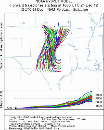
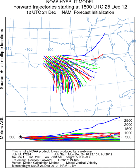
Trajectory weather: Air mass trajectories over the Edwards Plateau moves northward early on southerly winds
but by tomorrow the northerly flow will take over. Moderately warm conditions will occur ahead of the weather
changes beginning this evening and overnight. The winds will begin to turn to a more southerly flow beginning
in the north. As this occurs there will be an increasing chance of rain showers and thunderstorms. Tomorrow the
chance of rain will remain to the north and across the edge communities. The plateau will clear to partly cloudy
conditions but temperatures will struggle to get out of the 40s. Winds will remain very strong from the northwest,
with gusts in the 40+ miles per hour. Tomorrow night cold temperatures take over with most areas in the 20s to
high teens. Skies will be clear except for the north where moisture and snow will move across the area.
OUTLOOK: *** Moderate Threat today and Poor threat Tomorrow ***
Moderate conditions for pollen release today and poor conditions tomorrow. Cold conditions and moisture
is moving into the region causing cloudy conditions and a chance of showers and thunderstorms this afternoon into
tomorrow. Tomorrow night will be very cold as a northerly flow takes over the region. Good conditions for entrainment
and transport will occur today as the fronts move through the region this afternoon, but the chance of rain will
tend to wash out any entrained pollen. Temperatures in the 60s today and just barely reaching the 60s tomorrow
with very strong wind speeds across the region. northeasterly winds will back moisture into the Texas region resulting
in a significant chance of rain tonight and tomorrow. Tomorrow very cold conditions will arrive with tomorrow
nights temperatures in the teens and twenties.
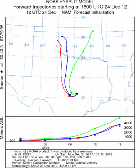
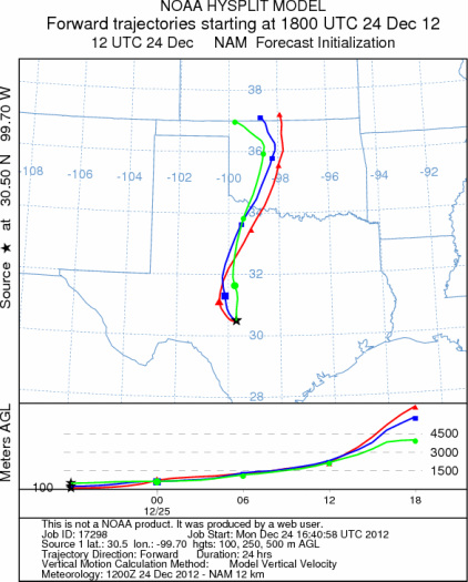
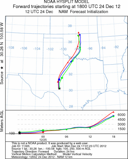
Trajectory Start (s) (shown by *
on map): Austin, TX; Junction, TX; Sonora, TX.
AUSTIN
JUNCTION
SONORA
EDWARDS PLATEAU COMPOSITE
Monday
Tuesday
Prepared by: Estelle
Levetin (Faculty of Biological
Science, The
University of Tulsa, 800 S. Tucker Dr., Tulsa, OK 74104) and ) and Peter
K Van de Water (Department of Earth and Environmental Science, California State University Fresno,
2576 East San Ramon Avenue, M/S ST24, Fresno CA 93740-8039). This forecast gives the anticipated future track of
released Mountain Cedar pollen, weather conditions over the region and along the forecast pathway, and an estimated
time of arrival for various metropolitan areas.
Questions: Aerobiology Lab e-mail: pollen@utulsa.edu
Return to Forecasting Home Page