The University of Tulsa
Mountain Cedar Pollen Forecast

Metropolitan Area |
Exposure Risk |
|
Oklahoma City |
Low |
|
Tulsa |
Low |
|
St. Louis MO |
Low |
Date Issued: 27 December 2012
Mountain Cedar Location(s): Arbuckle Mountains, OK
Regional Weather: Thursday, December 27 TX/OK:
Across the region the weather begins to climb back from cold conditions. Today and tonight winds will be from
the south at moderate levels with sunny and partly sunny skies. In Oklahoma today partly cloudy skies will occur
with high temperatures in the low to mid 40s. Winds will be from the south to southeast at moderate levels.
Towards the evening mostly cloudy to partly cloudy skies will build and low temperatures will fall into the 20s.
Winds will become light and variable. Across Texas today, mostly sunny skies will occur to the east and partly
cloudy skies will occur over the Edwards Plateau. High temperatures will run from the upper 40s in the Dallas/Fort
Worth area into the 50s to low 60s across the central Edwards Plateau. Winds will remain at lite to moderate
from the south. Overnight the edge communities will build fog with the potential of drizzle. The region will
stay above the freezing point with temperatures in the 30s to the north and across the Edwards Plateau, and in
the 40s in the surrounding edge communities. Early morning winds will begin to switch back, coming from the northwest
for Friday. On Friday, the northern areas will have an increasing chance of showers from southern Oklahoma across
the Dallas/Fort Worth metro areas and along the eastern edge of the Edwards Plateau. There is a 20% chance of
showers along with fog and drizzle in these areas. Conditions will be warm and humid. High temperatures to the
north will remain in the 40s today but along the Edwards Plateau temperatures will warm into the 60s. The western
side of the Edwards Plateau will rise into the upper 50s. Winds will be lite to moderate from the northwest throughout
the day and overnight. Skies will be mostly clear allowing for a cool down Friday night. Low temperatures will
fall into the 30s in the surrounding communities and into the 20s across the Plateau. Winds will remain from
the northwest at lite to moderate levels.
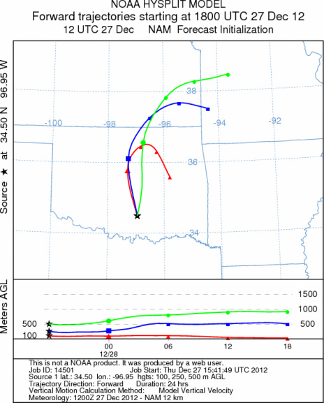
Trajectory weather: Air mass trajectories over the Arbuckle Mountains move northward and then are moved
to the northeast tonight as winds switch to a northwesterly flow. On the ground, light to moderate winds will
occur across the region. Cold conditions from the storm earlier in the week will remain. Todays high in the
Arbuckle Mountains is expected to be only in the mid 40s and that will fall into the low 40s tomorrow, along
with a 20% chance of showers tomorrow as well. Winds will be relatively stable across the region. Tonight low
temperatures will fall below freezing with readings in the upper 20s. Tomorrow partly cloudy skies will occur
with a 20% chance of showers and high temperatures only in the lower 40s. Tomorrow night most areas will fall
into the lower 20s with moderate winds.
OUTLOOK: *** Low Threat today and Low threat Tomorrow *** Poor conditions for
pollen release today and tomorrow as the area remains in the 40s. Moderate conditions for entrainment and transport
will occur today and tomorrow with cool air and only lite to moderate winds. In addition tomorrow there is a 20%
chance of showers with heightened humidity levels. Conditions will not improve tomorrow but will continue to be
cold during the day and at night. Temperatures in the 40s today and tomorrow with lite to moderate wind speeds
and high humidity should limit any pollen release. If you are traveling southward into Texas, we continue to have
patients contact the modeling team to report strong allergy symptoms. In those areas with significant numbers
of trees patients susceptible to J. ashei pollen should expect increasing exposure and allergy outcomes. Areas
outside of the tree population will have less chance of exposure.
Trajectory Start (s) (shown by black
star on map): Davis, OK.
Prepared by: Estelle
Levetin
(Faculty
of Biological Science, The University of Tulsa, 800 S. Tucker Dr., Tulsa, OK 74104) and Peter
K Van de Water
(Department of Earth and Environmental Science, California State University Fresno, 2576 East San Ramon Avenue,
M/S ST24, Fresno CA 93740-8039). This forecast gives the anticipated future track of released Mountain Cedar pollen,
weather conditions over the region and along the forecast pathway, and an estimated time of arrival for various
metropolitan areas.
Questions: Aerobiology Lab e-mail: pollen@utulsa.edu
Return to Forecasting Home Page