The University of Tulsa
Mountain Cedar Pollen Forecast

Metropolitan Area |
Exposure Risk |
|
Oklahoma City |
Low |
|
Tulsa |
Low |
|
St. Louis MO |
Low |
Date Issued: 28 December 2012
Mountain Cedar Location(s): Arbuckle Mountains, OK
Regional Weather: Friday, December 28 TX/OK:
Across the region the weather continues to climb back from cold conditions earlier in the week. However, today,
tonight and tomorrow winds will be from the north once again bringing cold air into the region. This morning across
Oklahoma and northern portions of Texas fog and drizzle are in the forecast. There is a 40% chance of snow in
Oklahoma City and 20% chance of snow in the Arbuckle Mountains. A good chance of drizzle will occur in Dallas
southward along the eastern edge of the Edwards Plateau, through Austin as well as San Antonio. High temperatures
today will remain in the 30s in Oklahoma but will warm to the 40s, 50s and mid 60s through Dallas, Austin and
San Antonio. On the Edwards Plateau, mostly sunny skies will occur with temperatures from the mid 40s to mid
50s. Across the entire region winds will be moderate from the north building towards the afternoon with many
areas having gusts as high as 30 mph. Tonight mostly clear skies will remain with very cold conditions. In Oklahoma
low temperatures in the teens will be widespread. To the south in Texas expect temperatures in the 20s overnight
region wide. Winds will remain at moderate levels from the north and northwest. Tomorrow, a slight warming will
occur with sunny skies across the area. Temperatures in Oklahoma will be in the low to mid 40s and winds will
be light and variable. In Texas high temperatures will reach into the mid-50s. Winds will be from the north
and northeast, except on the Edwards Plateau where a east to southeasterly wind will signal a shift that will continue
into the evening. Winds will be lite at 5 to 10 mph. Tomorrow night low temperatures will once again drop into
the mid 20s across the region. Winds will be light from the northeast in most areas except the Edwards Plateau
where winds will be from the southeast.
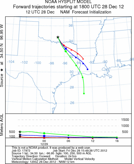
Trajectory weather: Air mass trajectories over the Arbuckle Mountains move southward today, tonight and
tomorrow on northerly to northeasterly winds. On the ground, moderate winds will occur across the region today
and there is a 20% chance of snow along with fog this morning. Cold conditions from the storm earlier in the week
and the northerly flow over the region will remain. Todays high in the Arbuckle Mountains is expected to be only
in the mid to upper 30s. Similar conditions are expected tomorrow but with temperatures getting into the mid
to low 40s. Tonight low temperatures will fall well below freezing with readings in the lower teens. Tomorrow
night most areas will return into the mid to lower 20s with lite and variable winds.
OUTLOOK: *** Low Threat today and Low threat Tomorrow *** Poor conditions for
pollen release today and tomorrow as the area remains in the 30s. Moderate conditions for entrainment and transport
will occur today and tomorrow with cool air and only lite to moderate winds. In addition the day will start with
a 20% chance of showers and heightened humidity levels. Conditions will not improve tomorrow but will continue
to be cold during the day and at night. Temperatures in the 30s today and 40s tomorrow with lite to moderate
wind speeds and high humidity should limit any pollen release.
Trajectory Start (s) (shown by black
star on map): Davis, OK.
Prepared by: Estelle
Levetin
(Faculty
of Biological Science, The University of Tulsa, 800 S. Tucker Dr., Tulsa, OK 74104) and Peter
K Van de Water
(Department of Earth and Environmental Science, California State University Fresno, 2576 East San Ramon Avenue,
M/S ST24, Fresno CA 93740-8039). This forecast gives the anticipated future track of released Mountain Cedar pollen,
weather conditions over the region and along the forecast pathway, and an estimated time of arrival for various
metropolitan areas.
Questions: Aerobiology Lab e-mail: pollen@utulsa.edu
Return to Forecasting Home Page